| This EarthCache developed by an |
 |
 |
The Lower Liesbeek
[Lies = water reeds; beek = stream]
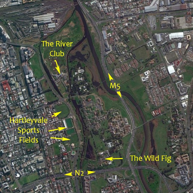
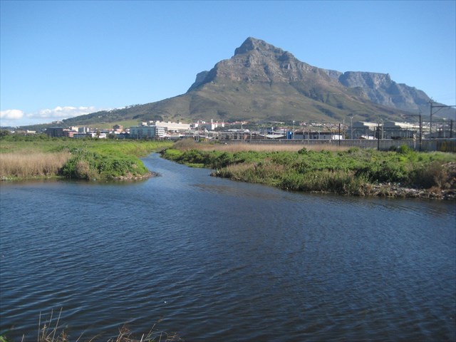
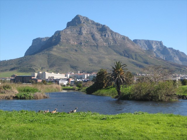
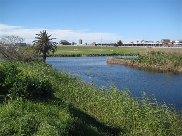
Orientation: Lower Liesbeek Earth Cache
Human Interventions
have changed the course and character of the Lower Liesbeek
Introduction
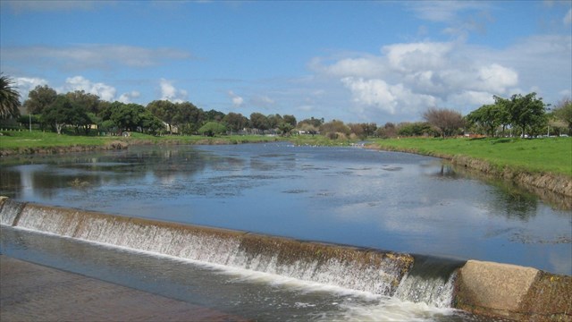
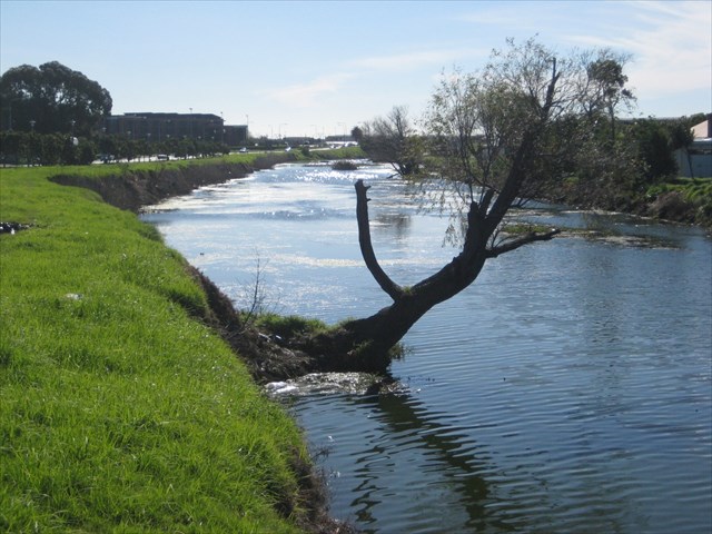
The recorded history of the lower Liesbeek shows that flooding of the floodplain and estuarine marshland has occurred frequently and has always been regarded as a problem. From the early agricultural efforts, through early settlement, and 20th century urbanization and road construction, unsuccessful efforts have been made to reduce the impact of floods by deepening, widening and channelling the river. This has effectively moved the heavy winter rain water more rapidly to the sea level marshes where it spreads out in sheets of flood water. In recent years it has been recognised that urbanization of the catchment is causing storm water to run into the river system rapidly as the impervious urban surfaces prevent rain from filtering into the ground. Concrete canalization of the river also prevents water from percolating into the river bed and accelerates the speed at which flood volumes reach the sea level marshlands. This recognition has led to late 20th century changes to the river and attempts are now being made to slow down the rush of storm water. Small weirs have been constructed in the channel, holes have been cut through the floor of the concrete channel to allow water to soak into the ground; artificial wetlands have been created adjacent to the river into which flood waters are diverted to further slow the rush of water towards the sea. West of the Mowbray Protea Hotel and the Wild Fig Restaurant a berm that was built to prevent flood waters covering former wetlands has now been breached and a channel dug to facilitate water flooding the wetlands whenever the river rises. We are learning to design with nature rather than attempting to impose designs on nature.
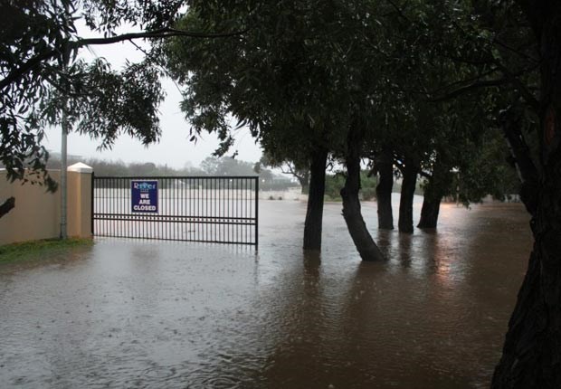
Lower Liesbeek in Flood 2012
Logging Requirements
TO AUTHENTICATE A LOG FOR THIS EARTH CACHE YOU NEED TO ANSWER SEVEN QUESTIONS (INDIVIDUALLY AND IN YOUR OWN WORDS IF PART OF A CACHING GROUP) AND EMAIL YOUR ANSWERS VIA MY GEOCACHING PROFILE.
At GZ [S33 56.188 E 18 28.522]
A. Explain why it would have been impossible to stand at this location 200 years ago.
B. What name did an early visitor to the Royal Observatory give to the ford across the Liesbeek?
At observation point 1 [S 33 56.174 E 18 28.574]
Here you need to
C. Look SOUTH. What changes to this landscape have occurred in the past 100 years?
D. Look NORTH. What changes to this landscape have occurred in the past 100 years?
At observation point 2 [S 33 56.557 E 18 28.689]
E. For what purpose did the Khoekhoen use the banks of the Liesbeek before Dutch settlement?
General Questions
F. What geomorphological and geological features caused the Observatory to be built where it is?
G. Do you think the proposed re-development of the River Club site will prevent flooding of the Lower Liesbeek in the future? Briefly give the reasons for your answer.
Early Changes to the Landscape
Historically, the Liesbeek and Black rivers joined to form the Salt river which, together with the Diep River, flowed into an estuarine wetland complex of tidal lagoon, mudflats, sand dunes, and islands. Hippos and other large animals—elephant and Cape buffalo—ensured that there were open channels and pools amongst the reed beds of the wetlands.
A 17th century description of the areas geomorphology states: “The convergence of a number of rivers occurs [about 2.5 km from the Castle]. The Verscherivier is joined [by the Diep River] about 2 km from the sea and about 0.5 km further on the Brackerivier, which is formed from the junction of the Liesbeek and Swart rivers. The total length of this large banana shaped lagoon, called the Salt River, is about 3 km. The width, dependent on the season, varies from 0.5 to 1 km. The lagoon has an opening to the sea. Harders [mullet] and other fish are found in the estuary, which is subject to tides – hence the name Salt River.” [Translation from D Sleigh Die Buitenposten.]
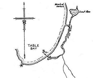
17thCentury Map of Salt River Estuary
In 1652, Jan van Riebeeck, in his journal, described the Liesbeek valley, with considerable over-statement, as "the finest and richest arable and pasture-land in the world, wide and level" through which "countless fresh rivulets wind", the largest of which was "half as wide as the Amstel" and "quite deep".
The first significant impacts on the geomorphology of the Liesbeek occurred in the late 17th century when the first European agriculturalists moved onto the river’s floodplain, dug drainage channels, and planted crops: fruit, vegetables and wheat were grown. The first farms adjacent to the Liesbeek were granted to fourteen free burgers in 1657 and there were immediate reports of flooding: "Newly sown lands submerged, seemingly a regular inundation; wagon road to forest impassable". [Van Riebeek's journal 28 June 1657]. In 1659, riparian landowners were instructed to clear the banks of undergrowth and to deepen the channel to prevent cattle from crossing and reduce the risk of flooding.
But despite these actions the Liesbeek floodplain continued to be inundated during winter floods, in 1686 Governor Van der Stel ordered the river banks strengthened and channels dug to drain the land: but the flooding continued. In 1744, and again in 1882, landowners were required to remove trees and bushes which were thought to be impeding flow and aggravating flooding.
Several farms were established on the ridge of Malmesbury Formation mudstones that separates the Liesbeek and Black rivers: from north to south these were Valkenberg, Bloemendal and Vredenberg. Valkenburg, built in 1770 by Cornelis de Waal, it is one of the oldest surviving farm houses along the Liesbeek. There was little development on the aeolian sands to the east of the Black River which remained marshland close to the river and shifting sands in what is today the suburb of Pinelands.
19th Century Developments
During the 19th century, the western side of the Liesbeek valley changed from agricultural to settled suburban, with some industrial development. But the land along the ridge between the Liesbeek and Black rivers was largely unaffected by these processes and dairy farming, to supply Cape Town with milk, predominated although some grain, fruit and vegetable production took place for most of the nineteenth century.
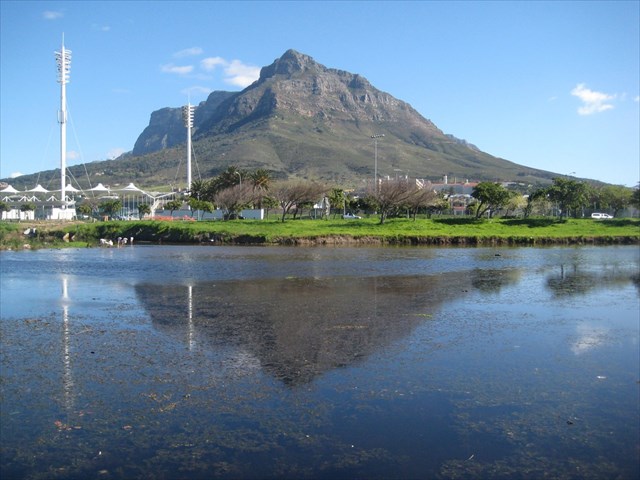
In 1820 the ‘King’s Most Excellent Majesty in Council’ authorized the ‘… Lords Commissioners of the Admiralty to cause an observatory to be erected at the Cape of Good Hope – the first modern astronomical observatory in Africa. Reverend Fallows, mathematician, astronomer and clergyman was appointed as Astronomer. Selecting a permanent site for an observatory became problematic. Most possible sites close to the city were unsuitable because of wind-blown dust or because Table Mountain’s tablecloth often obscured the night sky. The site finally selected was away from Table Mountain and was not affected by dust because it was in the middle of the marshlands at the confluence of the Liesbeek and the Black Rivers on a barren rocky mound—which Fallows recognized as a good source of building stone—known as Snake Hill. (Fallows saw ninety snakes killed in a single day during construction of the observatory.) Portion of the farm Valkenberg was sold to the Cape Colonial Government in 1827 to establish the Royal Observatory. According to one early resident, an astronomer once found a leopard on the observatory roof, and hippo could be seen in the surrounding marshes. That the resident was unimpressed with the observatory’s location can be inferred from the comments: “The ‘Slough of Despond’ intercepts our main road, and near ‘Dismal Swamp’ stands our stately abode. To cross the Slough of Despond Fallows appealed to the Governor of the Cape to replace the ford across the Liesbeek with a simple bridge to enable reliable access between the Observatory and the city centre.
In 1881 Sir William Porter bequeathed funds to establish a reformatory, Valkenberg Manor House and out-buildings were acquired for this purpose, but in 1899 they too were acquired by the Government of the Cape Colony to establish the Valkenberg Psychiatric Hospital. Ninety years later, in 1985, the Manor House became the property of the National Monuments Council. Shortly thereafter it was leased to and restored by Rosenfontein Restaurants.
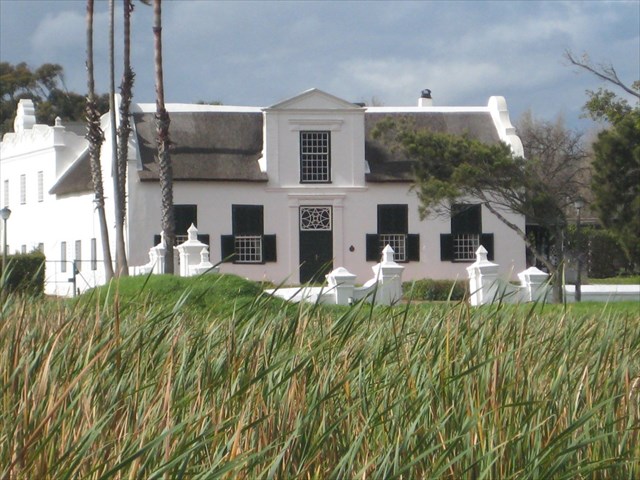
Valkenberg Manor House as it possibly appeared across 17th Century Marshland
20th Century Changes to the Liesbeek
 |
 |
 |
| 1937 Landscape |
1958 Landcape |
1968 Landscape |
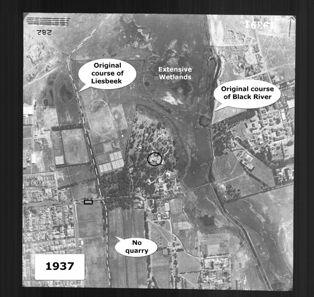
After severe floods in 1917, many property owners claimed damages from the local municipalities stating that the roads and bridges built alongside or over the Liesbeek had caused the flooding of their properties. This led to 11300 pounds being allocated to start the canalisation of the Liesbeek in Rondebosch. Further concreting of sections of the river took place at intervals, with major works and diversions occurring in the 1950s mainly to accommodate road expansion, but also in a further attempt to alleviate flooding. Some idea of the local geomorphology and landscape can be obtained from the earliest aerial photograph of the area between the Liesbeek and Black rivers that dates from 1937.
Lower Liesbeek Landscape 1937
During the early 1950s the actual course of the Liesbeek was changed significantly by human intervention, large areas of the wetland were filled in to accommodate the major freeway developments of Settlers Way, Black River and Liesbeek Parkways.
First the Liesbeek was diverted eastward from its original course into quarry excavations that had been dug to obtain materials to raise the Hartleyvale playing fields above flood level.
Restrained by a concrete weir the quarry site was flooded to form what has become known as Liesbeek Lake. This diversion was undertaken to provide enough space for construction of the Liesbeek Parkway between the river and the Hartleyvale sports fields.
This diversion occurred west of the original Valkenberg Manor House (now the Marriott Protea Hotel, Mowbray) and gave rise to the open water features and wetlands west of Liesbeek Lane that runs from the Observatory buildings to the Protea Hotel and Wild Fig restaurant.
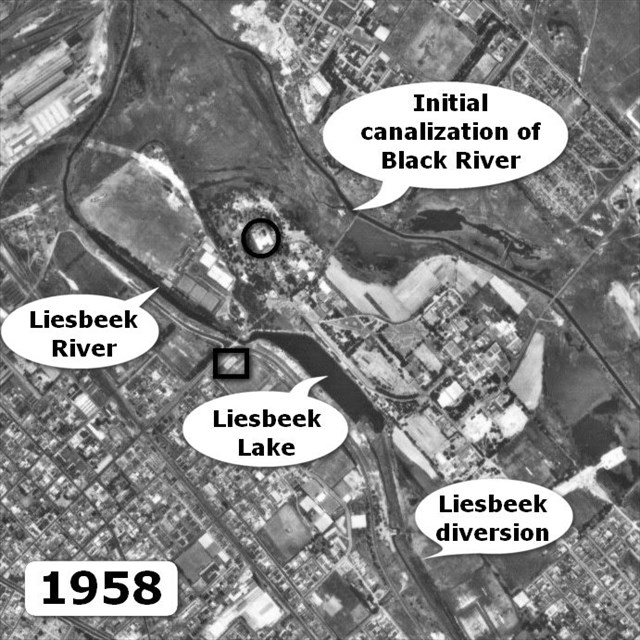
At this stage the river still flowed in its original course north of Observatory Road as is clearly seen in the 1958 aerial photograph.
Lower Liesbeek Landscape 1958
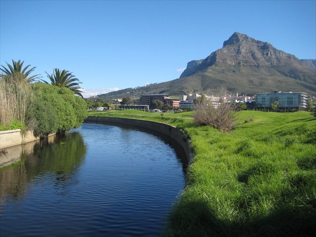
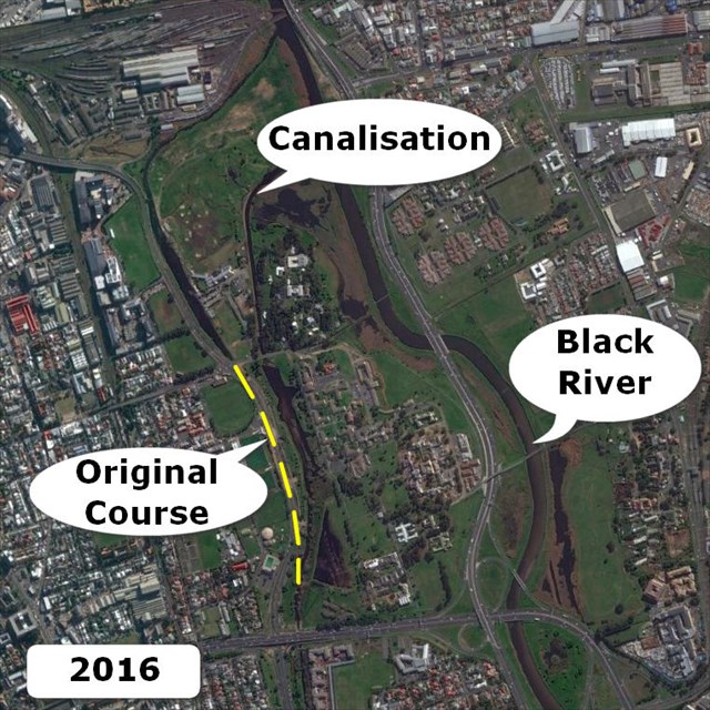
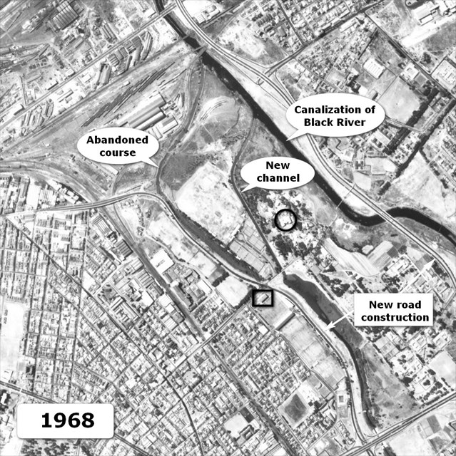
In the early 1960s a further major diversion to the course of the Liesbeek took place with a completely new concrete canal being constructed between Liesbeek lake and the Black River.
This left the original Liesbeek course as a blind channel that can be clearly seen from the intersection of the Liesbeek parkway and Observatory Road.
The way in which the courses of the Liesbeek and Black Rivers have been significantly altered can easily be seen by comparing the 1958 and 1968 aerial photographs of the location.
Lower Liesbeek Landscape 1968
Views of the Confluence of the Liesbeek and Black Rivers
 |
 |
 |
| Original Confluence |
Post 1960 Confluence |
Confluence looking east |
The Future
The River Club in Observatory is set to undergo a R4 billion re-development over four years, this will include residential, retail and commercial components including a hotel, gym, shopping centre, offices, conference centre and even schools.
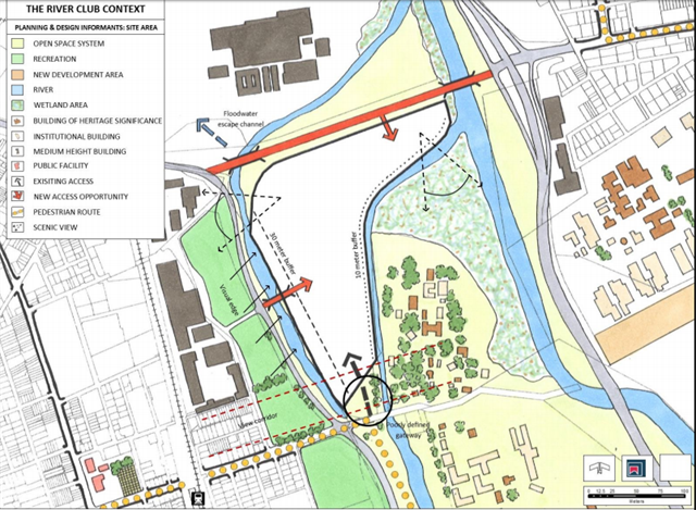
Proposed Re-development of River Club Site
These components will take up about five hectares of the site, while the remaining 10 hectares will be landscaped and rehabilitated for recreational use including a park, walking and cycling paths and an amphitheatre.
Substantial quantities of toxic landfill have been dumped in the far northern part of the River Club. If this fill is removed or used for selective landscaping, the land may become useful for flood accommodation in the confluence area (largely from the Black River). This will be done through a series of ponds, which would also serve to purify runoff.
The river edges will be made accessible to the public by means of appropriately located public pathways. The old Liesbeek course will be rehabilitated and the feasibility of diverting some of the flow from the Liesbeek into the old river course will be investigated. Redesigning and landscaping the banks of the canalised section of the Liesbeek to a more natural state will enhance the amenity value and ecological functioning of the river.
Since canalisation the Salt River and its tributaries have become more susceptible to flooding and frequent floods are known to take place at the River Club and surrounding areas. This can be ascribed to the following:
- The Salt River Canal was designed to be narrower than the original river channel, with an insufficient gradient between upstream areas and the mouth;
- The railway line bridges immediately downstream of the Liesbeek and Black River confluence are too low to accommodate floodwaters;
- The infilling of the Salt River lagoon and the removal of the attenuation capacity of the estuarine system;
- Increased run-off as a result of urbanisation in the catchment.
Most importantly in the context of flooding at the site, the width of the canal and height of railway bridges limit the cross sectional surface area through which floodwaters can flow in the reach of the Salt River canal immediately downstream of the River Club. Floodwaters therefore back-up into the River Club and surrounding areas. Consequently development should be kept outside the 50-year flood plain and no infilling of the flood plain should be considered.
Sources
J.N. Theron et al: The Geology of the Cape Town Area, Explanation of sheet 3318. Geological Survey, Department of Mineral and Energy Affairs, Republic of South Africa.
B. Warner: Royal Observatory, Cape of Good Hope, 1820-1831
Liesbeek Leisure Properties Trust: Redevelopment of the River Club, Observatory.
TRUP :Two Rivers Urban Park, www.trup.org.za
Spatial Information Services, Mowbray Cape Town. [Historical Aerial Photographs]
Google Earth: [2016 Imagery of Location]