La source
La source principale de la Seine est située en Côte-d'Or, près de la limite entre la Bourgogne et la Franche-Comté. Le plateau donne également naissance à plusieurs autres cours d'eau importants du nord de la France : la Marne, l'Aube et la Meuse.
Administrativement, la Seine prend sa source dur la commune de Source-Seine, à l'est du village, près de sa limite avec Poncey-sur-l'Ignon, à une quarantaine de km au nord-ouest de Dijon. Le site est facilement accessible, directement situé à côté de la route départementale 103, elle-même connexe à la D961. La source est protégée par un nymphée érigée en 1865 par les architectes Gabriel Davioud, Victor Baltard et Combaz, à la suite de l'achat du terrain par la ville de Paris. Il abrite une statue d'une nymphe fluviale, copie d'une œuvre du sculpteur bourguignon François Jouffroy.
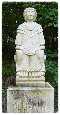
Dans l'antiquité, le site des sources de la Seine est situé sur le territoire des Lingons, une tribu celte occupant la région du plateau de Langres. A partir de la fin de la Tène (second âge du fer), il abrite un sanctuaire aménagé par les Lingons qui y construisent deux temples, une enceinte avec des colonnes et d'autres sculptures centrées sur la piscine et la source. A l'époque gallo-romaine, entre le Ier et la fin du IVe siècle, le sanctuaire est dédié à la Déesse Sequana, nymphe du fleuve.
Le sanctuaire est un lieu de pèlerinage et les fouilles ultérieures ont mis au jour plusieurs centaines d'ex-voto.
Le cours de la Seine
La Seine est partagée en cinq parties, d'amont en avale :
- la Petite Seine, de la source à Montereau-Fault-Yonne (confluence avec l'Yonne) ;
- la Haute Seine, de Montereau-Fault-Yonne à Paris ;
- la traversée de Paris ;
- la Basse Seine, de Paris à Rouen ;
- la Seine maritime, de Rouen à la Manche.
Le bassin versant de la Seine
Le bassin versant de la Seine d'une superficie de 79 000 km² est pratiquement entièrement compris dans le Bassin Parisien qui d'un point de vue géologique constitue un bassin sédimentaire affectant la forme d'une cuvette ouverte vers la Manche et l'Atlantique. Ce bassin est constitué par un empilement de formations géologiques à faible pente convergeant vers le centre et entre lesquelles s'intercalent d'importantes formations aquifères. Le relief du bassin versant de la Seine ne s'élève généralement pas au dessus de 300 m sauf sur sa marge sud-est dans le Morvan où il culmine à 900 m. La modicité de l'altitude moyenne du bassin versant explique les faibles pentes des cours d'eau (entre 0,01 et 0,03 m pour 100 m) qui coulent en se frayant leur chemin à travers les cuestas faisant saillie à l'est du bassin puis en incisant les plateaux du centre de la région.
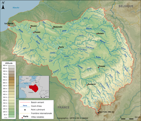
Carte topographique du bassin de la Seine
Hydrographie
Le Bassin Parisien connait un climat océanique avec un apport constant d'humidité véhiculé par les vents dominants d'Ouest. La pluviométrie est comprise entre 800 mm et 1 100 mm dans les régions côtières, s'abaisse jusqu'à 550 mm dans les régions centrales faute de relief (altitude inférieure à 200 m en île-de-France) avec un minimum dans la Beauce pour remonter sur les marges orientales avec un maximum de 1 300 m dans le Morvan. La Seine et trois de ses principaux affluents - l'Aube, la Marne et l'Oise - qui circulent dans des régions aux caractéristiques similaires (régime océanique, faible relief et géologie identique) partagent le même régime hydrographique avec un débit maximal en janvier et un minimum en août. Le Bassin Parisien comprend 9 aquifères qui s'intercalent entre les différentes couches géologiques. Le réseau hydrographique est relié en différents points directement à l'aquifère la moins profonde : en fonction de la hauteur des eaux elle alimente la Seine l'alimente ou est alimentée par celle-ci. Enfin la couche d'alluvions, présente dans les vallées avec une épaisseur inférieure à 10 mètres, constitue une dixième formation aquifère très productive.
La earthcache

Pour pouvoir valider cette earthcache, vous devrez répondre aux questions suivantes à partir des informations de cette page et celles relevées sur le terrain.
Merci d’envoyer vos réponses via mon profil ou via la messagerie geocaching.com, ne les donnez pas dans votre log.
Vous pouvez ensuite loguer la cache "found it", je vous contacterai en cas de problème.
1) En combien de parties est partagé le cours de la Seine ?
2) Quelle est la superficie de son bassin versant ? Quelle pente ont les cours d'eau qui s'y créent ?
3) WP1 : D'après le poteau de randonnée, à quelle altitude se situe la source de la scène ?
4) A quelle distance de la source se trouve le pont Paul Lamarche, le premier pont qui enjambe la Seine ? (trouvez et placez-vous sur ce pont et regardez sur votre GPS la distance à la earthcache).
5) WP2 : Sur le nymphée se trouve une plaque liée à l'érection de ce monument. En quelle année a-t-elle été gravée (date en bas) ?
6) Vous pouvez également ajouter à votre log une photo de vous ou de votre GPS à côté de la statue de Sequana (facultatif, mais grandement apprécié).
The source
The main source of the Seine is located in Côte-d'Or, near the border between Bougogne and Franche-Comté. The tray also gives rise to several other major rivers in northern France: the Marne, Aube and the Meuse.
Administratively, the Seine has its source hard the town of Source-Seine, east of the village, near its boundary with Poncey-sur-l'Ignon, about forty km northwest of Dijon. The site is easily accessible, directly next to the main road 103, itself connected to the D961. The source is protected by a nymphaeum built in 1865 by Gabriel Davioud architects Victor Baltard and Combaz, following the purchase of the land by the city of Paris. It houses a statue of a river nymph, a copy of a work of bourguignon sculptor François Jouffroy.
In ancient times, the site of the sources of the Seine located on the territory of Lingons, a Celtic tribe occupying the Langres Plateau region. From the end of the Tene (second Iron Age), it houses a shrine built by Lingones who built two temples, an enclosure with columns and other sculptures centered on the pool and the source. In Gallo-Roman times, between the first and the late fourth century, the shrine is dedicated to the Goddess Sequana, nymph of the river.
The sanctuary is a place of pilgrimage and subsequent excavations have unearthed hundreds of votive offerings.
The course of the Seine
The Seine is divided into five parts, from upstream to downstream:
- Little Seine, from the source to Montereau-Fault-Yonne (confluence with the Yonne);
- High Seine, from Montereau-Fault-Yonne to Paris ;
- the Paris crossing ;
- Low Seine, from Paris to Rouen ;
- Maritime Seine, from Rouen to the Channel.
The watershed of the Seine
The watershed of the Seine with an area of 79,000 km² is almost entirely within the Paris Basin which from a geological point of view is a sedimentary basin affecting the shape of an open bowl towards the Channel and the Atlantic. This basin is formed by a stack of geological formations low slope converging towards the center and between which are interspersed large aquifers. The relief of the Seine watershed does not usually rise above 300 m except on margin southeast in the Morvan where it peaks at 900 m. The low altitude of the average watershed explains the low slopes of the river (from 0.01 to 0.03 m to 100 m) flowing wending their way through the Cuestas projecting east the basin and by cutting the region's central highlands.
Topographic map of the Seine watershed
Hydrography
The Paris Basin knows an oceanic climate with a constant supply of moisture carried by the prevailing winds west. The rainfall is between 800 mm and 1100 mm in coastal areas, drops to 550 mm in the relief of misconduct central regions (altitude less than 200 m in Ile-de-France) with a minimum in the Beauce to go up on the eastern margin with a maximum of 1 300 m in the Morvan. The Seine and three of its major tributaries - Aube, Marne and Oise - that circulate in areas with similar characteristics (oceanic regime, low relief and geology identical) share the river system with a maximum flow rate in January and a minimum in August. The Paris Basin includes nine aquifers that are inserted between the different geological layers. The river system is connected at various points directly to the shallow aquifer: depending on the depth of water it supplies the Seine feeds and is fed by it. Finally the alluvial layer, present in the valleys with a thickness less than 10 meters, is a tenth highly productive aquifer.
The earthcache
To be allowed to validate this earthcache, you will have to answer the following questions from the information on this page and on the field.
Thank you for sending your answers via my profile or the geocaching.com messaging, don't take it in your log.
You may then post your log "found it", I shall contact you in case of problem.
1) Into how many parts is split the course of the Seine?
2) What is the size of the watershed? What gradient have rivers that create it?
3) WP1 : According to the hike stake, how high is the source of the scene?
4) How far from the source is Paul Lamarche Bridge, the first bridge over the Seine? (find and position yourself on this bridge and look on your GPS the distance to the earthcache).
5) WP2 : On the nymphaeum there is a plaque related to the erection of this monument. In what year she was engraved (dates below)?
6) You may also add to your log a picture of you or your GPS next to the statue of Sequana (optional but greatly appreciated).