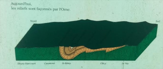
Le Bassin minier correspond à un petit synclinal qui s'étend sous la commune de Saint-Rémy-sur-Orne.
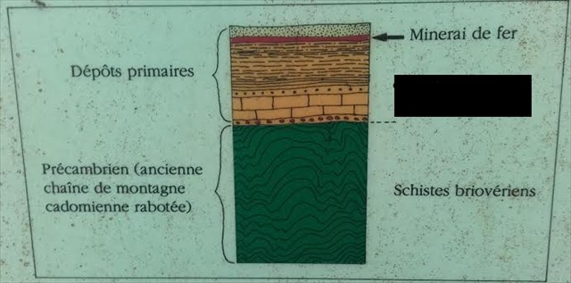
Il y a 420 millions d'années, toute la Normandie est sous la mer. Au fond d'elle se dépose des vases qui, au cours des millénaires, se transforment progressivement en schistes, en calcaire et en grès. Certains de ces derniers sont chargé en fines particules de fer.

A la période suivante, les mouvements des continents font apparaître dans la région une énorme montagne: la chaîne hercynienne. Les terrains en place sont plissés, écrasés, faillés. Le site de Saint-Rémy se situe au creux d'un très gros pli, un synclinal.

L'énorme travail d'érosion qui se déroule sur les millions d'années qui suivent ne laisse en place que la base de ce pli, en forme de cuillère.
Le gisement de Saint-Rémy est en place, Beaumont et le Mont-de-Vêpres constituent les bords de cette cuillère.
Aux coordonnées de la earthcache, vous trouverez un panneau d'informations sur les mines de fer, je ne m'étends pas ici sur la partie exploitation afin de vous laisser un peu de découverte sur place.

Pour valider cette earthcache, vous devez répondre aux 6 questions suivantes:
Questions théorique: (sur le panneau WP1):
1 - Donnez moi le ou les mots manquants sur la coupe géologique (Photo N°4)
2 - Il existe deux formes de minerai de fer, quelles sont-elles ?
3 - Pour le compte de qui se panneau a-t'il été créé ?
Questions pratiques :
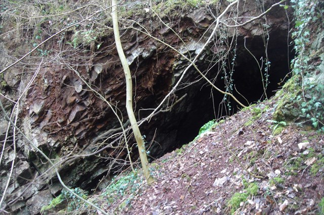
A proximité du paneau se trouve une excavation, à l'intérieur vous trouverez des morceaux de minerai de fer (photo N°5, WP2), prenez en un morceau:
4) vous parait-il lourd ?
5) vous parait-il solide ?
6) tapez le légérement contre le rebord de l'excavation, quelle est la couleur de la trace laissé ?
Enfin, mais optionnel, vous pouvez joindre une photo de vous devant l'excavation.
Loguez cette cache "Found it" et envoyez-moi vos propositions de réponses soit via mon profil, soit via la messagerie geocaching.com (Message Center), et je vous contacterai en cas de problème.
The mining area is a small syncline which extends under the town of Saint-Rémy -sur- Orne.
There are 420 million years, all Normandy is under the sea. At the bottom of her, mud is deposited who, during millennia, are gradually transformed in schists, limestone and sandstone. Some of the latter are loaded in fine iron particles.
In the next period, the movements of continents reveal in the region an enormous mountain: the Hercynian chain. The grounds are folded up, crushed, faulted. The Saint-Rémy site is located in the hollow of a big fold, a syncline.
The enormous work of erosion that takes place over millions of years who following, let just in place the base of this fold, in form of spoon. The deposit of Saint-Rémy is in place, Beaumont and Mont-de-Vespre are the edges of the spoon.
At the coordinates of the earthcache you will find an information panel on the iron mines, I will not dwell here on the operating part to leave you a little discovery on site.
To validate this earthcache, you must answer the 6 following questions:
Theoretical questions (on the panel WP1)
1 - Give me the missing words on the geological cup (Picture No. 4)
2 - There are two forms of iron ore, which are they?
3 - For whom this panel was created ?
Practical issues:
Near the panel is an excavation, inside you will find iron ore pieces (photo No. 5, WP2), take a piece:
4) it seems you heavy?
5) you it seems sturdy?
6) tap it lightly against the edge of the excavation, which is the color of the trace?
Last but optional, you can attach a picture of you in front of the excavation.
You can log this earthcache " Found it " and send me your proposals of answers either via my profile, or via the geocaching.com messaging (Center message), and I shall contact you in case of problem.