The Gnoll Country Park (or Gnoll Estate) is a park in Wales. It is an early-18th-century landscaped garden covering over 100 acres (0.40 km2) in theVale of Neath, South Wales
The park features lakeside and woodland walks, restored formal cascades, a grotto, a coarse fishery, play area, adventure playground and a visitor centre exploring the history and evolution of the estate
As well as this there is a building in the centre, where there is a shop, toilet facility and a cafè. Entry to the park is free of charge, however the council have recently started charging for parking.
Formerly owned by the Mackworth family, there are now only ruins and traces of the glorious house that used to be there.
They often have special events for the children. A bamboo forest is located towards the ruins, this is very popular as the children play in it. There are many well planned traditional geocaches in the park too!
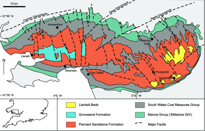
The rocks exposed in Gnoll are a generally southerly dipping succession of Carboniferous age sandstones and mudstones assigned by geologists to the Marros group and formerly referred to as the Millstone grit series
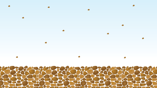
Remember that “the present is the key to the past”. For example, most sandy beds in present day oceans are laid level. There are exceptions, but usually particles such as sand or gravel respond to gravity and fall, rather as particles in muddy water in jam-jar would settle. See the diagram below.
A river or the tide carries, or transports, pieces of broken rock as it flows along. When the river reaches a lake or the sea, its load of transported rocks settles to the bottom. The rocks are deposited. These deposited rocks build up in layers, called sediments. This process is called sedimentation. The weight of the sediments on top squashes the sediments at the bottom. This is called compaction. The water is squeezed out from between the pieces of rock and crystals of different salts form. The crystals form a sort of glue that sticks or cements the pieces of rock together. This process is called cementation. These processes eventually make a type of rock called sedimentary rock. It may take millions of years for sedimentary rocks to form. These are the different processes in order: sedimentation → compaction → cementation
The Neath Disturbance is a geological structure which stretches across South Wales from Swansea Bay northwards and eastwards as far as Hereford in England, it is a consequence of global earth movements.
It consists of a series of both faults and associated folds which were active during the mountain-building period known as the Variscan Orogeny. The Variscan orogeny is a geologic mountain-building event caused by Late Paleozoic continental collision between Euramerica (Laurussia) and Gondwana to form the supercontinent of Pangaea. It is a cataclysmic process in which a section of the earth's crust is folded and deformed by lateral compression to form a mountain ranges. This line of weakness probably featured in the earlier Caledonian Orogeny and perhaps reflects a more ancient line of weakness in the underlying rocks.
The Disturbance gives rise to a lineament crossing the region, that is to say that it is responsible for a number of significant landscape features along its 100 km length.
Prominent amongst these is the Vale of Neath a deep valley incised by a glacier during the ice ages along this line of weakness in the Earth's crust and now occupied by the River Neath between Pontneddfechan and Swansea Bay
The Neath Disturbance is possibly the southernmost geological feature within Britain which can be described as following the Caledonoid trend. The phrase describes a suite of major geological features associated with the closure of the former Lapetus Ocean in the middle Paleozoic Era and giving rise to the Caledonian orogeny.
The rocks here are Carboniferous. This is the middle part of the Paleozoic Era spans from 359 million to 299 million years ago. During this time, average global temperatures were exceedingly high; the early Carboniferous averaged at about 20 degrees Celsius (but cooled down to 10 degrees during the Middle Carboniferous).
Tropical swamps dominated the earth, and the large amounts of trees created much of the carbon for the coal that is used today (hence the name "Carbon-iferous"). These swamps were sporadically flooded by river or the seas, depositing sand and mud compressing the vegetation. Over time, the compressed vegetation forms coal.
Waypoint 1
*Look at the bedding planes in and around the cliff face
Waypoint 2
*Look at the beds exposed here.
DO GO to the coordinates and assess the landscape for yourself. Log the cache, and email or message your response to the following.
IF YOU DO NOT COMPLETE THE LOGGING REQUIREMENT YOUR FIND WILL BE DELETED WITHOUT NOTICE.
(PICTURES ARE WELCOMED BUT please don’t post photos which would allow others to complete the cache from home!!)
LOGGING TASKS
To claim this earth cache.
Refer to the paragraph above about ‘orogeny’ and use your understanding to guide you with your answers.
1. Use you GPS to estimate the change in elevation between the two way points
2. Describe the beds in both places. Estimate the 'dip' or slope of the rocks in degrees (Zero degrees is level and 90 ° would be perpendicular to the ground) What similarities and differences do you see?
3. What may have caused any differences that you see?
4. Just for fun, look inside the rock shelter to find the name of the person who carved it out.
FIRST TO FIND (FTF), HAS TO GO TO BRIGHTON ROB AS HE COMPLETED THE LOGGING REQUIREMENT FOR A "FIND". Profound apologies to an earlier finder, who didn't send the answers.