 La pluie entraîne les plus petites particules dans les cours d’eau, elle fait pénétrer l’eau dans les moindres failles de la roche, en gelant cette eau fait éclater la roche. La pluie favorise le déplacement des éléments chimiques dissous. Les fortes averses de pluie qui font éclater les mottes de terre, trient par gravité les sables et entraînent les particules.
 Les rivières, les torrents de montagne ravinent et déplacent la matière en formant des cônes de déjections, dans les vallées les fleuves déplacent des milliards de tonnes de sable et de sédiments.
L’ensemble des phénomènes mécaniques, biochimiques et physico-chimiques qui cassent, désagrègent, dissolvent et décomposent les roches, se nomme la météorisation.Il est évident que plus les roches sont perméables ou solubles plus elles favorisent les phénomènes de météorisation, à l’inverse les roches quasi-inaltérables tels le quartz sont des roches que seul des mouvement mécaniques liés au mouvement internes de la terre (tectonique), à la sape de la roche encaissante ou à la foudre.
D'un point de vue géologique la Cham des Bondons, où se trouvent de nombreux mégalithes appartient au Causse ............ auquel il est rattaché par un isthme calcaire : le Col de Montmirat.
Cette série sédimentaire jurassique s'appuie sur le socle cristallin du mont Lozère à l'Est et repose sur les micaschistes des Cévennes. Il offre des paysages exceptionnels notamment sur l’Eschino d’Aze et les puechs : buttes témoins où les ........ truffées de fossiles sont protégées par les strates ..........
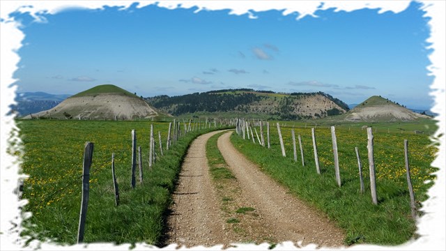
L'Eschino d'Aze est une montagne aux courbes très régulières, alors que les Puechs sont des excentricités naturelles accompagnées de formes généreuses.
Ce massif cristallin, entretenant une secrète alliance avec les causses, héberge sur ses rebords quelques lambeaux de calcaire. Ils sont d'épaisseur et de dimension modestes, mais c'est pourtant là que se cache l'une des grandes grottes de Lozère, et certainement l'une des plus intéressantes : Malaval.
QUESTIONS
1 - Vous êtes ici sur le Causse Méjean, Noir ou de Sauveterre ?
2 - A moins de 5 km derrière l'Eschino d'Azè en fond de vallée coule une rivière célèbre, quel est son nom, où se trouve sa source, vers la droite ou la gauche ?
3 - Quel est le nom de ces deux mamelons situés à 250° nord au premier plan ?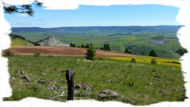
4 - Quelle est la distance en mètres qui sépare les sommets des deux Puechs, 830 m, 860 m, 890 m
5 - Comment se sont formés ces deux mamelons, de quoi sont-ils constitués ?
6 - Identifier sur le terrain notamment au pied du Puech le plus proche les zones de ravinement, décrire la constitution du sol. Une photographie peut être jointe à votre réponse (optionnel).
7 - Outre ces trois spécificités géologiques (les Pechs et l'Eschino d'Azè), quelle est l'autre exceptionnelle particularité archéologique de ce plateau ?
8 - Réaliser (optionnel) une photo de votre GPS avec les deux Puechs et l'Eschino d'Asé en fond.
"Loguez cette cache "Found it" et envoyez-moi vos propositions de réponses soit via mon profil, soit via la messagerie geocaching.com (Message Center), et je vous contacterai en cas de problème."
A bientôt et prenez bien du plaisir sur ce site fabuleux. Goupil30
Carte mégalithes Cham des Bondons Lieux insolites, La cham des Bondons
 The rain washes away the tiniest particles along the rivers, makes the water flow into the tiniest rock faults; when freezing, this water makes the rock burst. The rain favours the shifting of the chemical dissolved elements. The heavy showers which make the clods of earth burst, select the sands through gravity and drag along the particles.
The rivers, the mountain streams furrow and shift the matter forming alluvial cones, in the valleys the rivers shift billions of tons of sand and sediments.
 The whole mechanical, biochemical and physico-chemical phenomena that break, crumble, dissolve and break up the rocks, is called meteorisation.
Obviously, the more permeable or soluble the rocks are, the more they favour the phenomenon of meteorisation.
On the contrary, the quasi-inalterable rocks such like the quartz are rocks that only the mechanical shifts linked to the inner movement of the earth (tectonic), to the sapping of the steep-sided rock or lightning.
From a geological point of view, the Cham des Bondons, where there are numerous megaliths belonging to the Causse ..... which it is related to by a limestone isthmus : the Montmirat Pass.
This sedimentary jurassic set lies on a cristalline bedrock of Mount Lozere in the East and lies on the Cevennes micaschists. It offers exceptional landscapes especially on the Eschino d'Aze and the Puechs : outliers where the .... littered with fossils are protected by the strata ...
The Eschino d'Aze is a very regular-curved mountain, whereas the Puechs are natural eccentricities accompanied with generous forms.
This cristalline massif, bounding a secret covenant with the causses, houses some chalky fragments. There are of modest thickness and dimension, but it is however there that one of the greatest Lozere caves is, and certainly one of the most interesting : Malaval.
QUESTIONS
1 - You are on the Causse Mejean, Black or Sauveterre?
2 - Less than 5 km behind the Eschino Aze in the valley flows the famous river, what's his name, which is its source, to the right or the left?
3 - What is the name of the two nipples located 250 ° north in the foreground?
4 - What is the distance in meters from the tops of two Puechs, 830 m, 860 m, 890 m
5 - How were formed both nipples, what do they consist?
6 - Identify the field including at the foot of the Puech nearest gully areas, describing the constitution of the soil. A photograph can be attached to your answer (optional).
7 - In addition to these three geological characteristics (the Pechs and Eschino AZE), what is the other great archeological feature of this set?
8 - Carry (optional) a picture of your GPS with both Puechs and Eschino of Asé background.
"Phones Sign the cache" Found it "and send me your answers proposals either via my profile or via geocaching.com messaging (Message Center), and I will contact you in case of problems."
Cheers and take good fun on this fabulous site. Goupil30