Roll on, Columbia, roll on.
Your power is turning our darkness to dawn,
Roll on, Columbia, roll on.
In 1941, singer Woody Guthrie wrote a folk song about the mighty Columbia River that still resonates today.
The Columbia River is the 4th-largest river in the United States, and at 1,243 miles, the largest in the Pacific Northwest. The river rises in the Rocky Mountains of British Columbia, flows northwest and south into Washington, then turns west to form most of the border between Washington and Oregon before emptying into the Pacific Ocean. It drains a 260,000-square-mile basin that covers seven states and one province.
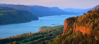
The Columbia and its tributaries have been central to the region's culture and economy for thousands of years, and it's arguably the most significant natural feature in the region. The earliest evidence of human habitation in the river basin dates back 10,000 years. It was an important food source for Native Americans, and thousands would gather on its banks for the annual salmon runs.
In modern times, the river's heavy flow and its relatively steep gradient give it tremendous potential for the generation of electricity - the basis of Guthrie's song. Its 14 hydroelectric dams, plus those on its tributaries, produce over 44% of our country's hydroelectric generation. In fact, with more than 400 dams total, the Columbia River basin is the most hydroelectrically developed river system in the world.
In addition to power generation, the dams have improved river navigation, crop irrigation, flood control, and recreation. The Wenatchee Valley was a desert before water from the Columbia was diverted for irrigation, making our world-class orchards possible.

The river is also a popular recreation area, offering fishing, boating, swimming, waterskiing, windsurfing, and jet skiing opportunities, along with many campgrounds.
Cache site: The cache is located near the boat launch in Entiat City Park, a lovely public space that runs alongside the Columbia River and offers picnicking, boating, fishing, and camping. A paved trail runs along the river and under the nearby bridge - be sure to check out the troll!

This cache was originally part of the 2016-18 Cascade Farmlands GeoRomp, a 12-cache series that showcased the agriculture, recreation, and scenery of north-central Washington, with pathtag prizes for finishers. Each cache had a different theme and highlighted a different community: Leavenworth, Plain, Peshastin, Cashmere, Wenatchee, East Wenatchee, Entiat, Chelan, Manson, Orondo, Waterville, and Quincy.