Na lokaciji ovog EarthCachea pronaći ćete tri zanimljiva geološka fenomena:
vodopad, speleološki objekt i izvor.
Vodopadi
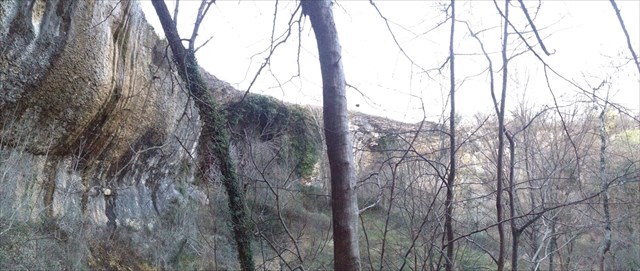
Vodopad je mjesto slobodnog pada vode u toku potoka ili rijeke na mjestima gdje iznenadno dolazi do promjene reljefa. Najčešći uzrok vodopada je različiti litološki sastav dvije stijenske mase, pri čemu je stijenska masa nizvodno mekša i manje otporna na riječnu eroziju, nego što je to u uzvodnom bloku.
Vodopadi se najčešće formiraju na gornjem toku rijeke. U tom djelu kanal toka je uglavnom uzak i dubok. Kada rijeka teče po čvršćim stijenama erozija se događa polako, a kada teče po mekšim stijenama erozija se odvija mnogo brže. Na taj način stvara se visinska razlika između dva dijela toka rijeke i vertikalni pad, a protokom vode preko vertikalnog pada stvara se vodopad.
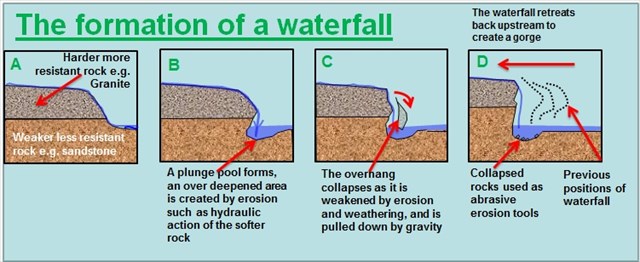
Ispod čvrstog sloja stijena često se nalazi mekši sloj koji će se pod stalnim utjecajem kapljica vodopada izdubiti u oblik plitke špilje što može izgledat kao stjenoviti zaklon ispod i iza vodopada. Što se više ispire mekši sloj stijena, povećava se mogućnost da se vrh tvrđih stijena uruši pod vlastitom težinom. U tom slučaju blokovi stijena padaju na dno vodopada, te se razbijaju u manje komade, koji nadalje dodatno produbljuju bazen vodopada procesom abrazije.
Speleološki objekti
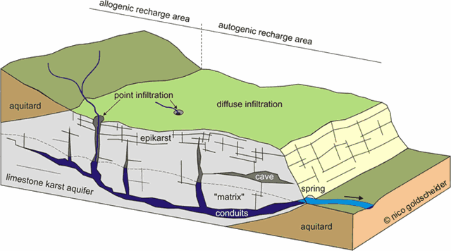
Speleološki objekti su podzemne šupljine nastale prirodnim putem koje su dovoljno velike da u njih može ući čovjek. Razlikuju se špilje i jame.
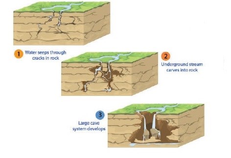
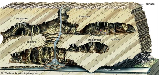
Špilje su podzemne šupljine koje su razvijene u vodoravnom pravcu (do 45° ). Špilje su otvorenim dijelom u izravnom kontaktu spojene s površinom. Pružaju se vodoravno u podzemlje (manje od 45°). Vrlo vjerojatno nastaju cirkulacijom vode ispod razine podzemne vode. Špilje karakteriziraju različite vrste taloga od kojih su najzanimljivije sige, koje su značajne zbog istraživanja klimatskih promjena u geološkoj prošlosti. Upravo sige nastaju procesom suprotnim otapanju, odnosno taloženjem.
Jame su podzemne šupljine koje su razvijene u okomitom pravcu. Jame su također otvorenim dijelom u izravnom kontaktu s površinom. Pružaju se pod kutom većim od 45° u podzemlje. Kao vertikalni kanali spuštaju se duboko u stijenski masiv pa predstavljaju najmoćniji kontaktni sustav kroz koji voda prodire u krško podzemlje.
Izvori
Izvori su mjesta pojavljivanja podzemne vode na površini, ovisno o prirodnim karakteristikama stijena i lokalnim hidrogeološkim odnosima. Izvori se često nalaze na nagibima gdje dolazi do sjecišta površine Zemlje i vodne plohe, što omogućava podzemnoj vodi da istječe na površinu.
Vodna ploha je granica između gornjeg nezasićenog područja (zona aeracije ili vadozni pojas) i donjeg zasićenog područja (zona saturacije).
Prozračna zona ili zona aeracije je prostor ispod površine pa sve do vodne plohe. Kroz ovu zonu prolazi voda s površine koja napaja podzemnu vodu. Dio tih voda ostaje zadržan u prozračnoj zoni molekularnim i kapilarnim silama - talna i kapilarna voda. Ako je vodna ploha toliko duboko ispod površine da kapilarna voda ne doseže do talne vode, između njih postoji međupojas, odnosno vadozna zona, kroz koju se povremeno procjeđuje voda s površine u podzemlje.
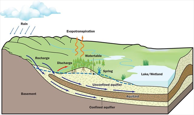
Zasićena zona ili zona saturacije je zona ispod vodne plohe u kojoj su sve pore i pukotine u stijenama ispunjene vodom. Ovu vodu nazivamo podzemna voda ili voda temeljnica. Dakle, gornju granicu podzemne vode čini vodna ploha ili vodno lice = razina vode u zdencima ili bunarima.
Da bi mogli logirat Earthcache postavit ću Vam nekoliko pitanja, a Vi mi pošaljite odgovore na mail, ne morate čekat moj odgovor već slobodno logirajte, ako nešto nije u redu kontaktirat ću Vas.
1. Promotrite dva sloja stijena bitna za nastanak vodopada. Koji je sloj deblji; sloj tvrđe stijene ili sloj mekše stijene?
2. Promotrite nagib u speleološkom objektu. Je li ovdje rijeć o špilji ili o jami? Objasnite zašto?
3. Istražite lokaciju earthcachea. Gdje se nalazi mjesto na kojem vodena ploha siječe površinu; unutar speleološkog objekta ili izvan njega?
4. Napravite fotografiju sebe (fotografijom na kojima je gps/mobitel, ruka ili noga NE ispunjavate zadatak i log će biti obrisan) ili papira s vašim nikom sa lokacije EC-a te ju stavite u svoj log
Opustite se i uživajte na ovom predivnom mjestu!

At the location of this EarthCache, you will find three interesting geologic phenomena:
Waterfall, speleological object and spring.
Waterfalls
Waterfall is a location where water is falling free in the course of a stream or river. It happens at the locations of a sudden change in relief. The most frequent causes of waterfalls are differences in lithological characteristics of two rocks. Rocks in the lower course are softer and less resistant to river erosion when compared to the rocks in the upper course.
Waterfalls are usually formed in the upper course of the stream or river. In that part of the course the channel is often narrow and deep. When the river flows over harder rocks, erosion happens slowly, and when the river flows over softer rocks, erosion occurs more rapidly. This creates the height difference between two parts of the course of a river and there is a vertical drop. The waterfall is formed when a stream or river flows over that vertical drop.
Softer layer of rocks is often located bellow the harder layer of rock. The splashback of water drops will undercut the softer layer of rock and it will form a cavity that looks like shallow cave or rock shelter behind and bellow waterfall. As the softer rock layer is more undercut, the higher is chance that the upper, harder rock layer collapses under its own weight. When that happens, blocks of rock fall down to the base of the waterfall and then they are broken down into smaller pieces. These smaller pieces additionally erode the waterfall’s plunge pool with the process of abrasion.
Speleological objects
Speleological objects are naturally formed underground cavities that are large enough for human to enter inside them. They can be caves or pits.
Caves are underground cavities with horizontal direction (up to 45°). Caves have direct contact with the surface with their opening. They extend horizontally into underground (less than 45°). They form when water circulate bellow level of groundwater. Caves are characterized by different types of deposits, the most popular of them are dripstones. Dripstones are important for their role in researches of climate changes in geological history. Dripstones are formed by process that is opposite to melting, ie. by precipitation.
Pits are underground cavities that are developed in vertical direction (45°- 90°). Pits also have direct contact with the surface with their opening. The angle of their extension towards underground is larger than 45°. As vertical channels they descend deeply into rock massif, and they represent contact system through which water penetrates into karst underground.
Springs
Springs are locations where groundwater flows out onto the surface. It is determined by the characteristics of the rocks and by local hydrogeologic characteristics. Springs are often located on slopes where water table intersects with the surface, and that enables groundwater to flow out on the surface.
Water table Water table is the boundary between the upper, unsaturated zone (zone of aeration) and the lower, saturated zone (zone of saturation).
Zone of aeration Zone of aeration is the area that extends bellow surface and all the way down to the water table. Water moves through this zone and becomes groundwater. Part of this water stays in the zone of aeration thanks to molecular and capillary forces, and it is called capillary water. If the water table is deep below the surface and capillary water can’t reach the groundwater, between the water table and zone of aeration there is also a zone called capillary fringe area.
Zone of saturation is area bellow the water table. All cavities in this area are filled with water. This water, within zone of saturation is called groundwater. So, upper boundary of groundwater is represented with the water table. It is also the level of water within wells.
In order to log this EarthCache I will ask you several questions and you should send your answers to my e-mail. You don’t have to wait for my confirmation, feel free to log the find as soon as you send your answers. If there are problems with your answers, I will contact you.
1. Observe two rock layers that are important for waterfall formation. Which layer is thicker; layer of harder rock or layer of softer rock?
2. Observe the slope in speleological object. Is this speleological object a cave or a pit? Explain why?
3. Explore the location of this EarthCache. Where does water table intersects with the surface; inside the speleological object or outside?
4. Make a photo of yourself (photo showing a GPS/mobile phone, hand or leg do NOT fulfill the task and the log will be deleted) or paper with your nick from the location of the EC and put it to the log.
Relax and enjoy this beautiful location!

An der Stelle dieses Earthcaches befinden sich drei interessante geologische Phänomene:
Wasserfall, Speläologisches Objekt und Quelle.
Wasserfälle
Wasserfall ist ein Ort, wo es zum freien Fall des Wassers im Laufe eines Bach oder Flusses kommt, wegen der plötzlichen Veränderung des Reliefs. Die häufigste Ursache für den Wasserfall ist anders lithologischen Zusammensetzung zweier Gesteinsmassen, wo die Gesteinsmasse stromabwärts weicher und weniger resistent gegen Flusserosion ist, als im stromaufwärts-Block.
Wasserfälle bilden sich häufig im oberen Lauf des Flusses. In diesem Teil ist der Kanal oft schmal und tief. Wenn der Fluss fließt durch feste Felsen Erosion geschieht langsam, aber wenn er durch das weichere Gestein läuft erfolgt die Erosion viel schneller. Auf diese Weise schafft die Höhendifferenz zwischen zwei Teilen des Flusses ein vertikalen Fall und die Strömung von Wasser über den vertikalen Fall einen Wasserfall.
Unter der Schicht aus festem Gestein ist oft eine weichere Schicht, die unter dem ständigen Einfluss der Tropfen des Wasserfalles eine flache Höhle aushöhlen wird, die unter und hinter dem Wasserfall wie ein Zuflucht Felsen aussehen kann. Je mehr sich die weichere Schicht von Felsen spült, ist die Möglichkeit höher, dass das obere härtere Gestein unter seinem eigenen Gewicht zusammenbricht. In diesem Fall fallen Blöcke von Steinen auf dem Boden des Wasserfalls, und zerlegen sich in kleinere Stücke, die noch weiter den Wasserfall Poll im Prozess der Abrasion vertiefen.
Speläologischen Objekte
Speläologischen Objekte sind unterirdische Hohlräume die natürlich entstanden sind, und die groß genug sind das ein Menschen sie betreten kann.. Man unterscheidet Höhlen und Schachthöhle.
Höhlen sind auch mit offenem Teil in direktem Kontakt mit der Oberfläche verbunden, aber gehen horizontal in die Untererde (weniger 45 °). Möglicherweise entstehen sie durch umlauf des Wasser unter dem Niveau der Unterirdischen Wassers. Die Höhlen sind durch verschiedene Arten von Ablagerungen gekennzeichnet, von denen die interessanteste speleothems, die für die Erforschung des Klimawandels in der geologischen Vergangenheit wichtig sind. Sinter das durch eine allmähliche mineralische Ablagerung entsteht insbesondere eine Kalkablagerung.
Die Schachthöhle ist offen teilweise in direktem Kontakt mit der Oberfläche. In einem Winkel von mehr als 45 ° unter der Erde. Als vertikale Kanäle tief in den Felsmassiv absteigen, sie darstellen das stärkste Kontaktsystem durch die das Wasser dringt in den Karst Untergrund.
Quelle
Eine Quelle ist ein Ort wo das Grundwasser auf die Oberfläche austritt, es hängt von den natürlichen Eigenschaften der Gesteine ab und den lokalen hydrogeologischen Verhältnis. Die Quellen befinden sich oft an Hängen wo es zur Schnitt der Erdoberfläche und der Wasseroberfläche kommt, was das austreten des Grundwasser an die Oberfläche ermöglicht.
Die Grenze zwischen der wasserungesättigten Zone und der wassergesättigten Zone wird als Grundwasseroberfläche bezeichnet.
Das Wasser dringt zunächst in eine Sediment- oder Bodenschicht ein, die als Wasserungesättigte Zone bezeichnet wird. Durch diese Zone gelangt das Wasser von der Oberfläche, die durch das Grundwasser gespeist. Teil dieses Wassers wird in der Wasserungesättigte Zone durch Molekular- und Kapillarwirkung zurückgehalten.
An einem gewissen Punkt erreicht das Wasser eine Zone, in der die Hohlräume zwischen den Sedimentpartikeln mit Wasser anstatt mit Luft ausgefüllt sind – die wassergesättigte Zone. Dieses Wasser ist das Grundwasser. Es macht die obere Grenze des Grundwasseroberfläche oder Grundwasserspiegel = Wasserstand in den Brunnen.
Zum Logen dieses Earthcaches habe ich für Sie ein paar Fragen. Bitte die Antworten auf mein E-mail Adresse schicken. Sie müssen nicht auf meine Antwort warten, sondern können gleich Loggen, wenn was nicht korekt ist werde ich Sie kontaktieren.
1. Betrachten Sie die beiden Schichten von Felsen die wichtig für die Bildung von Wasserfällen sind. Welche Schicht ist dicker ; Schicht aus härterem Gestein oder Schicht aus weichem Gestein?
2. Betrachten Sie die Steigung beim Speläologischen Objekte. Ist es eine Höhle oder einer Schachthöhlen? Erklären Sie, warum?
3. Erkunden Sie den Ort des Earthcaches. Wo ist der Ort, an dem die Grundwasseroberfläche die Oberfläche schneidet; innerhalb Speläologischen Objekte oder außerhalb?
4. Mache ein Foto von sich selbst (Foto das ein GPS/Handy, Hand oder Bein zeigt, erfüllen NICHT die Aufgabe und werden gelöscht)oder Papier mit Ihrem Nick an der Lokation des EC und bitte das Foto zum Log hohladen.
Entspannen und genießen Sie diesen wunderbaren Ort!
Izvor:
Alecia M. Spooner : Grundlagen der Geologie für Dummies
Alecia M. Spooner, Geology for Dummies, Hoboken: Wiley Publishing, Inc., 2011.
Dunja Aljinović & Bruno Tomljenović: Površinska i podzemna voda (2.dio)
Wikipedia
Coolgeography.co.uk
Suradnja sa GC Edo je neprocjenjiva, veliko hvala na pomoći, podršci i strpljenju!
Souvenir/Banner:
Code: <a href="http://coord.info/GC6G3AD" ><img src="https://s3.amazonaws.com/gs-geo-images/4a5476b0-41d8-4af3-99ba-0bc7100ed9bf.png" /></a>