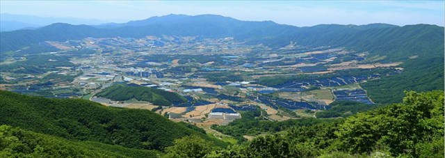
Punch Bowl in Yanggu-gun, Gangwon-do is a highland basin situated 400-500 meters above sea level. The area is surrounded by Mountain Daeam(1,304 m), Mountain Dosol(1,148 m), Mountain Daewoo(1,179 m). All the water streams from the mountains flow into Seohwa-myun, Inje-gun.
Geology
Punch Bowl is one of the most representative erosion basins in South Korea, which was formed as a result of differential weathering and erosion on rocks. The area was originally composed of sedimentary rocks. But during the Jurassic period in the Mesozoic era(about 120 million to 180 million years ago),the magma intruded into bed rock, sedimentary rock, which had been formed during Pre-Cambrian period(about 4,600 million years ago) and made a big granite rock in the center of the basin.
Sedimentary rock above the granite rock received high levels of heat and pressure from granite intrusion. The metamorphosed sedimentary rocks changed into metasedimentary rocks that are strong against erosion. In contrast, granite rock deep underground became weak against erosion with the weathering and decreased pressure from the above.
Among two types of rocks that moved up above the surface, the metasedimentary rock, which became relatively strong against erosion, formed the mountainous area, while the granite that was weak against the erosion formed the low and flat surface.
Erosion
Erosion corresponds to all external phenomena at the soil surface or at shallow depths, remove all or part of existing land and thus modify the terrain. There are two main types of phenomena which, in most cases, the effects are additive:
Chemical erosion : chemical processes with weathering and dissolution by water more or less charged with carbon dioxide. These phenomena dominate, for example, in the formation of karst features.
Physical or mechanical erosion : physical or mechanical processes with weathering of rocks and debris removal by a fluid, where the distinctions between wind erosion, fluvial, glacial, marine.
Chemical erosion removes approximately 6 mm / 1000 years to the surface of the continents, mechanical erosion ten times. This average across the Earth because erosion rates vary widely from one area to another, depending on the climate and landforms.
[How to log]
1. What are the type of phenomena involved in erosion on the cache zone?
1) Chemical erosion
2) Physical or mechanical erosion
3) Both
2. Geologically which area was formed earlier?
1) Mountain area
2) Basin area
3. There is a plaque explaining about a Greetingman on which names of two men are carved at the cache zone. What are those names?
4. Taket a picture of you holding your GPSer in hand with Greetingman in the background.(The task is optional but I would highly appreciate if you would do so.)
5. Please send the answers to me by message on my profile! If the answer is not correct, I will contact you.

펀치볼 분지는 대암산(1,304 m), 도솔산(1,148 m), 대우산(1,179 m)으로 둘러 싸여 있으며, 동서 거리는 8.5 km, 남북은 7 km, 분지 바닥의 평균 표고는 400~500 m의 거의 완벽한 원을 그리고 있다 해안면의 물은 인제군 서화면으로 빠져나간다
지질학적 특징
펀치볼은 암석의 차별풍화, 침식에 의해 형성된 우리나라의 대표적인 폐쇄형 분지이다. 원래 이 지역은 46억년전 선캄브리아기에 생성된 퇴적암류로 이루어져 있었으나, 중생대 쥐라기(약 1.8억년~1.2억년 전)때 화강암이 관입하면서 높은 열과 압력을 받았다. 변성작용을 받은 퇴적암류는 침식작용에 강한 변성퇴점암류로 변하였다. 반면, 지하 깊은 곳에서 관입한 화강암은 오랜 시간 지하에서 풍화작용(심층풍화)을 받고 위로부터의 압력이 약해짐에 따라 침식작용에 약한 상태가 되었다. 이후 지표에 드러난 두 암석 중 상대적으로 침식작용에 강해진 변성퇴점암류는 주변 산지를 이루고, 풍화물질이 제거되고 침식작용이 활발하게 일어난 화강암은 낮고 평평한 분지 바닥을 이루게 되었다.
침식의 종류
침식은 토양의 표면 또는 토양 아래 얕은 부분에서 토양의 전체 또는 일부가 제거되며 지형을 변화시키는모든 외부현상을 말한다. 침식은 크게 2종류로 나뉘는데, 대부분의 경우 2가지 효과가 같이 나타난다.
화학적 침식 : 이산화탄소가 어느정도 가미된 물에 의해 일어나는 풍화와 용해의 과정을 말한다.이현상은 예를 들면 카르스트지형에서 두드러지게 나타난다.
물리적 또는 기계적 침식 : 유동체에 의한 바위나 파편의 풍화의 과정을 말한다. 바람에 의한 침식, 하천에서의 침식, 빙하침식, 바다에서의 침식등이 이에 속한다.
화학적 침식은 대략 1000년에 6mm 깍이고, 물리적 또는 기계적 침식은 10배정도 더 빨리 진행된다. 물론 침식은 지역에 따라 또는 기후나 지형에 따라 큰 차이가 나기 때문에 이는 지구상에서 일어나는 비슷한 유형의 침식의 평균일 뿐이다.
[로그하는 방법]
1. 캐시존에 어떤 유형의 침식이 일어났습니까?
1) 화학적 침식
2) 물리적 또는 기계적 침식
3) 2가지 침식 모두
2. 지질학적으로 관찰할 때 다음의 지역중 어느 것이 먼저 형성되었을까요?
1) 산악지형
2) 분지
3. 캐시존에 가면 그리팅맨이 있습니다. 그 앞에는 그리팅맨에 대해 설명하는 돌로 된 안내판이 있습니다. 그 안내판에 새겨진 2명의 이름은 무엇인가요?
4. 그리팅맨을 배경으로 GPSer를 든 당신의 사진을 찍어 로그에 올려주세요.(선택사항이지만 사진을 올려주시기를 부탁드립니다.)
5. 문제 1 ~ 3의 답을 캐시 오너에게 Profile에서 메세지로 보내주세요. 답에 문제가 있으면 회신해 드리겠습니다.
Congrats to Jiho Kim for FTF!
| I have earned GSA's highest level: |
 |