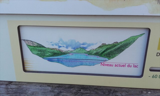
Le lac d'Annecy, parfois surnommé le "lac bleu", est un lac de France situé dans les Alpes, en Haute-Savoie. Par sa superficie il est le deuxième lac d'origine glaciaire de France après celui du Bourget, exception faite de la partie française du lac Léman.

Il est encadré à l'Est par le massif des Bornes et à l'Ouest par le massif des Bauges, au Nord par l'agglomération d'Annecy et au sud par la vallée vers Faverges qui prolonge Le-bout-du-lac. Le lac à une superficie de 27.59 km², pour une longueur de 14.6 kilomètres et une largeur de 3.35 kilomètres. Il est situé à une altitude de 446.69 mètres.
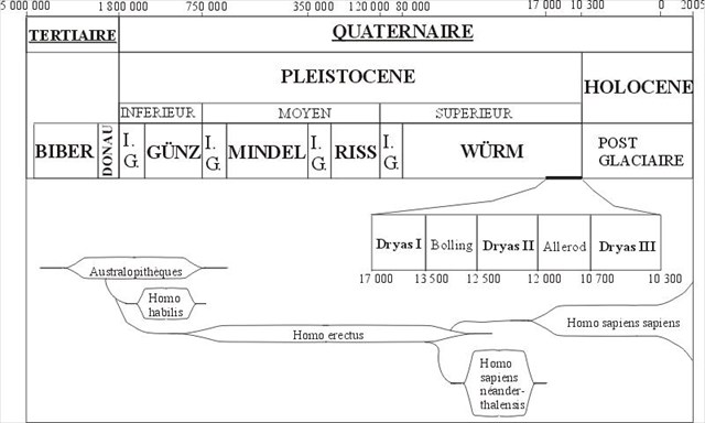
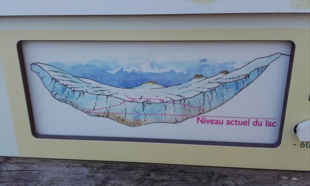
Le lac s'est formé vers la fin de la quatrième période glaciaire, dite glaciation de Würm, au moment de la fonte des grands glaciers alpins.
Un lac glaciaire est un lac qui occupe un creux résultant de l'érosion par un glacier. Un glacier en recul laisse souvent des blocs de glace, dans des cavités entre les drumlins ou les collines. A la fin de la période glaciaire, cette glace fond pour former des lacs.
Cependant, ces lacs existent aussi avant la disparition du glacier. Ils sont là aussi issus de la fonte de ce dernier. Ils peuvent être sous glaciaires, coincé entre le glacier et sa moraine frontale, ou encore sur-glaciaire, coincé en amont par la roche et le glacier lui-même.
A noter que la plupart des lacs alpins, sont des lacs d'origine glaciaire, comme le lac léman ou le lac de Zurich.
Questions:
Sur place vous trouverez un panneau d'information, répondez aux questions suivantes:
1 - D'où part le glacier à l'origine du lac d'Annecy et jusqu'à quel endroit et s'étend t-il ?
2 - A cette époque, Le-bout-du-lac est sous combien de mètres de glace ?
3 - Après la fonte des glaces, un lac deux fois plus grand que l'actuel se forme, mais c'était il y a combien d'année ?
4 - Pour valider votre passage, donnez-moi le nom de l'édifice se trouvant juste à côté des coordonnées de cette earthcache.
Enfin, mais optionnel, vous pouvez joindre une photo de vous devant le lac.
Loguez cette cache "Found it" et envoyez-moi vos propositions de réponses soit via mon profil, soit via la messagerie geocaching.com (Message Center), et je vous contacterai en cas de problème.

The Lake of Annecy, sometimes nicknamed the " blue lake ", is a lake of France situated in the Alps, in the Haute-Savoie. By its surface it is the second lake of glacial origin of France after that of Bourget, exception made by the French part of the Lake Léman.
It is framed in the East by the massif of Bornes and on the West by the massif of Bauges, in the North by the urban area of Annecy and in the South by the valley towards Faverges who extends Le-bout-du-lac. The lake have a surface of 27.59 km², for a 14.6 kilometer length and a 3.35 kilometer width. It is situated at a 446.69 meter height.
The lake has been formed towards the end of the fourth glacial period, say glaciation of Würm, at the moment of the melt of the big alpine glacier.
A glacial lake is a lake which occupies a hollow resulting from the erosion by a glacier. A declining glacier often leaves blocks of ice, in cavities between drumlins or hills. At the end of glacial period, this ice melts to form lakes.
However, these lakes also exist before the disappearance of the glacier. They are also the result of the melts of the glacier. They can be under glacial, stuck between the glacier and its frontal moraine, or still on the glacier, stuck upstream by the rock and the glacier himself.
To note that most of the alpine lakes, are lakes of glacial origin, as the Lake Léman or the lake of Zurich.
Question:
On the spot you will find an information board, answer the following questions:
1 - Where is the departure of the glacier at the origin of the Lake Annecy and intil where it extends ?
2 - At that time, Le-bout-du-lac is under how many meters of ice?
3- After the melts of ices, a lake forms twice as big as a current size , but it was how much year ago?
4 - To validate your passage, give me the name of the building being just next to the coordinates of this earthcache.
Finally, but optional, you can join a photo of you in front of the lake.
You can log this earthcache " Found it " and send me your proposals of answers either via my profile, or via the geocaching.com messaging (Center message), and I shall contact you in case of problem.