La Earthcache / The Earthcache
L'île de Ré correspond à l'extrémité nord-ouest de la grande auréole sédimentaire nord-Aquitaine. C’est sur les assises d’un socle calcaire de l'Oxfordien supérieur et du Kimméridgien que s’appuie cette île de l’Atlantique.
A partir de ce socle de l'ère secondaire, la physionomie de l'île paraît déterminée par trois facteurs essentiels : les dislocations tectoniques tertiaires, puis l'importance de l'érosion marine et continentale durant le Quaternaire, enfin le colmatage des dépressions par le "bri" et l'ensablement de la plate-forme calcaire lors de la transgression flandrienne.
► Contexte géologique local
D’après la carte du BRGM, toute la partie centrale du Nord de l’île de Ré est occupé par une couche MFyb – « Alluvions marines et fluvio-marines », appelé aussi argiles brunes à scrobiculaires (bri récent).
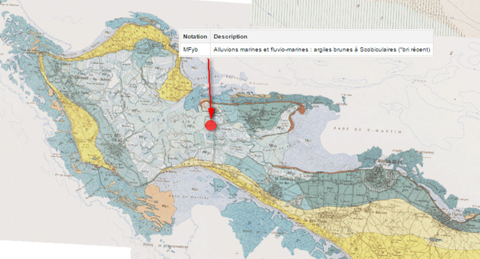
On désigne localement sous le nom de bri une assise argileuse extrêmement lourde et pratiquement dépourvue de sables grossiers et de graviers.
Son origine marine est prouvée par la présence de coquilles très bien conservées de Scrobicularia plana, Cardium edule et Ostrea edulis, faune vivant actuellement dans les vases de l'anse de l'Aiguillon. Il s'agit d'une argile brune, toujours calcaire.
► Le bri marin, témoin d’une histoire rétaise récente
Formés au niveau de son socle par des plateaux calcaires datant du Jurassique supérieur, l'île (ou plutôt les îles) de Ré a longtemps connu plutôt un phénomène d'érosion que de sédimentation, particulièrement pendant la dernière période glaciaire datant de -20 000 ans, ce qui en résulte une grande lacune d'observation avec les couches plus récentes (absence de couches tertiaires).
Ces intenses phénomènes d'érosion de la roche calcaire et marneuse du début du Quaternaire ont entraîné un bouleversement de la mophologie des côtes rochelaise, dont l'île de de Ré n'est qu'une avancée, entraînant la formation de vastes dépressions.
Suite à la fin de la dernière grande glaciation, le réchauffement planétaire va entraîner sur les 10 000 dernières années une forte montée des eaux qui vont envahir ces dépressions, notamment le vaste espace creusé entre les éperons calcaires de ce qui va devenir les 4 îles de Ré : Ars, Loix, Les Portes et Saint Martin-La Flotte.

Cette forte immersion va permettre le dépôt d'argile marine à Scrobiculaires sur une épaisseur moyenne de 10 mètres pouvant atteindre 30 mètres. Actuellement, la moitié nord-ouest de l'île est occupée pour au moins 50 % de sa superficie par des marais à bri marin répartis autour du fier d'Ars et de la fosse de Loix.
► Puis vinrent les marais salants…
Profitant de la présence de ce bri marin, les hommes ont décidé d’utiliser les caractères de ces sédiments (terrains imperméables et plats situés au niveau de la mers), et les conditions climatiques particulières (vents forts et réguliers, soleil ardent et pas de pluies en été) pour mettre en place la production du sel marin dès le XIIIème siècle.
Le marais salant est, en réalité, un grand évaporateur solaire ou "vents et soleil" conjugués vont permettre d'évaporer l'eau de mer pour concentrer puis faire cristalliser le sel.
Cette tranformation se fait sur plusieurs étapes dans différents compartiments du marais salant :

- La décantation : l’eau de mer passe dans le vasais, avec une concentration initiale d'environ 28 grs de sel par litre.
- La concentration : l’eau circuler très lentement dans la métière puis les tables courantes par gravitation. Le soleil et le vent (vent sec) commencent à évaporer cette eau qui termine cette étape à une concentration de 100 grs de sel par litre.
- La cristalisation : L’eau de plus en plus salée va finalement aboutir dans les muants (180 grs/l). L'eau des muants, qui est devenue une saumure, va alimenter les nourrices qui va nourrir l'aire saunante en saumure ; et c'est simplement lorsque l'eau atteindra les 260 grs de sel par litre que l'on verra le chlorure de sodium (NaCl) se cristalliser, et que le sel pourra être récolté par le saulnier (appelé aussi paludier).
The island of Ré is the northwest end of the large sedimentary halo North Aquitaine. It is on the foundation of a limestone base of the Upper Oxfordian and Kimmeridgian that uses this Atlantic's island.
From this base of the Mesozoic era, the island's physiognomy appears determined by three key factors: tertiary tectonic dislocations and the importance of marine and continental erosion during the Quaternary finally clogging depressions by brown marine clay at the Flandrian transgression.
► Geographical and geological context
According to the geological map, all the central northern part of the island of Ré is occupied by a layer MFyb - "marine alluvium and river-sea", also called brown clays with scrobiculaires.
Locally is referred to as bri an extremely heavy clay base and substantially free of coarse sand and gravel.
Its marine origin is proven by the presence of well-preserved shells Scrobicularia plana, Cardium edule and Ostrea edulis, wildlife currently living in the vessels of the loop of l'Aiguillon. This is a brown clay, limestone still.
► Brown marine clay, witnessed of the history of Ré
Formed at its base by limestone plateaus dating from the Upper Jurassic, the island (or rather the islands) of Re has long been a phenomenon of erosion rather than sedimentation, especially during the last glacial period dating from 20 000 years, which results in a large gap observation with the most recent layers (non-tertiary layers).
These intense erosion of limestone rock early Quaternary led to a disruption of the Rochelle mophologie coastline, the island of Re is an advanced, causing the formation of large depressions.
Following the end of the last ice age, global warming will result in the last 10 000 years strong rising waters that will invade these depressions, including the vast space opened between the limestone spurs of what will become the 4 islands Re: Ars, Loix, Les Portes and Saint-Martin La Flotte.
This sharp dip will allow the marine clay deposit Scrobiculaires on an average thickness of 10 meters up to 30 meters. Currently, the eastern half of the island is occupied at least 50% of its area by bri marine marshes distributed around the pride of Ars and pit Loix.
► Then came the salt marshes ...
Taking advantage of the presence of this sea bri, men have decided to use the characters of these sediments (waterproof and flat land located at the sea), and the particular climatic conditions (strong and steady winds, hot sun and no rains in summer) to set up the production of sea salt from the thirteenth century.
The salt marsh is in reality a large solar evaporator or "wind and sun" conjugates will allow to evaporate seawater to concentrate and crystallize the salt.
This tranformation is done on several stages in various compartments of the salt marsh:
- Concentration: water circulates very slowly in the current tables then in métières by gravity. The sun and wind (dry wind) begin to evaporate the water that ends this step at a concentration of 100 grams of salt per liter.
- The crystallization: water increasingly salty will ultimately result in muants (180 gr / l). Water from muants, which became a brine, the nurses will fuel that will feed the saunante area in brine; and this is just when the water reaches the salt of 260 gms per liter as discussed sodium chloride (NaCl) to crystallize, and the salt may be collected by the saulnier (also called paludier).
► Sources bibliographiques / Bibliographical sources
Les Questions / The Questions
La lecture attentive du descriptif de la cache, ainsi qu'une observation des éléments de terrain et un peu de déduction sont normalement suffisants pour répondre aux questions de cette EarthCache.
A careful reading of the description of the cache, as well as observation of terrain features and some deduction is usually sufficient to answer questions of this EarthCache.
Questions pour valider :"Géol’Ré : Du bri marin aux marais salants"
Questions to validate: "Géol’Ré - : From brown marine clay to salt marshes"
Point 1 : N 46° 13.234 W 001° 27.506
Vous voici devant le bâtiment de l'écomusée du marais salant.
You are in front of the building of the museum of salt marsh.
- Question 1 : Un symbole se trouve sur le mur ; ce quoi s'agit-il ? Expliquer son importance pour la cristallisation du sel.
- Question 1 : A symbol is on the wall; What is this about? Explain its importance to salt crystallization.
Point 2 : N 46° 13.213 W 001° 27.526
Vous voici maintenant devant plusieurs compartiment d'un marais salant.
You are now in front of several compartment of a salt marsh.
- Question 2 : Quel est le nom du compartiment au premier plan ? Quel est son rôle dans le processus de cristalisation du sel ?
- Question 2 : What is the name of compartment to the forefront? What is its role in the crystallization of the salt process?
- Question 3 : Quel est le nom du compartiment au second plan ? Quel est son rôle dans le processus de cristalisation du sel ?
- Question 3 : What is the name of compartment in the background? What is its role in the crystallization of the salt process?
Point 3 : N 46° 13.197 W 001° 27.571
Descendez avec prudence sur la plate-forme de la photo ci-dessous.
Descend cautiously on the platform of the photo below.
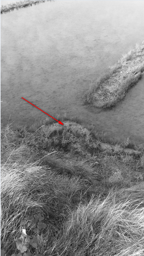
- Question 4 : Prenez entre vos doigts un peu de matière du sol sous vos pieds. Décrivez la texture de ce sol, sa couleur, sa granulométrie. De quoi s'agit-il ?
- Question 4 : Take your fingers a little matter of the soil under your feet. Describe the texture of the soil, its color, size. What is it about ?
Vous pouvez vous loguer sans attendre notre confirmation,
mais vous devez nous envoyer les réponses en même temps soit par mail via notre profil (
fafahakkai), soit via la messagerie geocaching.com (Message Center).
S'il y a des problèmes avec vos réponses nous vous en ferons part.
Les logs enregistrés sans réponses seront supprimés.Une photo de vous ou de votre GPS en Noir & Blanc avec les marais salants en arrière plan (hors Waypoints) sera la bienvenue, mais n'est pas obligatoire.
You can log this cache without waiting for our confirmation, but you must send us the answers at the same time, by e-mail via our profile (fafahakkai) or by the system of Message Center of geocaching.com.
If there is a problem with your answers we will notify you. The logs recorded without answers will be deleted.
A picture of yourself or your GPS in Black and White (and NOT Waypoints) with the salt marshes in the background would be welcome but is not mandatory.
Rappel concernant les « Earthcaches »: Il n'y a pas de conteneur à rechercher ni de logbook à renseigner. Il suffit de se rendre sur les lieux, de répondre aux questions ci-dessus et de nous renvoyer les réponses.
Reminder concerning "Earthcaches": there is neither a container to look for nor a logbook to sign. One need only go to the location, answer to the differents quiestions and send us the answers.