Skip to content

The Sandbar of Bugio EarthCache

Hidden : 1/25/2016
Difficulty:
1.5 out of 5
Terrain:
3.5 out of 5

Size: Size:   other (other)

Join now to view geocache location details. It's free!

Watch

How Geocaching Works

Please note Use of geocaching.com services is subject to the terms and conditions in our disclaimer.

Geocache Description:


O Forte de São Lourenço do Bugio / The Fort of São Lourenço do Bugio

O Forte de São Lourenço do Bugio

O Forte de São Lourenço do Bugio, também conhecido como Forte de São Lourenço da Cabeça Seca ou simplesmente Torre do Bugio, localiza-se a meio das águas da foz do rio Tejo, na direção da Cova do Vapor, Trafaria (que fica a Norte no Distrito de Setúbal) e da vila e concelho de Oeiras (que fica a Sul no Distrito de Lisboa), em Portugal. Inclui na sua estrutura o Farol do Bugio.

O local onde se ergue é um banco de areia formado pelo assoreamento da foz do rio, fruto da dinâmica da confluência de suas águas com as do oceano Atlântico, ao ritmo das marés. Sendo o único da região com a superfície acima da linha de marés durante todo o ano, ficou-lhe a toponímia de cabeço ou cabeça seca.

The Fort of St. Lawrence of Bugio

The Fort of St. Lawrence of Bugio, also known as Forte de St. Lawrence of the “Dry Head” or simply Bugio Tower, is located in the midst of the waters of the mouth of the Tagus River, in the direction of Cova do Vapor, Trafaria (which is North in the district of Setúbal) and the town and county of Oeiras (which is in the Southern District of Lisbon) in Portugal. It includes in its structure the Lighthouse Bugio.

The place where it stands is a sandbar formed by the silting of the river mouth, due to the dynamics of the confluence of the waters with the Atlantic Ocean, to the rhythm of the tides. The only region with the surface above the tide line all year got her the names of hillock or dry head.

A morfodinâmica da região das barras do Tejo / The morphodynamics of the bars of Tagus region

Na Figura abaixo está representada a região de barras do Tejo, onde nos encontramos. Na figura encontramos representados os vários elementos da toponímia da região. Comummente consideraram-se os Cachopos do Norte e do Sul como limitados pela batimétrica dos 10m ZH (Zero Hidrográfico). A designação Cabeça do Pato refere - se à extremidade SW do Cachopo do Norte, na região onde este banco tende a encurvar para sul e a intersetar o canal da Barra Sul. No Cachopo do Sul, para o interior da batimétrica dos 5m (ZH), verifica-se a ocorrência de um conjunto de ilhas, bancos e canais móveis que, na sua globalidade, se designaram por Banco do Bugio, reservando-se a designação de Golada para o canal periférico localizado a nascente, com expressão morfológica mais pronunciada.

Imagem 1

Na zona do Banco do Bugio e Goladas tem-se uma forte erosão ao longo das últimas décadas como pode verificar pelas imagens ao lado e pela tabela abaixo. Os sedimentos arenosos já não conseguem percorrer todo o grande estuário do rio Tejo ficando depositados prioritariamente no grande mar da Palha, que se encontra numa fase de assoreamento muito preocupante. O caudal sólido do rio Tejo não parece ter qualquer consequência no transporte marítimo litoral por se tratar, em termos fluviais, de sistemas diferentes.

Imagem 1

(Texto e mapa retirado de apambiente e II Congresso do Tejo)

1973
1984
1990
1999

The figure below depicts the rigion of the bars of Tagus, where we are. In the figure we find represented the various elements of place names in the region. Commonly it’s considered the “Cachopos” of North and South the limited area where the water depth is 10m ZH (Hydrographic Zero). The designation “Cabeça de Pato” (Duck Head) is given to the SW end of North “Cachopo”, where the sandbank tends to bend south. In the South “Cachopo” where the water depth is 5m (ZH), there is the occurrence of a set of islands, banks and mobile channels. This areais designated by Bugio sandbank, reserving the designation of “Golada” to the peripheral canal located to the east, with more pronounced morphological expression.

Imagem 1

This site has undergone a strong erosion over the years, as you can see from the pictures on the rigth and the table above. The sandy sediments can no longer go all the great estuary of the River Tagus getting deposited primarily in the great “sea of straw”, which is a very worrying silting phase.

Imagem 1

(Text and map from apambiente and II Congress of Tagus)

1973
1984
1990
1999
O que é o Assoreamento? / What is the Siltation?

O Assoreamento é o processo em que cursos de água são afetados pelo acúmulo de sedimentos, o que resulta no excesso de material sobre o seu leito e dificulta a navegabilidade e o seu aproveitamento. Originalmente, esse é um processo natural, mas que é intensificado pelas ações humanas, sobretudo a partir da remoção da vegetação das margens dos rios.

O processo de assoreamento costuma ocorrer da seguinte forma: com as chuvas, o solo é lavado, ou seja, a sua camada superficial é removida, e os sedimentos (partículas de solo e rochas) são transportados por escoamento em direção aos rios, onde são depositados. Quando não há obstáculos para esses sedimentos, função geralmente exercida pela vegetação, uma grande quantidade é depositada no fundo das redes de drenagem.

Esse material depositado é levado pelo próprio rio e, quando encontra locais mais planos, onde a velocidade do curso de água não é muito acelerada, deposita-se no fundo, acumulando e, eventualmente, formando bancos de areia ao longo do curso de água. Quando a quantidade de sedimentos é muito grande e pesada, eles transportam-se por rolamento (no fundo dos rios) ou se acumulam no leito normal, trazendo prejuízos ao escoamento fluvial.

Quando o ser humano remove a vegetação, principalmente a mata ciliar (a vegetação que se encontra nas margens dos cursos de água), o processo acima citado intensifica-se, além de gerar o surgimento de erosões nas proximidades do próprio rio, conforme ilustram as imagens a seguir:
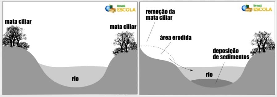
Imagem 1

(retirado de Brasil Escola)

Siltation is the process where water bodies are affected by the accumulation of sediments, resulting in excess material on his bed and hinders navigation and its use. Originally, this is a natural process, but that is intensified by human actions, especially since the removal of the riverbanks vegetation.

The process of sedimentation usually occurs as follows: with the rain, the soil is washed, or its surface layer is removed, and sediments (particles of soil and rock) are transported by flowing into the rivers, where they are deposited. When there are no obstacles to these sediments, function usually exercised by vegetation, a large amount is deposited at the bottom of the drainage networks.

This deposited material is carried by the river itself, and when it finds more local plans, where the velocity of the stream is not very accelerated, deposits in the background, accumulating and eventually forming sandbanks along the course d ' water. When the amount of sediment is very large and heavy, they carry up by rolling (at the bottom of rivers) or accumulate in normal bed, bringing damages to the river flow.

When man removes vegetation, mainly riparian vegetation (vegetation that lies on the banks of watercourses), the above process is intensified, and generate the emergence of erosion near the river itself, as illustrated the following images:
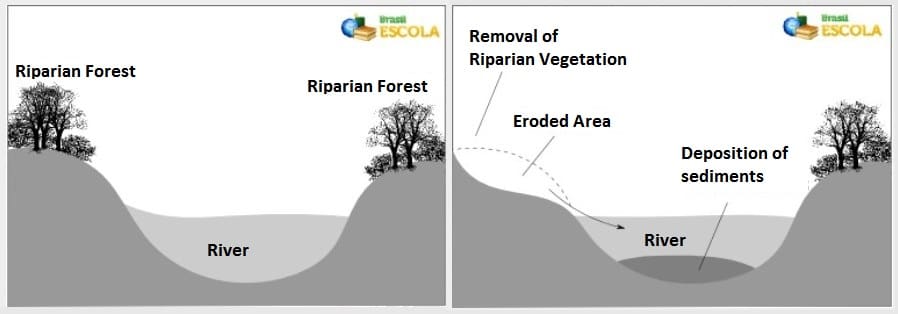
Imagem 1

(From Brasil Escola)

Para "Logar" esta EarthCache / To Log this EarthCache

Para “logar” esta cache deve visitar o local, nas coordenadas indicadas.

Depois deve responder às seguintes questões e enviar as respostas para o seguinte endereço jpp.geocaching@gmail.com

1. Explique o que se entende por assoreamento.

2. Nos últimos anos a zona do Bugio tem sofrido um assoreamento ou um desassoreamento?

3.De modo a evitar o fenómeno referido na pergunta 2, foi colocada uma estrutura na zona, indique qual.

4. Da posição em que se encontra, avalie aproximadamente, qual a profundidade do banco de areia.

5. (Opcional) Tire uma foto de com algo que o identifique como geocacher no local!

Em seguida poderá fazer o seu “found it” on-line!

To log this cache you must visit the coordinates above.

Then you must answer the following questions and send the answers to the following address jpp.geocaching@gmail.com

1. Explain what is a silting.

2. In recent years the area of Bugio has undergone sedimentation or silt?

3. In order to avoid this phenomenon in question 2, a structure has been placed in the zone, indicate what it is.

4. The position you are in, assess approximately how deep of the sandbar is.

5. (Optional) Take a picture with something geocache related in the coordinates!

Then you can claim your "found it" online!

This page was generated by Geocaching Portugal Listing Generator

Additional Hints (No hints available.)