QUIBERON: Tombolo ou Isthme ??? EarthCache
QUIBERON: Tombolo ou Isthme ???
-
Difficulty:
-

-
Terrain:
-

Size:  (other)
Please note Use of geocaching.com services is subject to the terms and conditions
in our disclaimer.
La pointe du Conguel.
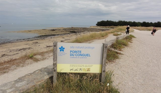 La pointe du Conguel est à l'origine une île reliée au continent par un tombolo long de 300 mètres.
TOMBOLO ou ISTHME: (c'est selon !!!)
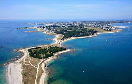
Située sur la presqu'ile de Quiberon, la pointe du Conguel est à l'origine une île, formée par des roches reliées entre elles par du sable accumulé.
Cette longue pointe d'environ 1 kilomètre de long sur 200 mètres de large est accessible par des sentiers de randonnée conduisant à une table d'orientation à son extrémité...
Les courants donnent une bonne explications du modelé dunaire et de l’implantation du tombolo. Ce sont eux qui portent vers la baie les débris de grands collecteurs comme la Vilaine ou la Loire. L’un des courants prend en écharpe la presqu’île à partir de la pointe du Conguel, glisse le long du littoral oriental, s’amortit peu à peu, alourdi par la masse d’alluvions puis freiné par la diminution des profondeurs ; il finit par allonger la flèche de Pen-er-Lé.
L’autre courant se forme aux alentours de Hoëdic, de Houat ou de la pointe du Conguel, puis se déplace vers l’arc sableux tendu entre la pointe de Beg-en-Aud et l’île de Rohellan..
Ce site comportant des lames de granite feuilleté à faible pendage ouest attirent l'attention des géologues.
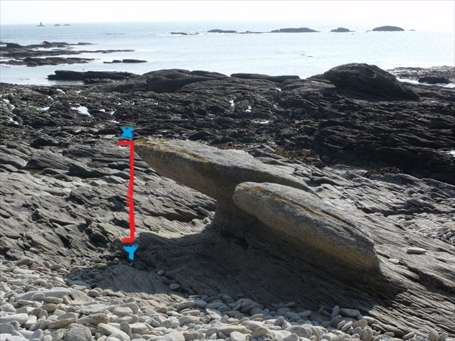 Au WP 2:Mesurer la hauteur (X-Y) de la plus grosse pierre à pendage en photo ci-dessus...
POUR VALIDER CETTE CACHE, REPONDEZ AUX QUESTIONS SUIVANTES:
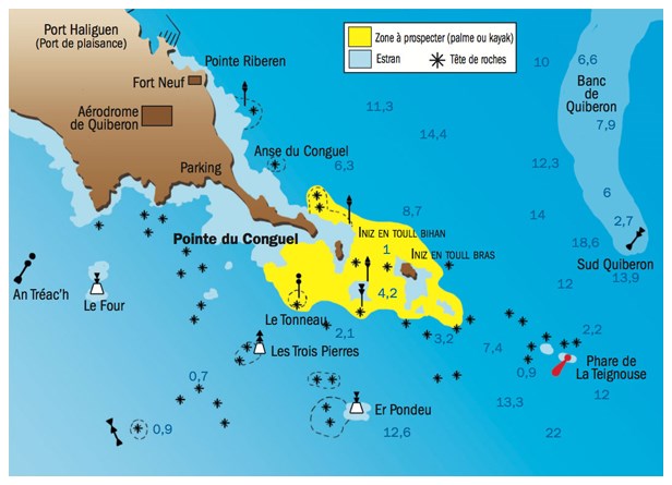
1) Noms des 2 ilots qui prolonge la pointe ?
Au WP 2:Mesurer la hauteur (X-Y) de la plus grosse pierre à pendage en photo ci-dessus...
POUR VALIDER CETTE CACHE, REPONDEZ AUX QUESTIONS SUIVANTES:
1) Noms des 2 ilots qui prolonge la pointe ?
2) Noms des 2 iles vues en face de la pointe ?
3) Au WP 1: Relever la date et l'heure du crash de l'avion sur la plaque ?
4) Au WP 2: Hauteur (X-Y)en mètre de la plus haute des pierres à pendage ?
5) Photo optionnelle du GPS devant la double pierre à pendage...
Loguez cette cache "Found it" et envoyez-moi vos propositions de réponses soit via mon profil, soit via la messagerie geocaching.com (Message Center), et je vous contacterai en cas de problème.
*************************************
Le terrain du site est protégé par le Conservatoire du littoral . Respectez les consignes, et ne vous aventurez pas sur cette pointe par mauvais temps...
 The tip of Conguel was originally an island connected to the mainland by a 300 meter long tombolo.
TOMBOLO or HISTHME: (this is according !!!)
Located on the Quiberon peninsula, the tip of Conguel was originally an island, formed by rocks connected by accumulated sand.
This long point about 1 kilometer long by 200 meters wide is accessible by hiking trails leading to a viewpoint at its end ...
The currents give a good explanation of the dune shaped and implementation of tombolo. It is they who bear the bay debris major collectors like the Vilaine and the Loire. One common scarf covers the peninsula from the tip of Conguel, slides along the eastern seaboard, is amortized gradually weighed down by the mass of alluvium and hampered by lower depths; he eventually extend the boom Pen-er-Lé.
The other stream is formed around Hoëdic, Houat or the tip of Conguel then moves sandy arc stretched between the tip of Beg-en-Aud and the island of Rohellan
This site featuring granite blades laminated low dipping west attract the attention of geologists.
In WP2: Measure (X-Y) the height of the largest stone dipping pictured above ...
TO VALIDATE THIS CACHE, ANSWER THE FOLLOWING QUESTIONS:
1) Names of two islands that extends the tip ?
2) Names of 2 islands views in front of the tip ?
3) At WP 1: Pick the date and time of the plane crash on the plate ?
4) In WP 2 meter (X-Y) height of the highest rocks dipping ?
5) Optional Photo GPS before the double dipping stone ...
Log in this cache "Found it" and send me your answers proposals or via my profile or via geocaching.com messaging (Message Center), and I will contact you in case of problems.
*****************************
The site of the land is protected by the Conservatoire du Littoral. Follow the instructions, and do not venture on this peak in bad weather ...
Indispensable*******Essential.. BELLE BALADE, JE VOUS ATTENDS/BEAUTIFUL WALKING, YOU WAIT
Additional Hints
(Decrypt)
Cbhe ovra qépbhieve yr fvgr; onynqr q'raiveba 3 xz ra obhpyr à yn erpurepur qrf vaqvprf .
******************
Gb qvfpbire gur fvgr; jnyx nobhg 3 xz ybbc va frnepu bs pyhrf.