HR
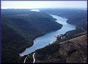
Limski kanal ubraja se u jedan od najljepših krajolika Istre. Dio je 35 km dugačke Limske udoline (drage) koja seže gotovo do Pazina u središtu Istre. Sam kanal je nešto duži od 10 km, a s obje njegove strane uzdižu se strme litice, ponegdje visoke i do 100 m. Pun je „zavoja“, a završava u Limskoj stražnjici (nije šala - njegovo dno naziva se Cul da Limo ili Limska guzica).
Kako je nastao? Prije nekoliko milijuna godina, za vrijeme miocena, ovdje je tekla prarijeka, preteča rijeke Pazinčice. Razina mora bila je znatno niža od sadašnje (oko 50 metara), a miocenske obilne kiše rijeku su radile snažnom tako da je voda i dalje ispirala vapnenac i dodatno produbila riječno korito. Dizanjem razine mora, more je doslovno potopilo prarijeku, a miocen sa svojim kišama je prestao, pa je i rijeka presušila, Pazinčica se premetnula u ponornicu, a ušće je postalo “kanal”.
Naziv mu vjerojatno potiče od riječi „limes“, što je latinska riječ za granicu, a Limski je kanal bio granica između puljskog i porečkoj agera (danas između Rovinja i Vrsara…)
Dno kanala skriva mnogobrojne komade antičkih predmeta, ali niti jedan nije nađen neoštećen. Tumačenje – vjerojatno su se u kanalu za vrijeme „nevera“ skrivali antički brodovi koji su u iščekivanju prestanka nevremena imali „generalno čišćenje“ pa su u more bacali sve što na brodu nije izdržalo plovidbu nemirnim morem.
Naziv Lim fjord nastao je nakon snimanja filma »Vikinzi« 1958. s Kirk Douglasom i Tony Curtisom, kada je Limski kanal odista »glumio« fjord pa se to nastojalo i komercijalno iskoristiti dok se nije urušilo vikinško naselje koje je bilo sagrađeno na Vrhu Lima.
U području Limskog kanala nalazi se Romualdova pećina - paleolitsko nalazište i zanimljiv speleološki objekt sa pećinskim ukrasima. Ulazak u spilju visok je 47 centimetara, glavna dvorana pet do šest metara, a dugačka je 105 metara. Romualdova pećina je speleološki fenomen, jer se spiljski ukrasi nalaze samo s lijeve strane dok je desna prazna. Temperatura je u njoj ugodnih 14º - 17º C i stalna je tijekom cijele godine. U njoj obitava velika kolonija šišmiša. Ulaz u špilju je zatvoren i posjet je moguć samo uz vodiča.
Gusarska spilja je jedna od nekoliko spilja uz Limski kanal. Može joj se pristupiti samo s mora. Naziv je dobila po gusarima koji su se u prošlosti često skrivali u ovoj spilji. Uz Limski kanal ima i okomitih stijena koje su cilj mnogih penjača.
More i podmorje, kao i krajolik Lima, danas je prirodni rezervat pod zaštitom. More u Limskom kanalu vrlo je čisto, što pogoduje uzgoju školjaka, mriještenju riba, i naravno - kupanju. U Limskom se kanalu uzgajaju ribe, a posebno je poznat po uzgoju dagnji i kamenica.
DE
Lim Fjord ist eine der schönsten Landschaften in Istrien. Er ist ein Teil der 35 km langen Lim Tal (Draga), die zurückreicht fast bis Pazin, im Zentrum von Istrien. Der Kanal ist etwas länger als 10 km, und auf beiden Seiten erheben sich steilen Klippen, manchmal bis zu 100 m hoch. Es ist voll von "Kurven" und endet in Lima Gesäß (es ist kein Witz, sein Meeresboden wird auch als Cul zur Limo oder Lim hintern genannt).
Vor ein paar Millionen Jahren, während des Miozäns, fließ ein großer Fluss, eine Vorstufe von Pazinčica. Der Meeresspiegel war deutlich niedriger (ca. 50 Meter), in Miozän als starke Regenfälle waren war der Fluss so stark, dass das Wasser den Kalkstein weggespült und das Flussbett sich weiter vertiefte. Als der Meeresspiegels anstieg, hat das Meer den Fluss buchstäblich ertrunken, das Miozän hat mit seinem Regenfällen aufgehört und die Flüsse sind ausgetrockne. Pazinčica wurde Grundwasser und taucht unter in Pazinska jama und die Mündung hat sich zu einem "Kanal" gemaht.
Sein Name kommt wahrscheinlich von dem Wort "limes", das lateinische Wort für Grenze ist, weil der Lim-Kanal ist eine Grenze zwischen Pula und Poreč (heute zwischen Rovinj und Vrsar ...)
Auf dem Meeresboden des Kanals verbergen sich zahlreiche Stücke von Antiquitäten, aber keines wurde in einem Teil gefunden. Weil wahrscheinlich im Kanal sich während der Stürme sich die alten Schiffe versteckten und wehrend sie warteten das sich der Sturm beruhigt hatten sie "Generalreinigung" und warfen alles vom Schiff was beim segeln kaputt gegangen ist auf hoher rauer See.
Der Name Lim Fjord wurde nach den Dreharbeiten zu "Die Wikinger" 1958 mit Kirk Douglas und Tony Curtis, erstellt, als der Lim-Kanal in der Tat "gehandelt" Fjord und es wurde versucht kommerziell zu nutzen, bis die Wikingersiedlung zusammenbrach, die auf der Oberseite des Lims gebaut wurde.
In dem Lim-Kanal ist die Romuald Höhle - interessanter Fundplatz und speläologischen Objekt mit Höhlenschmuck. Der Eingang der Höhle ist 47 Zentimeter hoch, im inneren ist sie fünf bis sechs Meter hoch und eine Länge von 105 Metern. Romualdo-Höhle ist eine Höhlen Phänomen, weil die Ornamente in der Höhle sich auf der linken Seite befindet, während die rechte leer ist. Die Temperatur in ihrem inneren ist komfortable 14º - 17º C und das ganze Jahr über konstant. Sie ist bewohnt von einer große Kolonie von Fledermäusen. Der Eingang zur Höhle ist geschlossen und der Besuch ist nur mit Führung möglich.
Piratenhöhle ist eine von mehreren Höhlen entlang des Lim-Kanal. Sie kann nur über den Seeweg erreicht werden. Sie erhielt den Namen nach den Piraten, die in der Vergangenheit oft in dieser Höhle sich versteckten. Der Lim-Kanal hat senkrechte Klippen, die das Ziel vieler Bergsteiger sind.
Meer und Unterwasser, sowie Landschaft Lims, ist heute ein Naturschutzgebiet der unter Schutz gestellt ist. Der Lim-Kanal ist sehr sauber, und das ist gut für den Anbau von Schalentiere, die Fische laichen hier, und natürlich – zum Schwimmen. In dem Lim-Kanal werden Fische gezüchtet, und er ist speziell für den Anbau von Muscheln und Austern bekannt.
EN
Lim channal is one of the most beautiful landscapes in Istria it is a part of 35 km long Lim Valley (Draga), which goes back almost to Pazin, in the center of Istria. The channel is slightly longer than 10 km, on both sides cliffs rise up, sometimes as high as 100 m. It's full of "bends" and ending in Lima „ass“ (no joke - its bottom is called Cul to Limo or Limska ass ).
A few million years ago, during the Miocene, there was flowing a river, a precursor Pazinčica. The sea level was considerably lower (about 50 meters) and Miocene heavy rains had worked the river so strong that the water washed away the limestone and further deepen the riverbed. Sea level has raised, the sea was literally drowning the river and the Miocene with its rains stopped and the rivers dried up, Pazinčica turned into the groundwater and the estuary has become a "channel".
Its name probably comes from the word "limes", which is Latin for the border, while the Lim Channel is a border between the Pula and Poreč (today between Rovinj and Vrsar ...)
The bottom of the channel hides numerous pieces of antique items, but none was found unharmed. Interpreting - probably in the channel during the "storm" were hiding ancient ships. While therewere waiting that termination storm they had "general cleaning" and throwing everything on the ship withstood sailing rough seas.
Name Lim fjord was created after the filming of "The Vikings" in 1958 with Kirk Douglas and Tony Curtis, when the Lim channel indeed "acted" fjord and it sought to commercially exploit until it collapsed Viking settlement that was built on top of Lima.
In the Lim channel is the Romuald's Cave - interesting Palaeolithic site and speleological object with cave decorations. Entering the cave is 47 centimeters high, the main hall is five to six meters high and a length of 105 meters. Romualdo's Cave is a speleological phenomenon because the cave ornaments are located on the left side while the right is empty. The temperature was in her comfortable 14º - 17º C and constant throughout the year. It inhabits a large colony of bats. The entrance to the cave was closed and the visit is possible only with a guide.
Pirate's cave is one of several caves along the Lim channel. It can be accessed only by sea. It was named after the pirates who have in the past often hid in this cave. With Lim channel has vertical cliffs that are the goal of many climbers.
Sea and underwater, as well as landscape Lima, today is a nature reserve under protection. Water in the Lim channel is very clean, which is good for the cultivation of shellfish, spawning fish, and of course - swimming. In the Lim channel is abreeding spot for fish, and is especially known for the cultivation of mussels and oysters.