POP CORN AT FENAIS
[Graciosa – Azores]
EARTHCACHE

PORTUGUÊS

A GEOLOGIA DA ILHA GRACIOSA
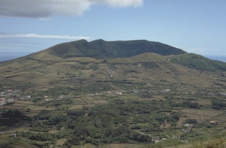
“A ilha Graciosa é um edifício vulcânico composto por cinco zonas: Complexo da Serra das Fontes; Complexo da Baía do Filipe; Complexo da Serra Branca; Complexo de Cobertura Basáltica (ex. Complexo Vulcânico da Vitória) e Vulcão Central. O edifício é predominantemente basáltico, com características que indiciam um vulcanismo predominantemente de baixa explosividade, embora apareçam alguns depósitos de natureza traquítico que indiciam fases de alguma explosividade.
A parte emersa da ilha terá sido iniciada há cerca de 1 050 000 anos ou mais de 700 000 anos com a formação de um vulcão em escudo, que ainda aflora no Complexo da Serra das Fontes, a parte mais antiga da ilha. A essa fase seguiram-se períodos de maior explosividade, associados às fraturas que percorrem a zona, que resultaram a formação de numerosos cones de escórias vulcânicas soldadas que constituem a maior parte das atuais Serra Dormida e Serra das Fontes.
O tipo de vulcanismo alterou-se radicalmente há cerca de 330 000 anos, com a formação de um vulcão de tipo central com caldeira, ligado a uma câmara com magma diferenciado, do qual resultaram erupções de grande explosividade que deram origem aos espessos mantos de traquito que constituem a Serra Branca.
Em período bem mais recente reativou-se o vulcanismo basáltico, resultando na formação de um novo edifício vulcânico caracterizado pela sua baixa explosividade, que formou a Complexo de Cobertura Basáltica (ex. Complexo Vulcânico da Vitória), com os seus numerosos cones, e os numerosos mantos basálticos subaéreos que recobrem o centro e o norte da ilha. Esta fase evoluiu para sueste da ilha, dando origem ao maciço da Caldeira (Vulcão Central) e às estruturas que lhe estão associadas, bem como a diversas erupções surtseianas na periferia da ilha, das quais resultaram os atuais ilhéus e diversas estruturas submarinas próximas à costa. A última erupção desta fase ocorreu há cerca de 3 900 anos, dando origem ao Pico Timão e às escoadas basálticas que lhe estão associadas”.

“Na ilha Graciosa não foi registado nenhum evento vulcânico histórico contudo, nos últimos 12.000 anos, registaram-se pelo menos 10 erupções vulcânicas, das quais se salienta um episódio havaiano intracaldeira (correspondente a um estratovulcão, vulcão central, vulcão poligenético com caldeira), que envolveu a produção de cerca de 100 x 106 m3de lava. A fase terminal deste evento foi expressa por um episódio de colapso no interior da caldeira, acompanhado pela drenagem de um lago de lava através da Furna do Enxofre. A erupção mais recente nesta ilha data presumivelmente de há menos de 2.000 anos e correspondeu à edificação do cone de escórias do Pico Timão. As escoadas lávicas aa geradas durante este evento excederam os 35 x 106 m3 e progrediram desde o topo da Serra Dormida até à costa, junto à Praia”.
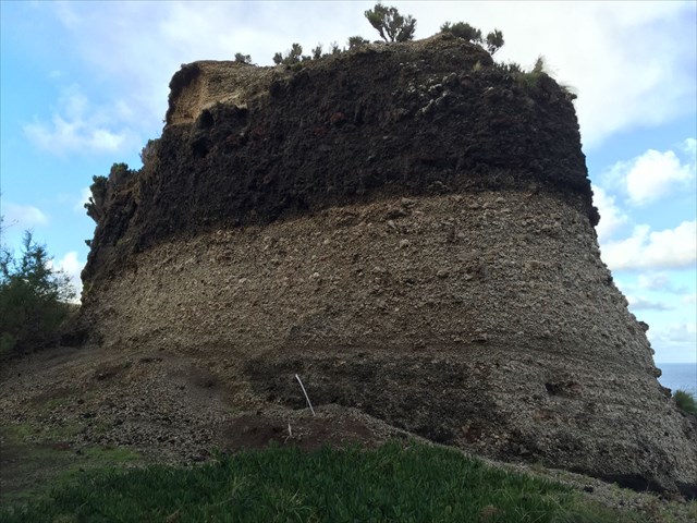
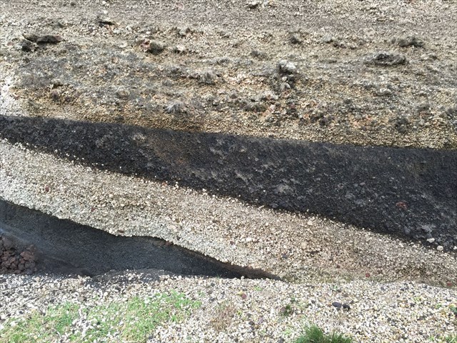
O PAREDÃO
Na zona do GZ existem, pelo menos, dois “paredões”, onde aparecem “faixas” de um conhecido “granulado”.
A origem e formação deste “paredão, pode ser descrita, do ponto de vista geológico, como:
“… é uma série associada à fase pliniana do Vulcão da Caldeira, em que as formações inferiores, chamam-se “rios de lama” (“mudeflow”). Entretanto a fase eruptiva… parou, e o vulcão entrou numa fase de emissão de pedra-pomes… Os “mudeflow” estão cobertos (capeados) por pedra-pomes de queda; isto é: pedra-pomes que se depositaram como chuva… Seguiu-se um período de repouso, que deu origem ao aparecimento do paleossolo visível no paredão (antes da parte negra). Mais tarde seguiram-se episódios basálticos (parte a negro no paredão). Na base deste paredão, podemos observar ***** e os mudeflow, que são “rios” ou escoadas de materiais piroclásticos, que desceram das vertentes, num ambiente fortemente aquoso…”.
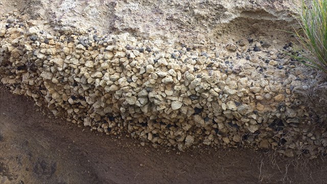
PEDRA-POMES
“Piroclasto de cor clara, associado a erupções explosivas de magmas diferenciados, siliciosos e intermédios. São fragmentos muito vesiculados, de grande porosidade e baixa densidade”.
PARA REALIZAR E REGISTAR ESTA EARTHCACHE:
PERGUNTAS:
Para “encontrar/registar” esta cache deverá: provar que esteve no local e responder às seguintes questões, enviando um email/mensagem de Geocaching, com as respostas, em português ou em inglês, para o nosso perfil.
Só depois, de enviar as respostas, e conforme as “guidelines” para as Earthcaches, deverá efetuar o seu registo!
Serão removidos todos os registos que não obedeçam a estes requisitos.
1. A partir do tema desta earthcache, responde às seguintes questões:
a) O edifício vulcânico da ilha Graciosa é constituído por quantas zonas distintas?
b) Caracteriza o vulcão que deu origem à zona do GZ desta earthcache.
2. Na zona do GZ, existem vários “paredões” com várias faixas e de diversas cores! Observando a zona do GZ responde às seguintes questões:
a) Existem faixas no paredão, compostas por “granulados! Como se chamam estes granulados?
b) Entre estes “granulados” existem umas “rochas pretas”!
Em termos vulcanológicos/geológicos, qual é o seu nome?
c) Qual o nome do fenómeno geológico, que se encontra na base do paredão?
d) Quantas faixas de cores distintas existem no paredão voltado a norte (portanto à direita quem desce o trilho)?
3. TAREFA OBRIGATÓRIA:Deverá tirar uma foto sua, onde você apareça (ou com um papel/placa onde conste o seu nickname e a data da visita) e que comprove a sua presença no GZ desta EC - NÃO META SPOILERS. Esta foto deverá ser colocada no seu registo ou enviada por email ou sistema de mensagens de Geocaching, para o owner!

Não responderemos ao seu contato, a não ser que haja algum “problema” com as suas respostas ou registo.


“POP CORN AT FENAIS”
[Graciosa - Azores]
ENGLISH

EARTHCACHE
THE GEOLOGY OF GRACIOSA ISLAND
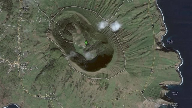
"The Graciosa is a volcanic structure consisting of five areas: Complexo da Serra das Fontes; Complex Philip Bay; Complexo da Serra Branca; Basalt Coverage complex (ex. Volcanic Complex of Victory) and Central Volcano. The building is largely basaltic, with features which point to volcanism predominantly low explosive, although they appear some deposits traquítico nature that indicate phases of any explosion.
The submerged part of the island have been started about 1.05 million years or over 700,000 years with the formation of a shield volcano, which still flourishes in the Complexo da Serra das Fontes, the oldest part of the island. At this phase was followed by periods of greater explosion, associated with fractures that run through the area, which resulted in the formation of numerous welded volcanic cinder cones that make up most of the current Serra Bed and Serra das Fontes.
The type of volcanism changed radically for about 330,000 years, with the formation of a central type volcano with boiler connected to a camera with differentiated magma, which resulted in large explosive eruptions that gave rise to thick mantles of trachyte which make up the Serra Branca.
In much more recent period reactivated up the basaltic volcanism, resulting in the formation of a new volcanic building characterized by its low explosion that formed the Basalt Coverage Complex (ex. Volcanic Complex of Victory), with its numerous cones, and numerous subaerial basaltic robes that cover the center and north of the island. This phase evolved into the island's southeast, giving rise to massive Boiler (Central Volcano) and the structures associated with him, as well as several surtseianas eruptions on the outskirts of the island, which resulted in today's islanders and several nearby subsea structures to the coast . The last eruption of this phase occurred about 3900 years, giving rise to the Timão Peak and basaltic disposed attached to it. "
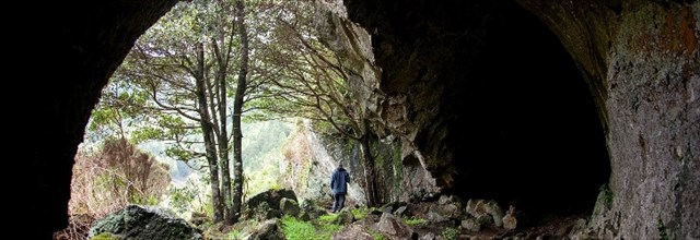
"In Graciosa no historical volcanic event has not been registered yet in the last 12,000 years, there have been at least 10 volcanoes, of which highlights a intracaldeira Hawaiian episode (corresponding to a stratovolcano, central volcano, polygenetic volcano caldera) involving the production of about 100 x 106 m3 of washing. The terminal phase of this event was expressed by an episode of collapse in the boiler, accompanied by drainage of a lake of lava through the Sulfur Cavern. The most recent eruption on the island date presumably from less than 2,000 years and corresponded to building the cone of slag from Pico Timão. The aa lava flows generated during this event exceeded the 35 x 106 m3 and progressed from the top of Serra Overnight to the coast, near the beach. "

THE WALL
GZ in the area there is some "walls", where they appear "tracks" of a known "grainy".
The origin and formation of this "wall, can be described, from the geological point of view, such as:
"... It is a number associated with Plinian phase of the fire volcano, wherein the lower formations are called" muddy rivers "(" mudeflow "). However the eruptive phase ... stopped, and the volcano has entered a phase of emission pumice ... The "mudeflow" are covered (capped) by falling pumice; ie pumice that were deposited as rain ... This was followed by a rest period, which led to the appearance of visible palaeosol the wall (before the black part). Later followed by basaltic episodes (the black part in the wall). At the base of this wall, we can see ***** and mudeflow, which are "rivers" or disposed of pyroclastic materials that came down from the slopes, in a strongly aqueous environment ... ".
Pumice
"Light-colored tephra associated with explosive eruptions of differentiated, silicon and intermediate magmas. Are very vesiculados fragments, high porosity and low density. "

TO PERFORM AND LOG THIS EarthCache:
QUESTIONS:
To "find / register" this cache must: prove that visited the site and answer the following questions by sending an email / message Geocaching, with answers (in Portuguese or in English, only) to our profile.
Only later, sending the answers, and as the "guidelines" for EarthCaches should make your registration! They will be removed from all records that do not meet these requirements.
1. From the theme of this EarthCache, answer the following questions:
a) The volcanic edifice of Graciosa consists of many different areas?
b) It features the volcano that gave rise to the GZ zone this EarthCache.
2. In the area of GZ, there are several "walls" with various groups and of
different colors! Observing the area of GZ answers the following questions:
a) There are tracks on the wall, composed of "pellets! What do you call these pellets?
b) Among these "pellets" are a "black rocks"! In vulcanological /
geological terms, what is your name?
c) What is the name of the geological phenomenon, which is in the wall
of the base?
d) How many distinct color bands exist in the wall facing north
(therefore the right who comes down the track)?
3.
TASK (not optional): You must take a picture of yourself, where do you show up, (or with a paper / plaque with your geocaching nickname and the date of the visit) and that proves your presence in the GZ of this EC - no spoilers please. This photo must be placed in your log or sent by email or Geocaching messaging system, to the owner!

We do not respond to your touch, unless there is a "problem" with their answers or register.


