To log this earthcache, send me the answers to the following questions to my geocaching account.
1. Why are the chain of rocks still here?
2. What type of bedrock is at this location?
3. Depending on water levels, are you able to see the chain of rocks during your visit? If not, how much of the rocks do you see in the dam south of the bridge?
4. Post a picture of yourself (face not required) or a personal item at the Chain of Rocks Bridge or dam below.
During the last ice age, the Mississippi River was re-routed from its original channel in soft river sediment (farther to the east in present day Illinois) to its present channel over resistant (mainly limestone) bedrock. The river has yet to wear down the bedrock and this feature is still a rough spot in the river. If the bridge had been built straight, the engineers would have had to choose between two problematic routes. One route would have put the bridge in a location where it couldn’t have been solidly founded on bedrock. The other route would have posed problems to river navigation by not allowing barges to line up with the current, possibly causing them to collide with the bridge. Although this bend was troublesome for motor traffic, it served as a compromise between geological and navigational concerns.
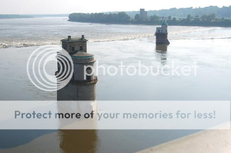
The Grand Chain, a series of rock ledges that impeded navigation, begins at the little castles in the river and stretches for three miles upstream. Illinoian ice blocked the channel of the Mississippi where it flowed to the east of the Grand Chain and forced the river to cut a new channel over erosion-resistant rock. Fingers of limestone reach out from the Missouri shore, creating the Grand Chain, a stone ledge that made navigation difficult at all river stages and impossible at low water. At this point glacial ice never touched the Missouri side of the river, though south of here the river flowed through the City of St. Louis and straight down Kingshighway. When the ice retreated the river continued to flow over the ledge of rock, but not along Kingshighway.
The bridge's name comes from a large shoal, or rocky rapids, called the Chain of Rocks, which made that stretch of the Mississippi extremely dangerous to navigate. Because of a low-water dam built by the Corps of Engineers in the 1960s, little of the Chain of Rocks is visible today except during extreme low water conditions. After 1940, only a single impediment prevented the maintenance of a safe and reliable 9-foot navigation channel on the Mississippi River from St. Paul, Minnesota, to New Orleans. This impediment, known as the Chain of Rocks Reach, was a 17-mile series of rock ledges that began just north of St. Louis and was extremely difficult and dangerous to navigate. In the late 1940s and early 1950s the U.S. Army Corps of Engineers built a 8.4-mile-long canal to bypass this treacherous reach. The canal and locks allow river traffic to bypass a portion of the river that is unnavigable in low water due to an anticlinal exposure of bedrock in the river—a "chain of rocks". The chain of rocks stretch for seven miles immediately to the north of the city of St. Louis. The Mississippi's water, narrowed by these rock ledges, rushes through this reach at speeds of 12 feet per second, roaring down a decline of 11 feet in seven river miles.
The chain of rocks that you see just south of the bridge is not a rapids; it’s a low water dam. The Grand Chain as an Army Engineer termed it in 1871, is a ledge of limestone that stretches upriver for three miles from the little castles that sit in the river just below the bridge and above the dam. he engineers dumped tons of rock to form the Chain of Rocks Low Water Dam. Work started in 1959 and was completed five years later. The dam is essentially a rock dike that stretches 3,240 feet from bank to bank, with a kink in the middle. Its average height is 8 feet LWRP, that is the elevation of the surface of the river at a low flow of 54,000 cubic feet per second. The crown of the dam is 30 feet wide. From the Illinois shore we see it as a rapids just below the Chain of Rocks bridge. To ensure adequate depths in the pool below the old Lock and Dam 26, a non-movable, low water dam was constructed just downstream of the old bridge and a lock was installed at the south end of the canal. Known respectively as Dam No. 27, also called Chain of Rocks Dam, and Locks No. 27, or Chain of Rocks Lock. This dam is the first permanent rock-fill dam across a major river in the United States.
So why the bend in the bridge?
They started construction on the Missouri side before they had found the bedrock anchor for the pier on the Illinois bank. They never did, at least not in the place they needed it for a straight bridge. So, the Scott’s engineers poked around along the Illinois shore until they found bedrock 200 yards up stream, and built a 22 degree left/right turn into the bridge.
The bridge’s most striking feature is its 22-degree turn in the middle. This bend is a compromise due to the unique geology of the area and concerns about the navigation of river traffic around the bridge pylons. Another interesting feature is the Chain of Rocks, a rocky area in the Mississippi that gave the bridge its name. During low water, it looks as though there is a small waterfall in the Mississippi. This feature used to wreak havoc with river navigation and has since been bypassed by the man-made Chain of Rocks Canal.
Both the strange 22-degree turn in the bridge and the Chain of Rocks owe their existence to glaciers. During the last ice age, the Mississippi River was re-routed from its original channel in soft river sediment to its present channel over resistant, mainly limestone, bedrock. The river has yet to wear down the bedrock and this feature is still a rough spot in the river. If the bridge had been built straight, the engineers would have had to choose between two problematic routes. One route would have put the bridge in a location where it couldn't have been solidly founded on bedrock. The other route would have posed problems to river navigation by not allowing barges to line up with the current, possibly causing them to collide with the bridge. It served as a compromise between geological and navigational concerns.
The Chain of Rocks Canal is a 8.4 mile long man made channel built through Illinois to bypass the Chain of Rocks in the late 1950’s and early 1960’s. A below water dam was built across the Mississippi River below the Chain of Rocks to keep the river level high enough at the upstream end of the canal to provide adequate flows/levels for navigation within the canal. Due to bedrock being so close to the surface, the canal could only be so deep. Since cutting through the rock would be dramatically more expensive, an alternate solution of providing a deeper channel was accomplished by building a dam across the Mississippi River just south of the entrance to the canal. This caused water to back up behind the dam, raising the level of the river by 3 feet, giving the canal an extra 3 feet of water depth. The dam across the Mississippi River did not need to provide for navigation. So rather than building an elaborate lock and dam structure, the US Army Corps Of Engineers simply dumped barge load after barge load of rock in the river. The water raises up behind the rocks, and then flows over the rocks.
Two gothic castle-like structures stand in the river just to the south of the bridge. These structures serve as water intakes for the Chain of Rocks Water Treatment Facility, which opened in 1894 and is still in operation. Excellent views of the St. Louis skyline and the Mississippi River are visible from the bridge. Bald eagles may also be present during colder weather. Bring the camera and binoculars when visiting this attraction.
If a bridge were built in a similar location today, the extra expense to make the bridge straight would certainly be spent. In the day of the Old Chain of Rocks Bridge, cars were narrower, slower, and traffic was less of a concern. Today’s foundation piers can also be driven more efficiently and to deeper depths. The old bridge is still structurally sound after all its years. The unusual the bend in the fifteen-span bridge definitely adds character and doesn’t give pedestrians or cyclists any grief.
When the Chain of Rocks Canal opened, it carried all large navigational traffic around the Chain of Rocks and other rough spots in the river. When the 1967 bridge carrying I-270, known as the New Chain of Rocks Bridge, was built, navigation below was of little concern. This enabled costs to be cut by constructing a bridge on a simple girder supported by 19 piers. This design is cheaper to construct and maintain because a superstructure is absent. This bridge is just north of the Old Chain of Rocks Bridge.