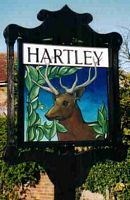
Hartley is a village and civil parish in the Sevenoaks district of Kent, England. It is located around 4.5 miles (7 km) southwest of Gravesend and just south of Longfield in the neighbouring borough of Dartford.
The village of Hartley is recorded as Erelei in the Domesday Book of 1086, with a population of 15 families and 3 slaves.[2] The name Hartley means "place in the wood where the deer are". The parish church of All Saints dates from the early 12th century, although it probably replaced an earlier Anglo-Saxon building.
On 28 January 1554, during Wyatt's Rebellion against Queen Mary, a rebel force of about 500 men led by Henry Isley clashed with a similar-sized loyal force led by Lord Abergavenny and Sir Robert Southwell, at Wrotham Hill. After a running battle over about four miles, the rebels made their last stand at Hartley Wood, where they were defeated.
By 1872, there were 47 houses in Hartley with a population of 244. Some local farms specialised in hop growing. A National School was built in the village in 1841; it was rebuilt in 1960 on a new site.
The opening nearby of Longfield railway station in 1872 began the evolution of the village from an agricultural to a commuter community. Just before World War I, two agricultural estates were purchased by a property developer and sold off in small plots for new houses and bungalows. Major housing developments at New Ash Green in the 1960s and Wellfield in the 1970s continued the trend.
The parish was part of Axstane Hundred and later Dartford Rural District.

The above coordinates will take you to the Hartley village sign, to find the cache please solve the following:
Nearby the sign there is a wooden bench dedicated to a local couple with two years given, ABCD - EFGH
N51 23. (D-H) (A*B) (G-E)
E000 18. (F/B) (H+A) (H*A)
The cache contains a log book only, please bring a pen.
If anybody would like to expand this series please do. I would just ask that you let Smokeypugs know first so they can keep track of the Village Sign numbers and names to avoid duplication.