FAJÃ DA PRAIA DO NORTE
[Faial – Azores]
EARTHCACHE
PORTUGUÊS
FAJÃ DA PRAIA DO NORTE
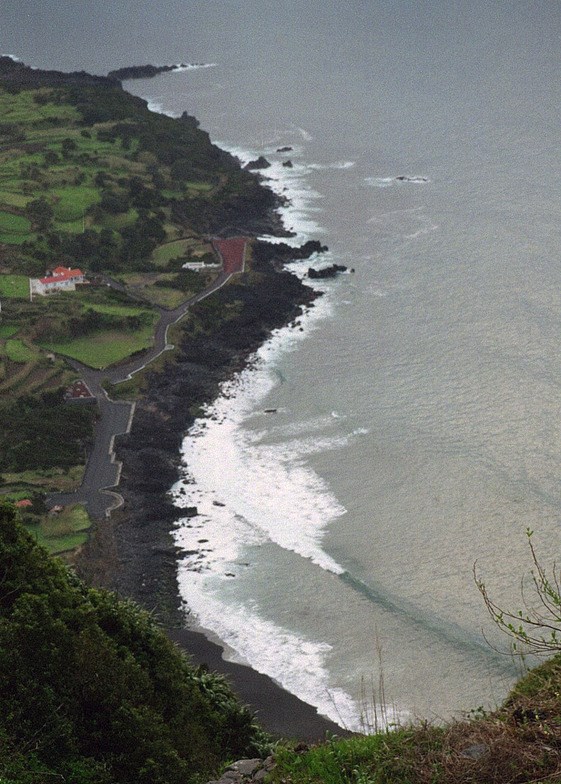
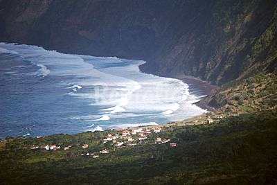
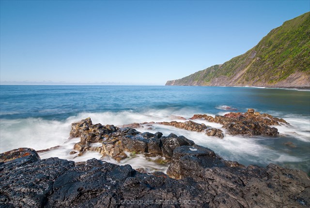
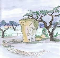
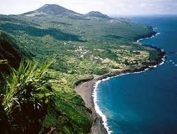
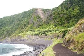
A Fajã da Praia do Norte localiza-se na costa Norte da ilha do Faial, na freguesia da Praia do Norte e ilustra o eterno duelo entre o mar e os vulcões. Sobranceira a uma imponente arriba coberta por vegetação da floresta Laurissilva, o seu prolongamento surge como resultado de uma escoada lávica da erupção histórica do Cabeço do Fogo (1672/73). A formação geológica recente e a existência de um microclima possibilitaram o assentamento humano, tornando a Fajã da Praia do Norte conhecida pelo seu vinho, adegas e casas de veraneio. Uma pequena praia, a Praia do Norte, que deu nome à localidade, ostenta magníficas areias escuras, que um olhar mais atento revela serem de cor verde. Esta praia é procurada por praticantes de surf, dadas as boas condições de mar para este tipo de prática. Na área encontramos também um pequeno porto, talhado numa magnífica escoada lávica que encerra um dos mais belos tesouros geológicos da região, os xenólitos olivínicos. Atualmente com cerca de 30 habitantes, das memórias de tempos antigos resta apenas a pequena Ermida de Nossa Senhora da Penha de França, edificada em 1787 e as rochas… Rochas que testemunham a criação telúrica das ilhas evidenciando a estreita relação entre açorianos e a terra que os viu nascer.
AS FAJÃS
Fajãé um termo de origem obscura que designa umterrenoplano, em geral cultivável, de pequena extensão, situado à beira-mar, formado de materiais desprendidos das arribas ou por deltas lávicos resultantes da penetração nomarde escoadas delava provenientes da vertente.Pode-se definirfajãcomotoda a terra baixa e chãou comopequena extensão de terreno plano, suscetível de cultura, junto a uma rocha, geralmente à beira-mar, formada em regra por materiais desprendidos por quebradas ou acumulados na foz de uma ribeira e assentes quase sempre num banco de lava muito resistente.
A palavrafajãestá expandida em toda aMacaronésialusófona, sendo muito comum nos Açores, onde aparece em quase todas as ilhas, nailha da Madeirae em muitas ilhas deCabo Verde.
Embora o termofajãseja em geral utilizado para designar plataformas costeiras, é por vezes utilizado na toponímia da Macaronésiaem ligação a pequenas zonas planas anichadas junto a montes ou colinas com encostas íngremes. É o caso das zonas aplanadas onde se situam as freguesias deFajã de Baixoe deFajã de Cima, nailha de São Miguel, ambas freguesias interiores sem qualquer ligação à costa. O mesmo acontece com o topónimo Fajã das Ovelhas, um local de altitude, nas faldas norte daSerra de Santa Bárbara, na ilhaTerceira. Nesta aceção a palavra confunde-se com o termoachada, também utilizado naMacaronésiapara descrever uma zona aplanada entre montes, em especial as plataformas planálticas suspensas entres os grandes vulcões centrais das ilhas e a costa.
Apesar de existirem fajãs em quase todas as ilhas da Macaronésia, elas são mais comuns, ditando em boa parte a distribuição da população, nailha de São Jorge. Naquela ilha, as vilas sedes dos seus dois concelhos,VelaseCalheta, situam-se em fajãs, o mesmo acontecendo à vila dasLajes do Pico, na vizinhailha do Pico.
Tipos de fajãs
De acordo com as suas características, origem e localização, as fajãs podem ser classificadas em:
1) Fajãs costeiras– fajãs em contacto direto com o litoral.
Fajãs de delta lávico– fajãs criadas quando as escoadas delavaavançam sobre o mar, provocando o recuo da linha de costa. Estas fajãs, em geral muito resistentes à erosão do mar por serem constituídas por grandes massas rochosas compactas e sem fissuração apreciável, são em geral delimitadas por costas abruptas, angulosas, fortemente recortadas, com grandes calhaus no seu sopé. Os solos, quando não tenha havido recobrimento por materiais de projeção ou derrocadas posteriores, são em geral esqueléticos. À superfície destes deltas podem ocorrer pseudo-crateras ou cones litorais e a erosão da frente da escoada ou uma drenagem posterior conferem-lhe frequentemente um aspeto digitado. São frequentes os arcos rochosos costeiros e as grutas marinhas resultantes da infraescavação pela erosão por ação do mar.
Fajãs de talude (ou fajãs detríticas)– são fajãs criadas pela acumulação de materiais resultantes do desmoronamento das encostas sobranceiras. Estas fajãs tendem a ser mais aplanadas e, por serem constituídas por materiais soltos, facilmente sujeitos ao transporte pelasondas, têm em geral costas de formas suaves e quase retilíneas, com praias de calhau rolado de dimensão variável. Nas costas mais expostas à ondulação, em geral as viradas a norte, formam-se por vezescordões de calhaus roladosque conduzem ao aparecimento de formações lagunares (como acontece naFajã da Caldeira de Santo Cristo). Os solos destas fajãs são em geral muito férteis, embora as mais perigosas, para habitação humana, dada a recorrência dos desmoronamentos. Os grandes terramotos tendem a formar novas fajãs deste tipo, como aconteceu profusamente no grande sismo doMandado de Deus, na metade leste de São Jorge.
2) Fajãs de altitude e pequenasachadas– fajãs encaixadas em encostas longe do mar, em geral pequenos planaltos ou vales aplainados no sopé de montanhas ou de cones vulcânicos.
Fajãs de encosta– plataformas formadas em consequência de quebradas que deixam plataformas de ablação nas encostas. Em geral de pequena extensão, apresentam pouco interesse para uso humano, mas são importantes como biótopospara espécies que exigem boa exposição solar e boa drenagem.
Fajãs de sopé ou pequenasachadas– são plataformas aplanadas existentes no sopé de encostas ou entre cones vulcânicos. O termoachadaresulta do seu interesse como locais privilegiados de cultivo, preferidos para fixação pelos colonizadores quando osachavamno desbravar das ilhas.
PARA REALIZAR E REGISTAR ESTA EARTHCACHE:
PERGUNTAS:
Para “encontrar/registar” esta cache deverá: provar que esteve no local e responder às seguintes questões, enviando um email/mensagem de Geocaching, com as respostas, em português ou em inglês, para o nosso perfil.
Só depois, de enviar as respostas, e conforme as “guidelines” para as Earthcaches, deverá efetuar o seu registo!
Serão removidos todos os registos que não obedeçam a estes requisitos.
1. Responde às seguintes questões:
a) Explica, por palavras tuas, o que é uma fajã.
b) Classifica a Fajã da Praia do Norte.
c) Apresenta dois exemplos de fajãs lávicas, existentes nos Açores.
d) Indica dois exemplos de fajãs detríticas existentes nos Açores.
e) Estima a altura da falésia que se situa junto à Fajã da Praia do Norte.
2. Observando a zona do WP1 (ponto de observação), verás que o solo, nesta zona, é composto por um determinado tipo de matéria vermelha.
a) Qual o nome deste material vermelho?
b) Sempre foi vermelho? Por que razão mudou de cor e ficou vermelho?
c) Perto do fontenário existe uma mesa de pedra. Qual o tipo de pedra?
3. Observo a zona do GZ, junto ao mar.
a) Classifica o tipo de “material” observado, nomeadamente indicando o seu tipo, cor e granulometria.
b) Observando a areia desta praia, poderás notar que é, por vezes, e em vários locais esverdeada! A que se deve esta cor?
4.
TAREFA OBRIGATÓRIA:Deverá tirar uma foto sua, onde você apareça (ou com um papel/placa onde conste o seu nickname e a data da visita) e que comprove a sua presença no GZ desta EC - NÃO META SPOILERS. Esta foto deverá ser colocada no seu registo ou enviada por email ou sistema de mensagens de Geocaching, para o owner!
Não responderemos ao seu contato, a não ser que haja algum “problema” com as suas respostas ou registo.


FAJÃ DA PRAIA DO NORTE
[Faial - Azores]
ENGLISH

EARTHCACHE
“FAJÃ DA PRAIA DO NORTE”
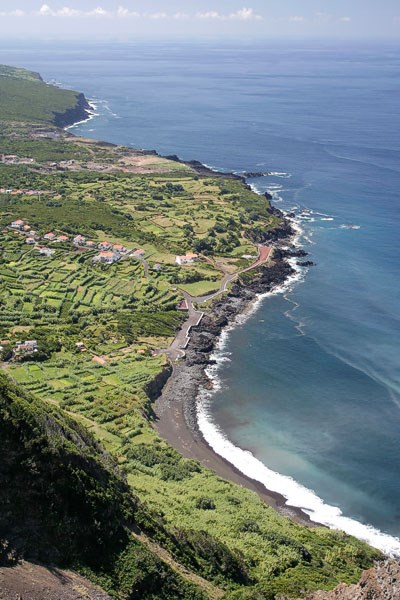
North Beach Faja of A is located on the north coast of Faial, in the village of North Beach and illustrates the eternal duel between the sea and the volcanoes. Overlooking a towering cliff covered by vegetation of the laurel forest, its extension is the result of a lava drained the historic eruption of the Cabeço do Fogo (1672/73). The recent geological formation and the existence of a microclimate allowed human settlement, making the North Praia da Faja known for its wine, wineries and vacation homes. A small beach, Praia do Norte, which gave its name to the town, boasts magnificent dark sand, a closer look reveals be green. This beach is visited by surfers, given the good sea conditions for this type of practice. In the area we also find a small harbor, a magnificent carved lava drained terminating one of the most beautiful geological treasures of the region, olivínicos xenoliths. Currently about 30 inhabitants of ancient times memories there remains only the Chapel of Our Lady of Penha de France, built in 1787 and the rocks ... Rocks witness the telluric creation of the islands showing the close relationship between the Azores and the land We were born.
THE: “FAJÃS”
“Fajã” is an obscure source term for flat terrain generally arable, of small extent, situated by the sea, formed of material detached from cliffs or lava deltas resulting from the penetration in the sea of lava from the slope disposed. You can set fajã as all the low land and tea or as small tract of land plan, susceptible of culture, next to a rock, usually by the sea, formed usually by loosened materials for broken or accumulated at the mouth of a river and based almost always a very tough lava bank.
The word fajã is expanded throughout the Lusophone Macaronesia and very common in the Azores, where it appears in almost all the islands, the island of Madeira and in many islands of Cape Verde.
Although the term “fajã” is generally used to designate coastal platforms, is sometimes used in place names in the Macaronesia in connection to small anichadas flat areas along the mountains or hills with steep slopes. This applies to the flattened areas where are the parishes of Faja de Baixo and Faja de Cima on the island of São Miguel, both inland parishes without any connection to the coast. The same applies to the place-name Faja the Sheep, a place of altitude, in the northern foothills of the Sierra de Santa Barbara, Terceira. In this meaning the word is confused with the term found, also used in Macaronesia to describe a flattened area between hills, especially plateau suspended platforms entres major central volcanoes of the islands and the coast.
Although there “fajãs” in almost all the Macaronesian islands, they are more common, largely dictating the distribution of population on the island of São Jorge. On that island, villages headquarters of its two counties, candles and Calheta, are located in coves, as has the village of Lajes do Pico, on the neighboring island of Pico.
Types of “Fajãs”
According to its characteristics, origin and location, the coves can be classified into:
1) Coastal Fajãs- fajãs in direct contact with the coast.
Fajãs of lava delta- fajãs created when lava drained advance of the sea, causing the retreat of the shoreline. These coves in very resistant to erosion by the sea usually are made from large rock masses and compact without appreciable cracking, are generally bounded by abrupt back, angular, heavily cut, with large pebbles in his foot. The soils, when there was no covering for projection of material or subsequent landslides, are generally skeletal. On the surface these deltas may occur pseudo-craters or coastal cones and the front of the erosion of drained or a later drainage often give it a typed aspect. Are frequent coastal rocky arches and sea caves resulting from infraescavação erosion by action of the sea.
Slope Fajãs (or fajãs detrital)- fajãs are created by the accumulation of materials resulting from the collapse of hillsides. These fajãs tend to be flattened, and are constituted by loose material easily subject to transportation waves, have generally smooth back and almost rectilinear shapes with rolled pebble beach variable dimension. In the most exposed back to the waves, in general face north, formed sometimes pebbles rolled seams that are resulting in lagoon formations (as in the Faja Caldeira de Santo Cristo). The soils of these coves are very fertile general, although the most dangerous for human habitation, given the recurrence of landslides. The great earthquakes tend to form new coves such as profusely happened in the great earthquake of Warrant of God, in the eastern half of St. George.

2) Fajãs altitude and small found- fajãs fitted on slopes away from the sea, usually small plateaus or flattened valleys at the foot of mountains or volcanic cones.
Slope of coves- platforms formed as a result of broken leaving ablation platforms on the slopes. Generally of small extent, have little interest for human use, but are important as biotopes for species that require good sun exposure and good drainage.
Foot of coves and small found- are flattened existing platforms in the slopes of the foot or between volcanic cones. The term results found of interest as privileged places of culture, preferred for fixing by settlers when they thought the blaze in the islands.

TO PERFORM AND LOG THIS EarthCache:
QUESTIONS:
To "find / register" this cache must: prove that visited the site and answer the following questions by sending an email / message Geocaching, with answers (in Portuguese or in English, only) to our profile.
Only later, sending the answers, and as the "guidelines" for EarthCaches should make your registration! They will be removed from all records that do not meet these requirements.
1. Answer the following questions:
a) Explain, in your words, what a fajã.
b) Sorts the Faja of North Beach.
c) provide two examples of lava coves, existing in the Azores.
d) indicate two examples of detrital coves existing in the Azores.
e) estimated the height of the cliff that is located next to the Faja
of North Beach.
2. Observing the area of the WP1 (observation point), you see that the ground in this area consists of a particular type of red matter.
a) What is the name of this red stuff?
b) It was always red? Why he changed color and became red?
c) Near the Fontenario there is a stone table. What kind of stone?
3. observe the area of GZ, by the sea.
a) classifies the type of "stuff" observed and specify its type, color
and particle size.
b) observing this beach sand, you may note that it is sometimes and
green various locations! Why is this color?
4.
TASK (not optional): You must take a picture of yourself, where do you show up, (or with a paper / plaque with your geocaching nickname and the date of the visit) and that proves your presence in the GZ of this EC - no spoilers please. This photo must be placed in your log or sent by email or Geocaching messaging system, to the owner!

We do not respond to your touch, unless there is a "problem" with their answers or register.

