O GRABEN

DE PEDRO MIGUEL
[Faial – Azores]
EARTHCACHE

PORTUGUÊS

PEDRO MIGUEL
Pedro Miguel é uma freguesia portuguesa do concelho da Horta, na Ilha do Faial, Região Autónoma dos Açores. Ocupa uma superfície total de 14,71 km² com 759 habitantes (2011). Possuí uma densidade populacional de 51,6 hab/km². A freguesia conta com cerca de 500 eleitores inscritos. A Sede de Freguesia dista da cidade da Horta 6 km para Norte.
GRABEN DE PEDRO MIGUEL
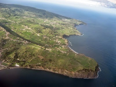
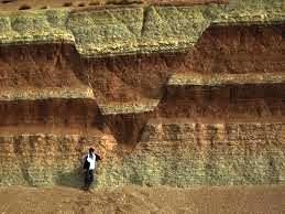
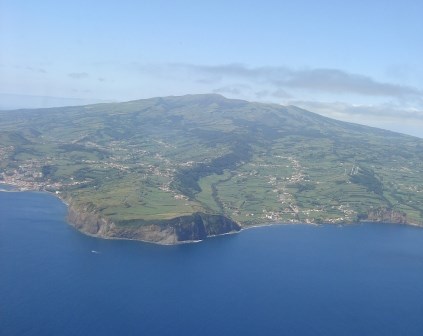
“ Graben de Pedro Miguel localiza-se na zona Leste do Faial e constitui uma das principais estruturas tectónicas e morfológicas da ilha.
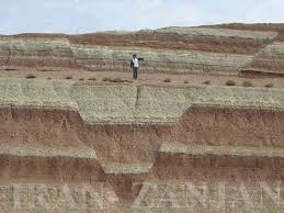
Caracteriza-se por um relevo em escadaria, dominado pelo sistema de falhas distensivas de orientação geral WNW-ESE, evidenciado por escarpas de falha com altura máxima da ordem de 170 m e que na zona do vulcão da Caldeira estão cobertas/dissimuladas por depósitos de pedra-pomes e de outros tefras holocénicos.
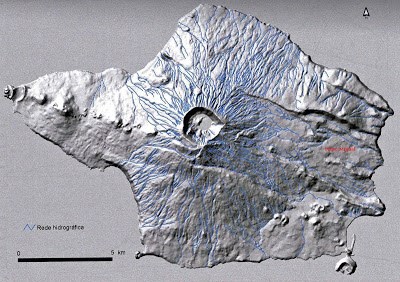
O graben é formado por cinco patamares abatidos entre falhas normais, designadamente das falhas da Ribeirinha, da Lomba Grande, da Ribeira do Rato, da Rocha Vermelha, da Espalamaca e de Flamengos, situando-se a freguesia de Pedro Miguel no patamar central e mais baixo do graben.
Desenvolvendo-se nos últimos 73.000 (ou 40.000) anos, a génese inicial do graben de Pedro Miguel estará associada ao vulcão em escudo da Ribeirinha, quer devido a movimentações magmáticas profundas associadas aos reservatórios magmáticos, quer a fenómenos tectónicos distensivos que afetaram a ilha do Faial”.
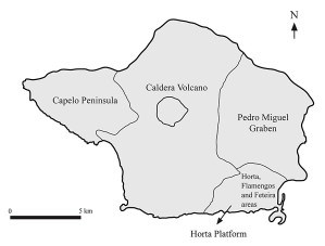
Geoparque Açores
O Graben de Pedro Miguel constitui a principal estrutura vulcano-tectónica da ilha e a mais impressionante dos Açores. Apresenta um sistema de falhas distensivas de orientação ONO-ESE, que confere uma topografia em degraus ao antigo vulcão em escudo da parte oriental da ilha do Faial.
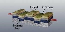
As falhas normais estão associadas a movimentos de distensão, ou seja, a locais onde a superfície da Terra está estender-se ou, como alguns dizem, a ser “esticada”.
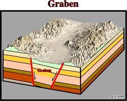
Quando falhas normais, aproximadamente paralelas, inclinam em sentidos opostos para o espaço entre elas formado, cria-se uma espécie de vale, de fundo mais ou menos largo, e gera-se um bloco abatido entre as falhas. A esta estrutura chama-se em geologia Graben, uma palavra de origem alemã que significa fosso ou trincheira.
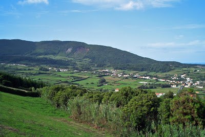
Todos os post com a designação de "O Faial cortado à faca" e com a etiqueta "graben" mostram partes de uma das mais importantes estruturas geomorfológicas ou tectónicas do Faial, muito evidente na metade oriental da ilha, cujo eixo central se situa na freguesia de Pedro Miguel e designada por: Graben de Pedro Miguel.
No Gabren de Pedro Miguel, evidenciam-se duas falhas: a falha da Ribeira do Rato (mais à direita) e a escarpa da falha da Lomba Grande, que inclinam ambas para sul.
Quando se faz uma modelação do relevo do Faial, o Graben de Pedro Miguel destaca-se imediatamente como uma grande depressão ou vale a leste da Caldeira localizada no centro da ilha.
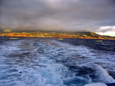
Visto do canal Faial-Pico é muito evidente o Graben de Pedro Miguel, embora possa parecer que a zona central seja mais larga, devido às lombas da Espalamaca e Grande se destacarem mais na paisagem do que as falhas da Lomba dos Frades e da Ribeira do Rato, que são as mais interiores do graben e definem o eixo desta importante estrutura geológica”
O GRABEN
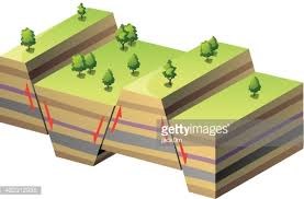
Graben ou fossa tectónicaé a designação dada em geologia estruturala uma depressão de origem tectónica, geralmente com a forma de um valealongado com fundo plano, formada quando um bloco de território fica afundado em relação ao território circundante em resultado dos movimentos combinados de falhas geológicasparalelas ou quase paralelas.
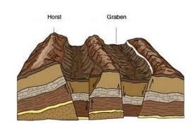
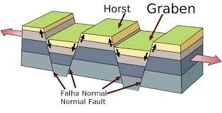
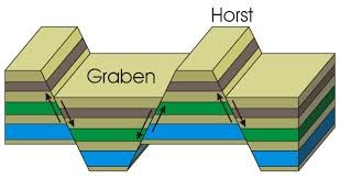
A formação de um graben resulta do afundamento relativo de um bloco, formando uma estrutura que se distingue dos vales de origem erosiva pela presença de escarpas de falha em ambos os lados da zona deprimida. Dada a sua origem tectónica, os graben estão frequentemente associados a estruturas complexas onde se alternam as zonas deprimidas (os graben) e as zonas levantadas (os horst), em faixas com relativo paralelismo. Os graben são estruturas que compõem grande parte das bacias sedimentaresdo mundo.
A palavra "graben" é de origem alemã, língua em que significa escavação ou vala.

Em contextos geotectónicos alargados (isto é em estruturas com centenas ou milhares de quilómetros de extensão) os graben são por vezes designados por vales de rift (ou, aportuguesado, de rifte).
Outra estrutura tectônica relacionada ao Graben é o Hemi-graben, constituído por apenas uma falha geológica (ao invés de duas), basculando um bloco e também gerando uma depressão inclinada.
O graben distingue-se dos vales de origem erosiva pela presença de escarpas de falha em ambos os lados da zona deprimida.
PARA REALIZAR E REGISTAR ESTA EARTHCACHE:
PERGUNTAS:
Para “encontrar/registar” esta cache deverá: provar que esteve no local e responder às seguintes questões, enviando um email/mensagem de Geocaching, com as respostas, em português ou em inglês, para o nosso perfil.
Só depois, de enviar as respostas, e conforme as “guidelines” para as Earthcaches, deverá efetuar o seu registo!
Serão removidos todos os registos que não obedeçam a estes requisitos.
1. Estudando o tema geológico proposto nesta earthcache, responde às seguintes questões:
a) Explica, por palavras tuas, o que é um Graben.
b) Identifica, pelo menos, três outros Graben, localizados nos Açores e pelo menos dois, localizados no continente português.
2. A partir da tua visita ao GZ desta earthcache, responde às seguintes questões:
a) Qual a orientação geral do Graben de Pedro Miguel?
b) O Graben de Pedro Miguel é um graben: simples, duplo ou múltiplo?
c) Por quantas falhas e patamares é formado este Graben?
d) Identifica que outros” fenómenos geológicos”, são observáveis, a partir do GZ.
e) No chão do GZ (rotunda) existe “desenhada” uma Rosa dos Ventos.
Quais os tipos e cores das rochas que constituem esta Rosa?
3. A partir da tua visita ao WP1 (ponto de observação) desta earthcache, responde às seguintes questões:
a) Existe uma construção “humana” no local (WP1). É construída com que tipo de rocha?
b) Qual o comprimento, orientação e inclinação da “escarpa de falha” existente neste local (Lomba Grande)?
4.
TAREFA OBRIGATÓRIA:Deverá tirar uma foto sua, onde você apareça (ou com um papel/placa onde conste o seu nickname e a data da visita) e que comprove a sua presença no GZ desta EC - NÃO META SPOILERS. Esta foto deverá ser colocada no seu registo ou enviada por email ou sistema de mensagens de Geocaching, para o owner!

Não responderemos ao seu contato, a não ser que haja algum “problema” com as suas respostas ou registo.


THE GRABEN
OF “PEDRO MIGUEL”
[FAIAL – AZORES]
ENGLISH

EARTHCACHE
“PEDRO MIGUEL”
Pedro Miguel is a parish in the municipality of Horta on Faial Island, Azores. It occupies a total area of 14.71 km² with 759 inhabitants (2011). It has a population density of 51.6 inhabitants / km². The parish has about 500 registered voters. The Parish of Headquarters is distant of Horta 6 km to the north.
GRABEN OF “PEDRO MIGUEL”
“Graben Pedro Miguel is located in the eastern area of Faial and is a major tectonic and morphological structures of the island.
It is characterized by a prominent staircase, dominated by distensive fault system of general direction WNW-ESE, evidenced by cliffs failure with a maximum height of about 170 me in Caldeira volcano area are covered / hidden by stone deposits pumice and other Holocene tefras.
The graben consists of five levels slaughtered between normal faults, in particular the failure of the “Ribeirinha”, the “Lomba Grande”, da “Ribeira do Rato” “Rocha Vermelha”, the “Espalamaca” and “Flamengos”, reaching the town of “Pedro Miguel” at the central level and more under the graben.
Developing over the last 73,000 (or 40,000) years, the initial genesis of the graben of Pedro Miguel will be associated with the volcano shield of Riverside, either due to deep magma movements associated with magmatic reservoirs, whether extensional tectonic phenomena that affected the Faial island”.
Geoparque Açores
“The Pedro Miguel Graben is the main volcano-tectonic structure of the island and the most impressive of the Azores. It introduces a system of distensive fault WNW-ESE orientation, which gives a topography stepped into the old shield volcano in the eastern part of the island of Faial.
The normal faults are associated with distention movement, ie where the earth surface is extended or as some said to be "stretched".
When normal faults, approximately parallel, lean in opposite directions into space formed between them, it creates a kind of valley bottom more or less wide, and is generated a downed block between failures. To this structure is called Graben in geology, a word of German origin meaning pit or trench.
All post under the name "Faial cut with a knife" and labeled "graben" show parts of a major geomorphological or tectonic structures of Faial, very evident in the eastern half of the island, whose central axis is located in the parish “Pedro Miguel” and called: Graben Pedro Miguel.
In Gabren of Pedro Miguel, show up two failures: the failure of Mouse Ribeira (far right) and the escarpment of the failure of Lomba Grande, both leaning to the south.
When making a modeling relief Faial, the Graben Pedro Miguel stands out immediately as a major depression or valley east of the boiler located in the center of the island.
Visa Faial-Pico channel is very evident the Graben Pedro Miguel, although it may seem that the central area is wider, due to the bumps of “Espalamaca” and “Grande” if more stand out in the landscape than the failures of “Lomba dos Frades” and “Ribeira do Rato”, which are the most interior of the graben and define the axis of this important geological structure”
THE GRABEN
Graben or rift valley,which stands in structural geology to a depression of tectonic origin, usually in the shape of an elongated valley with flat bottom, formed when a land block is sunk to the surrounding territory as a result of the combined failures movements parallel geological or almost parallel.
The formation of a clear from Graben on a block collapse, forming a structure which differs from erosive source by the presence of valleys failure slopes on both sides of the depressed zone. Given its tectonic origin, the graben are often associated with complex structures where alternate depressed areas (the graben) and the raised regions (horst), banded with relative parallelism. The graben are structures that make up much of the sedimentary basins of the world.
The word "graben" is of German origin, language that means excavation or trench.
In broad tectonic environments (i.e. structures with hundreds or thousands of kilometers long) the Graben are sometimes called rift valley (or aportuguesado of rift).
Another tectonic structure related to the Hemi-Graben Graben is constituted by a single fault (instead of two), one tilting pad and also generating an angled depression.
The Graben distinguished from erosive source by the presence of valleys failure slopes on both sides of the depressed zone.
TO PERFORM AND LOG THIS EarthCache:
QUESTIONS:
To "find / register" this cache must: prove that visited the site and answer the following questions by sending an email / message Geocaching, with answers (in Portuguese or in English, only) to our profile.
Only later, sending the answers, and as the "guidelines" for EarthCaches should make your registration! They will be removed from all records that do not meet these requirements.
1. Studying the geological theme proposed this EarthCache, answer the following questions:
a) Explain, in your words, what is a Graben.
b) Identify at least three other Graben, located in the Azores and at least two, located on the Portuguese mainland.
2. From your visit to GZ this EarthCache, answer the following questions:
a) What is the general direction of Graben of Pedro Miguel?
b) The Pedro Miguel Graben is a graben: single, double or multiple?
c) How many failures and landings is formed this Graben?
d) Identify other "geological phenomena" are observable from the GZ.
e) On the floor of the GZ (roundabout) there is "designed" a “Rose of
the Winds”. What types and colors of the rocks that make up
this Rose?
3. From your visit to WP1 (vantage point) of this EarthCache, answer the following questions:
a) There is a "human" building on site (WP1).
It is built with that type of rock?
b) What is the length, orientation and inclination of the "slope failure"
exists at this location (Lomba Grande)?
4.
TASK (not optional): You must take a picture of yourself, where do you show up, (or with a paper / plaque with your geocaching nickname and the date of the visit) and that proves your presence in the GZ of this EC - no spoilers please. This photo must be placed in your log or sent by email or Geocaching messaging system, to the owner!
We do not respond to your touch, unless there is a "problem" with their answers or register.

