La Earthcache / The Earthcache
► Contexte local
Quand on suit le cours de la Loire dans son parcours inférieur, on peut soudain voir apparaître au détour d'un méandre un fier monument dressé sur le bord du fleuve, la tour d'Oudon.

Ce Château fort du XIVeme siècle, du haut de ses 32 mètres, veille sur le fleuve royal et ses richesses.
Pourquoi avoir choisi cet emplacement pour un aussi fier édifice ?
Cette explication tient en partie à l'étude de son assise, qui prend place sur un affleurement rocheux qui domine toute la vallée de la Loire, à la confluence avec une autre rivière, le Hâvre.
Celui-ci est en effet constitué, comme l'indique la carte BRGM, d'un sous-jacent d'amphibolites veinées de micashistes, deux roches métamorphiques dont nous allons étudier quelques particularités.

► La roche d'Oudon
L’amphibolite
L'amphibolite est une roche banale métamorphique, qui a pris naissance d'une roche plutonique (gabbros, dolérites) ou d'une roche volcanique basique ayant subit un métamorphisme.
A Oudon, ces amphibolites peuvent dériver soit de gabbros à grain fin, soit de basaltes.
Ces roches très sombres se présentent en lits réguliers et ont une débit parallépipédique.
L'amphibolite est dure, généralement bi-minérale, montre une association de plagioclaste moyen et de hornblende verte, qui lui donne cette couleur bleu-vert très sombre.
La roche d'Oudon présente même une forme prasinite, c'est à dire l’apparence d'une roche métamorphique dérivant du gabbro, à débit schisteux, de couleur verte, riche en amphibole, épidote, chlorite.
L'amphibolite du soubassement de la tour de Oudon alterne par endroits avec de fines veines de micaschistes.
Le micaschiste
Ces micashistes présentent une couleur beaucoup plus claire (du fait notamment d'une forte présence de micas de type biotite ou muscovite), et sont des roches plus tendres.
Ces roches métamorphiques sont d'origine sédimentaires, qui dérivent d'argiles et de pélites. Les pélites désignent des roches sédimentaires détritiques à grain très fin (essentiellement des minéraux argileux, avec quartz, micas, mais peu de feldspaths).
Ces différentes roches ont été soumises à des phénomènes tectoniques compressifs qui expliquent leur formation, mais qui ont aussi poussé à un bouleversement des strates de roche entraînant l'apparition de plis caractérisés par un pendage.
► Pendage d'une roche métamorphique
Pour qualifier un pendage d'une couche de roche litée, comme les roches métamorphiques, il faut deux valeurs :
- l'inclinaison des lits par rapport à un plan à l'horizontale, exprimée en degrés.
- la direction du pendage, qui se mesure à 90 degrés de la direction de la couche et définit un angle par rapport au Nord.

L'intensité du pendage peut être graduée de la façon suivante :
- le pendage est nul si le plan (ou la ligne qui lui correspond) mesuré est horizontal. Dans ce cas, il n'y a pas de direction, ou plutôt, le plan est dans toutes les directions.
- le pendage est faible si le plan (ou la ligne) mesuré est presque horizontal (moins de 30 degrés).
- le pendage est fort si le plan (ou la ligne) mesuré est presque vertical (plus de 60 degrés).
- le pendage est dit vertical, si le plan (ou la ligne) mesuré est verticale. Dans ce cas, il n'y a pas de direction pour une ligne, mais il y a une (ou plutôt deux) direction pour un plan.
► Local context
When you follows the course of the Loire River in its lower course, you can suddenly appear at the bend of a meander a proud monument standing on the riverbank, the tower of Oudon.
The Castle of the XIVth century, from its height of 32 meters, watches over the Royal River and its riches.
Why did you choose this location for such a proud building?
This explanation is partly due to the study of its base, which sits on a rocky outcrop which dominates the Loire Valley, at the confluence with another river, the Havre.
This is indeed made, as indicated by the BRGM card, underlying veined with amphibolite and micashistes, two metamorphic rocks which we will study some peculiarities.
► Oudon's rock formation
Amphibolite
The amphibolite is a common metamorphic rock, which originated from a plutonic rock (gabbro, dolerite) or a basic volcanic rocks that have undergone metamorphism.
Amphibolites of Oudon can drift either fine-grained gabbro or basalt.
These rocks appear very dark in regular beds and have a parallelepiped flow.
The amphibolite is hard, usually bi-mineral shows an association means plagioclaste and green hornblende, giving it the blue-green color very dark.
The rock of Oudon present even prasinite shape, ie the appearance of a metamorphic rock derived from gabbro, schist to flow, green, rich amphibole, epidote, chlorite.
The amphibolite underbody Oudon tower alternate with thin veins of micaschist.
Micaschist
These mica schists have a much clearer color (due in particular to a strong presence of biotite mica type or muscovite) and are softer rocks.
These metamorphic rocks are sedimentary origin, derived from clays and mudstones. The mudstones designate clastic sedimentary rocks with very fine grain (mainly of clay minerals with quartz, mica, but few feldspar ).
These rocks were subjected to compressive tectonic phenomena that explain their formation, but also push for an upheaval of rock strata resulting in the appearance of wrinkles characterized by a dip.
► Dip of metamorphic rock
To qualify the dip of a layered rock, like metamorphic rocks, it takes two values:
- The inclination of the beds with respect to a plane to the horizontal, in degrees.
- The direction of dip, measured at 90 degrees to the direction of the layer and defines an angle to the North./span>
The intensity of the dip can be graded as follows:
- Dip is zero if the plan (or the line that corresponds to it) measured is horizontal. In this case, there is no direction, or rather, the plan is in all directions.
- Dip is low if the plan (or line) is measured almost horizontal (under 30 degrees).
- Dip is strong if the plan (or line) is measured almost vertical (over 60 degrees).
- Vertical dip is said, if the plan (or line) is measured vertically. In this case, there is no direction to a line, but there is one (or rather two) direction to a plan.
► Sources bibliographiques / Bibliographical sources
Les Questions / The Questions
La lecture attentive du descriptif de la cache, ainsi qu'une observation des éléments de terrain et un peu de déduction sont normalement suffisants pour répondre aux questions de cette EarthCache.
A careful reading of the description of the cache, as well as observation of terrain features and some deduction is usually sufficient to answer questions of this EarthCache.
Questions pour valider :"La Tour d'Oudon"
Questions to validate: "Oudon's tower"
Point 1 : N 47° 20.697 W 001° 17.399
Vous voici devant une saillie rocheuse qui prolonge le soubassement de la tour d'Oudon.
Here you are in front of a rocky ledge that extends the base of the tower of Oudon.
- Question 1 : Etudiez la roche à cet endroit et détaillez ses caractéristiques : coloration, dureté, roche litée ou grenue, forme du débit de la roche. Que pouvez-vous en déduire sur sa nature ?
- Question 1 : Studying the rock here and detail its characteristics: color, hardness, layered rock or granular forms of the rock flow. What can you deduce about its nature?
- Question 2 : Mesurer la largeur L de la couche de la photo ci-dessous (partie zoomée).
- Question 2 : Measure the width L of the layer of the photo below.
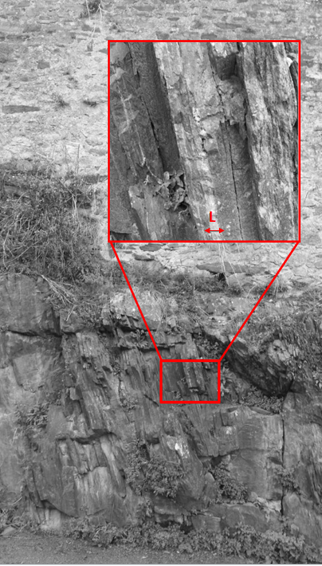
- Question 3 : Déterminer le pendage (inclinaison et direction) des couches de ce point. Comment pouvez-vous qualifier ce pendage ?
- Question 3 : Determine the dip (inclination and direction). How can you describe this dip?
Point 2 : N 47° 20.698 W 001° 17.393
Sous la zone rouge de la photo ci-dessous, la roche étudiée au WP 1 alterne avec une autre roche en couches beaucoup plus fines.
Under the red zone of the photo below, the rock studied in WP1 alternates with another rock in much thinner layers.
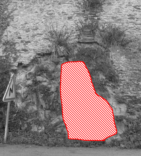
- Question 4 : Étudiez cette nouvelle roche et détaillez ces caractéristiques : coloration, dureté, litage. Que pouvez-vous en déduire sur sa nature ?
- Question 4 : Study this new rock and detail these characteristics: color, hardness, bedding. What can you deduce about its nature?
Vous pouvez vous loguer sans attendre notre confirmation,
mais vous devez nous envoyer les réponses en même temps soit par mail via notre profil (
fafahakkai), soit via la messagerie geocaching.com (Message Center).
S'il y a des problèmes avec vos réponses nous vous en ferons part.
Les logs enregistrés sans réponses seront supprimés.Une photo de vous ou de votre GPS en Noir&Blanc avec la tour d'Oudon en arrière plan serait la bienvenue, mais n'est pas obligatoire.
You can log this cache without waiting for our confirmation, but you must send us the answers at the same time, by e-mail via our profile (fafahakkai) or by the system of Message Center of geocaching.com.
If there is a problem with your answers we will notify you. The logs recorded without answers will be deleted.
A photo of you or your GPS in Black&White with the Tower of Oudon in the background would be welcome, but is not mandatory.
Rappel concernant les « Earthcaches »: Il n'y a pas de conteneur à rechercher ni de logbook à renseigner. Il suffit de se rendre sur les lieux, de répondre aux questions ci-dessus et de nous renvoyer les réponses.
Reminder concerning "Earthcaches": there is neither a container to look for nor a logbook to sign. One need only go to the location, answer to the differents quiestions and send us the answers.