Cache Across Maryland 2016
The Maryland Geocaching Society and the National Park Service welcome you to the 2016 edition of Cache Across Maryland! In commemoration of the 100th Anniversary of the National Park Service, the MGS and the NPS have joined together in presenting CAM 2016 in ten National Park locations throughout the state of Maryland. From the mountains of Western Maryland to the Atlantic Ocean, Cache Across Maryland 2016 will demonstrate that Maryland truly is “America in Miniature”.
This is one of ten geocaches placed in National Parks for Cache Across Maryland 2016. Each geocache contains a code which you will use to determine the location of the CAM 2016 Picnic to be held on May 14th. The code can be found on the side of the cache container and inside the front cover of the logbook. Don't forget to record this code! Any geocacher who has completed all ten CAM geocaches and attends the CAM Picnic on May 14th will receive a Certificate of Completion and a Cache Across Maryland 2016 Geocoin. We hope you enjoy a very special CAM 2016!

Assateague Island National Seashore
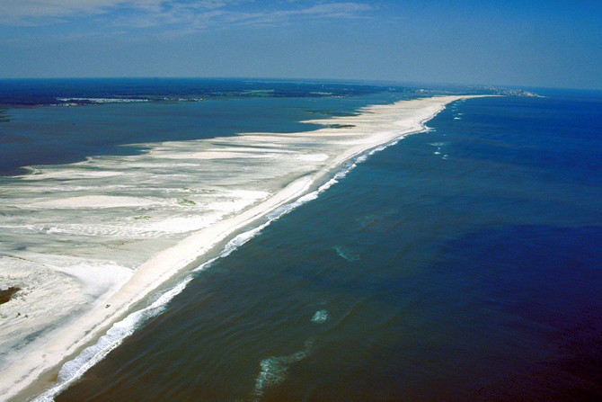
Assateague Island National Seashore is a unit of the National Park Service occupying about half of Assateague Island, located off Maryland's eastern shore on the Atlantic Ocean. The park covers an area of 41,320 acres. The portion of the island designated as national seashore extends from the Ocean City inlet to the Maryland/Virginia state border. Over 2.1 million people visit the park each year. The park was created in 1965 after a strong nor'easter (the Ash Wednesday Storm of 1962) destroyed the planned, but never built, resort community of Ocean Beach, Maryland. The national seashore is famous for its white sand beaches and wild ponies.

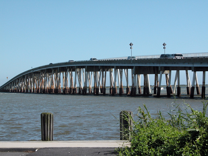
The park is located on a barrier island shaped by the stormy seas and gentle winds along the coast of the Delmarva Peninsula. The island is approximately 37 miles long, yet never more than a mile wide. The park is divided into the Maryland District in the north and the Virginia District in the south. It is not possible to drive down the island from one district to the other. All automobile traffic must enter the mainland before traveling to the other end of the island. The Maryland District of Assateague Island National Seashore runs from the Ocean City Inlet in the north to the Virginia state line. This district contains a visitor center, campground, three nature trails, a life guarded beach, and the park's headquarters. The smaller Assateague State Park sits within the borders of this district. The only access to the Maryland district (and the state park) is via the Verrazano Bridge on Maryland Route 611.
Assateague Island is part of a chain of barrier islands that extend from Maine to Texas. The island is built from sand that moves south via longshore drift to distribute sand along the island's length. The source of the sand is run-off from the Appalachian Mountains. The island is moving westwards, the result of rising sea levels and waves rolling over the island during storms. This condition is most pronounced at the northern end of the island, where Ocean City's jetties have stabilized the islands north of the Ocean City Inlet and have starved Assateague of new sand. As a result, Assateague's beach is shifted several hundred meters westwards compared to Ocean City's. The inlet was formed during the 1933 Chesapeake–Potomac hurricane, separating Fenwick and Assateague islands, and a jetty was immediately constructed to stabilize the inlet. After severe nor'easters in 1998, a sand replenishment program was undertaken to restore a sand supply to the north end of Assateague and to ensure a continuing supply.
Before the national seashore was created in 1965, the island was going to be turned into a private resort community called Ocean Beach, Maryland. Some 5,000 private lots comprising what is now National Park Service property were zoned and sold for resort development in the 1950s. However, the Ash Wednesday Storm of 1962 halted the plans for development. The nor'easter destroyed the few existing structures on the island that had been built and ripped the roads apart. Realizing that the island was too unstable to build upon, the housing development firm sold all of its land to the federal government.
Since the park's creation, several improvements have been made to aid the public in recreation. The park maintains a two-mile stretch of road on the island that travels through the state park in order for visitors to reach the National Seashore. The park supports many recreational activites: camping, hiking, swimming, fishing, and an over-sand vehicle zone. A new visitor center was built in 2010 which is located on the mainland before visitors cross over the bridge to get to the island. The visitor center hosts several ranger-led programs and exhibits for the public. The park service also opened a new ranger station on the island in 2012. The building is powered by new solar panels that built in a nearby parking lot.
The national seashore provides habitat for a variety of plants and animals adapted to the coastline environment. The coastal salt marsh environment attracts wading birds, seabirds and amphibious mammals, as well as animals that have adapted to the harsh environment. Shorebirds and wading birds are abundant at Assateague. Breeding birds include piping plovers, great egrets and red-winged blackbirds. Seabirds include brown pelicans and several species of gulls and terns. Wooded habitats shelter ruby-crowned kinglets and white-eyed vireos. During the winter the area shelters northern birds, including brant geese and northern saw-whet owls.
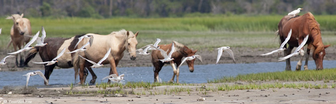
Bands of feral horses, commonly known as a Chincoteague Pony or an Assateague Pony, freely roam on Assateague Island. Although local legend claims that the horses are descendants of animals that survived a shipwreck on the coast, it is more likely that the horses are descendants of domestic horses confined on the island by local residents in lieu of fencing them in on the mainland, where fences were taxed. The salty low-nutrient diet of saltmarsh grasses has resulted in the ponies' short stature and bloated abdomens.
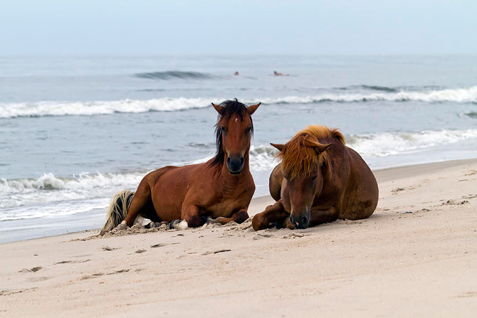
Two herds are kept separate by a fence at the Maryland-Virginia border. The horses in Virginia are kept in large corrals and owned by the Chincoteague volunteer fire company. These are the famous ponies that are herded every July and then swim to nearby Chincoteague Island as a fundraiser. In order to ensure healthy ponies to auction off, the firefighters provide them with food, water, and vet care. The Maryland herd is treated as wildlife and are not rounded up or removed from the island, nor do they receive veterinary care. The Park Service uses birth control to manage the herd size, injecting a vaccine using darts to control pregnancy and to keep the size of the herd under 125 ponies.
The Geocache
This geocache is not located at the listed coordinates. At Reference Point 1 and Reference Point 2 you will find the information you need to solve for A through F to determine the coordinates to the final.
At Reference Point 1: [N38° 14.854, W075° 09.288]
- “Caring for the Bay” refers to the “Sinepuxent Bay ______”
A = the number of letters in the ‘blank’
- “Sheltered Waters”
B = the number of bays that start with the letter ‘C’
- “A Productive Nursery”
C = the shallowest depth, multiplied by 3
At Reference Point 2: [N38° 14.741, W075° 08.990]
- “Doing Our Part”
D = the number of crabs named on the sign
- “Almost Developed”
E = the tens digit in the price of a lot
- “Going Natural”
F = the number of letters in the revegetatedplant that restored natural tidal flows
The geocache is located at N38° 14.ABC, W075° 09.DEF
The checksum of ABCDEF is 35.
The geocache is a large clear jar.
The Maryland District of Assateague Island is open year round, 24 hours a day. The Assateague Island Visitor Center is open all year from 9am–4pm except for Thanksgiving Day and Christmas Day. During January and February, the Visitor Center is closed on Tuesdays and Wednesdays. The Visitor Center hosts aquariums, a touch tank, exhibits, maps, and a film about the island’s wild horses. No fee is required to find the cache or to enter the Visitor Center. The cache is accessible from sunrise to sunset.
To learn more about Assateague Island National Seashore, visit these new EarthCaches:
- GC69CRE · Assateague: Island of Renewal (N38° 14.854, W075° 09.288)
- GC69H6P · Assateague Island: Life on the Edge (N38° 12.494, W075° 09.040)
The Maryland Geocaching Society extends its thanks to the National Park Service for participating in Cache Across Maryland 2016 and for allowing us to partake in its centennial celebrations. Geocaches may only be placed on National Park Property at the direction of National Park Service staff.