Cache Across Maryland 2016
The Maryland Geocaching Society and the National Park Service welcome you to the 2016 edition of Cache Across Maryland! In commemoration of the 100th Anniversary of the National Park Service, the MGS and the NPS have joined together in presenting CAM 2016 in ten National Park locations throughout the state of Maryland. From the mountains of Western Maryland to the Atlantic Ocean, Cache Across Maryland 2016 will demonstrate that Maryland truly is “America in Miniature”.
This is one of ten geocaches placed in National Parks for Cache Across Maryland 2016. Each geocache contains a code which you will use to determine the location of the CAM 2016 Picnic to be held on May 14th. The code can be found on the inside wall of the host container and on the inside front cover of the logbook. Don't forget to record this code! Any geocacher who has completed all ten CAM geocaches and attends the CAM Picnic on May 14th will receive a Certificate of Completion and a Cache Across Maryland 2016 Geocoin. We hope you enjoy a very special CAM 2016!

Hampton National Historic Site
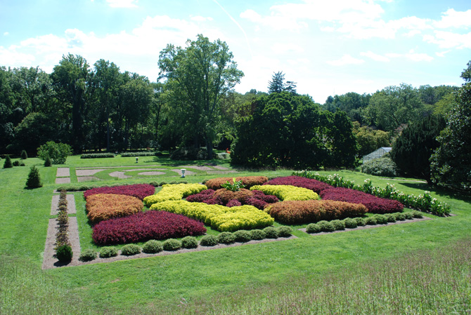
Standing on a hill overlooking terraced gardens, exotic trees, and green lawns, Hampton National Historic Site invites visitors to explore what life was like on the Hampton estate beginning in the late 18th century. Captain Charles Ridgely directed the construction of his Georgian style mansion between 1783 and 1790. In 1790, the house was the largest in the United States. Captain Ridgely and many of Hampton’s later masters used the vast grounds of the Hampton estate to amass great earnings and wealth. At its peak, Hampton had 25,000 acres with ironworks, grain crops, beef cattle, thoroughbred horses, coal mining, marble quarries, mills, and other mercantile interests.
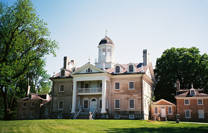
Hampton Mansion is considered one of the finest examples of late Georgian style architecture in America. The mansion’s design was likely conceived through collaboration between Captain Ridgely and Jehu Howell, a local carpenter and highly skilled builder. Howell used local stone and stucco to construct this classically symmetrical Georgian mansion; the three story building, with its wide porticos, is connected to two smaller two-story wings on either side via hallways. It is believed that Ridgely paid Howell nearly 3,500 British pounds and 68 quarts of rum for his work.
Following the childless Captain, Charles Ridgely Carnan inherited the largest part of Hampton’s land and business, under the condition that he take Ridgely as his surname. Like his uncle, Charles Ridgely Carnan was an astute businessman who worked to make Hampton estate a grand showplace. Charles Ridgely became governor of Maryland. Upon his death in 1829, Governor Ridgely owned at least 339 enslaved African Americans. In his will, he freed his slaves upon his death but imposed many specific stipulations dictating their freedom, including variables such as age and sex.
As the third master of Hampton, John Ridgely inherited the estate with only a small remaining enslaved population. He purchased about 77 slaves to work around the estate. John Ridgely and his wife Elize Ridgely were the last slave owners at Hampton. Noteworthy for the time, money, and attention they devoted to the gardens, they enhanced the landscape by bringing in exotic trees and designing terraced gardens. Visitors can take self-guided tours of John and Elize Ridgely’s planned landscape on the grounds of the estate.
After the end of the Civil War and the abolition of slavery, the remaining masters, Charles Ridgely, John Ridgely, and John Ridgely Jr, could no longer rely on slaves to ensure that the plantation ran smoothly. Hampton began to decline, even as its masters sought to maintain the aristocratic traditions that had become synonymous with the estate. The Sixth Master, John Ridgely Jr, sold the estate to a Mellon family trust, which donated it to the Federal Government. This ensured the preservation and interpretation of the mansion, 60 acres, and the historical narratives associated with the estate.
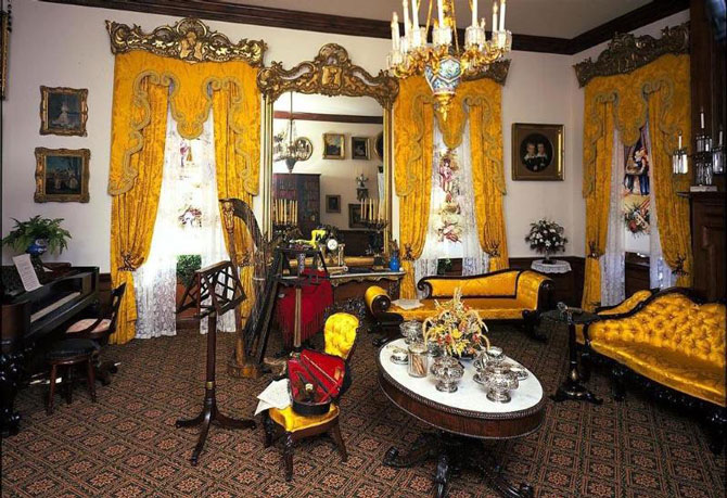
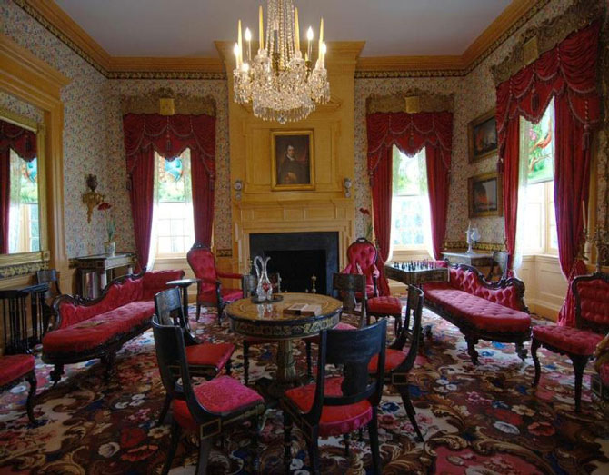
Today, visitors to Hampton National Historic Site can take a guided tour to see the mansion with its high 13-foot ceilings and different Ridgely masters’ furnishings including oil paintings by American artists, large gilded mirrors, and a variety of imported furniture. The public can experience what it was like to live in a grand Georgian style mansion on a vast estate from the late 18th until the early 20th centuries, and learn about what life was like for the Ridgely family and the slaves and indentured servants who were essential to the running of the plantation.
The Geocache
This geocache is not located at the listed coordinates. This is a six-stage puzzle cache designed to give you a brief tour of the Hampton Estate. At each of the first five stages you will find an information sign. Use these signs to solve for A through F to determine the coordinates to the final location.
The signs can be visited in any order, however finding them in numerical order follows the easiest route through the estate when walking. Signs 4 & 5 are located in the north section of the estate located on the north side of Hampton Lane. Please use the ‘Crosswalk’ waypoint and be extremely careful of traffic when crossing Hampton Lane. This north section has a small parking lot (‘North Parking’ waypoint) for those who prefer to drive there. In this case, it would be practical to find signs 4 & 5 first, and then proceed to Main Parking for signs 1–3 and the final. The entire walk and back is about 1.5 miles.
- SIGN 1:
N39° 24.972, W076° 35.419
A = the number of British souvenirs at the mansion
- SIGN 2:
N39° 24.971, W076° 35.321
B = the third digit in the year of his death
- SIGN 3:
N39° 25.010, W076° 35.281
C = the second digit of the feet below ground
- SIGN 4:
N39° 25.234, W076° 35.230
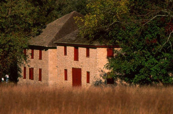
D = the second digit of the year of the Corncrib
- SIGN 5:
N39° 25.185, W076° 35.172
EF = the last 2 digits of the year the dairy was constructed
- FINAL:
The geocache is located at N39° 24.DCB, W076° 35.AEF
The checksum of ABCDEF is 23.
The geocache is a clear lock-n-lock container.
The grounds of Hampton are open daily from 8.30am–5pm except on Thanksgiving day, Christmas day and New Year's Day. The gravel roads are open to pedestrians from sunrise to sunset. The Visitor Center is open Thursday through Sunday from 10am–5pm, and the Hampton mansion is open for tours on Saturday and Sunday. The hours change seasonally, so please check the NPS website for up-to-date hours of operation and mansion tour schedule. Hampton National Historic Site does not charge any entrance of visitor fees.
The Maryland Geocaching Society extends its thanks to the National Park Service for participating in Cache Across Maryland 2016 and for allowing us to partake in its centennial celebrations. Geocaches may only be placed on National Park Property at the direction of National Park Service staff.