Important Note: Most of these homes / buildings are PRIVATELY owned, so PLEASE be respectful. I've chosen questions that should allow you to observe the location from a distance (you shouldn't need to leave your car) and to be discreet, so you shouldn't have to worry about causing any issues. Be respectful, and you should get the same in return.

Spring City Early History:
Spring City is one of the most interesting towns in all of Sanpete County. Mormon colonists founded Springtown along Canal Creek in 1852. About forty Danish families joined the settlement giving it another name, Little Denmark. A fort was built, and settlers moved in from nearby Fort Hambleton (later Mount Pleasant) for protection from hostile Indians. Eventually, people left and moved to Manti. After the village was abandoned, the fort was burned.
Soon though several original founders of Springtown or Spring City returned to create a permanent town. Difficulties with local Indians continued until a resolution was reached in 1867. Spring City then grew, reaching a population of 850 in 1880. By 1900, Spring City reached its largest population of 1,230 people. This was roughly twice its present size.
Early Economy
Since its settlement, Spring City depended primarily on farming and raising livestock. Early settlers distributed land, dug irrigation ditches, farmed, harvested lumber, and raised cattle and sheep. With the arrival of the Rio Grande Western Railroad, Spring City’s economy grew. It exported local products including native oolite stone, which was shipped to larger northern cities for use in the construction of fine buildings.
 Diversity
Spring City was settled by Mormons but was also home to Presbyterians, Methodists, Adventists and other religions. As the town grew, its residents built meetinghouses, schools, an amusement hall, a small group of business buildings along Main Street, and more than 200 residences in both Scandinavian and various American architectural styles.
One of its greatests assets are the historic buildings that Spring City has that still stand today. Since the population of Spring City decreased from 1900 to 1970, there was little reason to destroy older structures. Spring City’s LDS meetinghouse, or tabernacle, city halls, Victorian elementary school, and bishop’s storehouse are among its most important public buildings. Many public buildings and homes are examples of early log, adobe, and frame structures. Historic “urban” barns and other agricultural and livestock outbuildings sit within a few hundred feet of Main Street.
Historical District
The town of Spring City was listed as a historic district in the National Register of Historic Places. In the mid-1970s, many buildings were restored both by local residents and by interested newcomers. Renovation has continued, and vacant buildings have now become business offices, stores, cultural centers, family homes, and artist studios. The restoration of historic buildings in Spring City has attracted many visitors and new residents resulting in a growth in population.
Today
Like many Utah cities, Spring City strives balance the needs of all citizens as it continues to grow while preserving the historical character of the community. Today Spring City can be quite the tourist trap, with numerous amazing Bed & Breakfast establishments, several annual festivals and celebrations during the summer months, like the Heritage Days (usually in May), the Bluegrass Festival (held the end of July / early August), and many other such activities. One of the more interesting recent developments in Spring City is the incredible growth of the local art scene, and you can see some of this art showcased at the Plein Art Festival (beginning of September) for example and elsewhere in any one of several art galleries in Spring City.

One of their more interesting events is the annual Historic Pioneer Home Tour, which is part of the Heritage Days. This gives you the rare chance to visit and go inside these beautifully restored historic homes that are privately owned, so normally they are not open to the public. However, this is an opportunity that happens just once a year, so if you are interested, don't miss it!
Thus while Spring City has a rich history, it is by no means a town stuck in the past. Come check out this vibrant and thriving community that has balanced the past & present in a uniquely Sanpete way.
Geocache Explanation:
The geocache is NOT at the given coordinates. However, you can start at the coordinates (it is the first stage, after all). To find the cache, all you have to do is visit each site* (labeled A B C D E & F), and then replace that letter in the Final Coordinate Puzzle with the number you discovered. After visiting all 6 sites, you'll know where to get the final cache! Also, if you want to see more of Spring City, check out all of the Spring City Tour Caches:
NOTE: Caches 2, 3 and 4 are NOT part of the official Utah Geotour, nor does finding them go towards earning the county patch, but are simply for your finding pleasure.
Final Coordinate Puzzle:
Here are the coordinates for the final cache (where you'll actually find it):
N 39° 28._ _ _ '
A B C
W 111° 29._ _ _ '
D E F
Each letter represents a missing coordinate / number (which will range from 0-9). Figure out the answer and you’ll have your missing number! Note: if any of your equations end up with a negative number, ignore the negative sign.
Below are the different sites,and all are included as waypoints. Happy hunting, and enjoy your visit to Spring City!
Sites and Question List: If you would like a printable copy of this, check this link here.
Site A: Spring City Public School, 1899: 45 South 100 East
Question: What are the words located on the front of the building above the door and the year (1899)?
- "Built" = 5
- "Established" = 6
- "Public School" = 7
- "Erected" = 8
 Site B: John Blain House, C. 1880: 385 East 100 South
Question: Where is the main (south facing) front gable located?
- On the left / West side of the house, over the door = 1
- On the right / East side of the house, above the largest window = 2
- In the middle, directly above the front door = 3
- In the middle, directly over the largest window = 4
Site C: Endowment House / Schoolhouse, 1876: 63 West 300 South
Question: There is an inscription above the door, with a picture of something: What is it?
- A Crescent Moon = 5
- A Beehive = 4
- The All-seeing Eye of God = 3
- A 5-pointed star = 2
Site D: Andrew & Sena Thompsen, C. 1886: 488 North 200 East
Question: What was the exterior of this house made of?
- Oolite Limestone = 4
- Logs = 6
- Wooden siding = 5
- Adobe = 7
Site E: Crisp-Allen House, 1881-1884: 59 North Main
Question: How many panels are in each of the front windows (total for one window, not ALL of them; each have the same number, however)?
- (# of panes - 11) = (the correct coordinate / number)
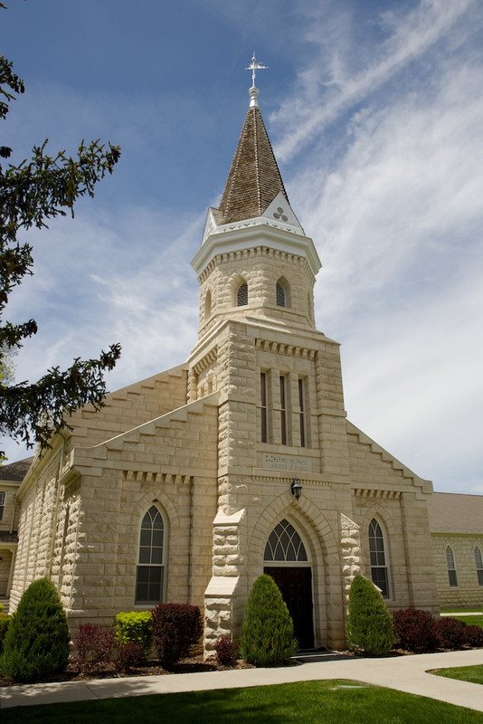
Site F: Spring City LDS Chapel, 1902-1911: 164 South Main
Question: How many wooden panes / squares (like window panes, only not of glass) are there on each of the front doors (hint: both doors have the same # of panes)?
- (# of panes - 6) = (the correct coordinate / number)
We certainly hope that while here, that you have fun, and best of luck!
Final Coordinate Puzzle:
Again, here are the coordinates for the final cache (where you'll actually find it):
N 39° 28._ _ _ '
A B C
W 111° 29._ _ _ '
D E F
Want to check your work?
- Sum Check: Once you’ve figured out what numbers the letters represent, add up all 6 numbers, and it should equal = 31 (thirty-one)
- Or, you may use the geochecker link and plug in the coordinates you've figured out, to see if you are correct (Note: requires an internet connection)
- Note: after finding the cache, please make sure to return it snuggly into its hiding place, so that the lid closes correctly. Thanks for your help in keeping it safe from muggles!
One Last Note: Most of these homes / buildings are PRIVATELY owned, so please be respectful. I've chosen questions that should allow you to observe the location from a distance and to be discreet, so you shouldn't have to worry about that. Be respectful, and you should get the same in return.
*These sites are pointed out in Spring City: A Guide to Architecture and History, a very helpful guide for exploring Spring City that you can find for $5 or less most anywhere in town. Much of the info I used came from this guide, and I've only included a fraction of the sites mentioned in it as waypoints. This tour wouldn't have been possible without this guide, so I'm giving credit where credit is due.
Sanpete County
Sanpete is a very unique place, and there's lots to do and see. Right thru the middle of it runs the Mormon Pioneer National Heritage Area, following US-89 from Fairview all the way south to Kanab and beyond (for more info, see: their website, here's a guide to the entire area, & this video highlighting the area).
Sanpete is also home to the famed Arapeen ATV Trail, a very popular recreation destination; here's a link to a map, and a video to learn more. And if you haven't visited Palisade State Park, it is worth a visit; check out their website or watch this video for more info. We hope you have fun exploring Sanpete as you check out these geocaches and beyond, and we certainly hope to see you again soon!