This Earthcache brings you to a parking area inside the Prince Edward Island National Park of Canada at MacNeill's Brook. During the summer season there is a fee to enter and support the park. Thank you to the Prince Edward Island National Park of Canada for permission to place this Earthcache.
For more information on PEI National Park click here: http://www.pc.gc.ca/eng/pn-np/pe/pei-ipe/visit
Please respect the park, the rules, and CITO - do not litter.
Once the park’s season is finished, access to the area is still available and free of charge. Wheelchairs and strollers will be able to wheel over to the fence area (reasonably flat land) in order to view the waves and beach to answer these questions.
BEWARE of children and pets at all times due to the high cliffs near the beach and any sand erosion near the stairs.
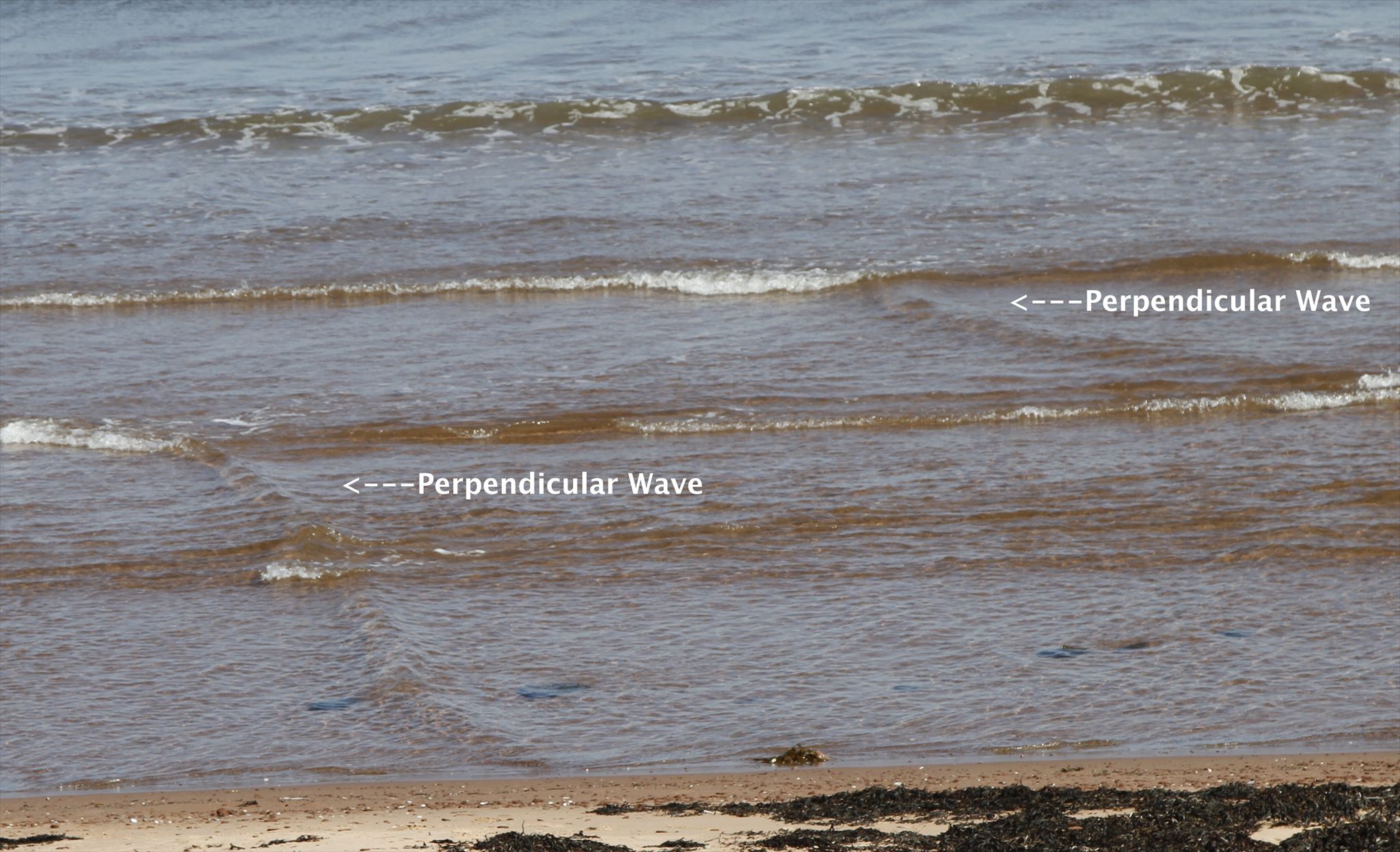
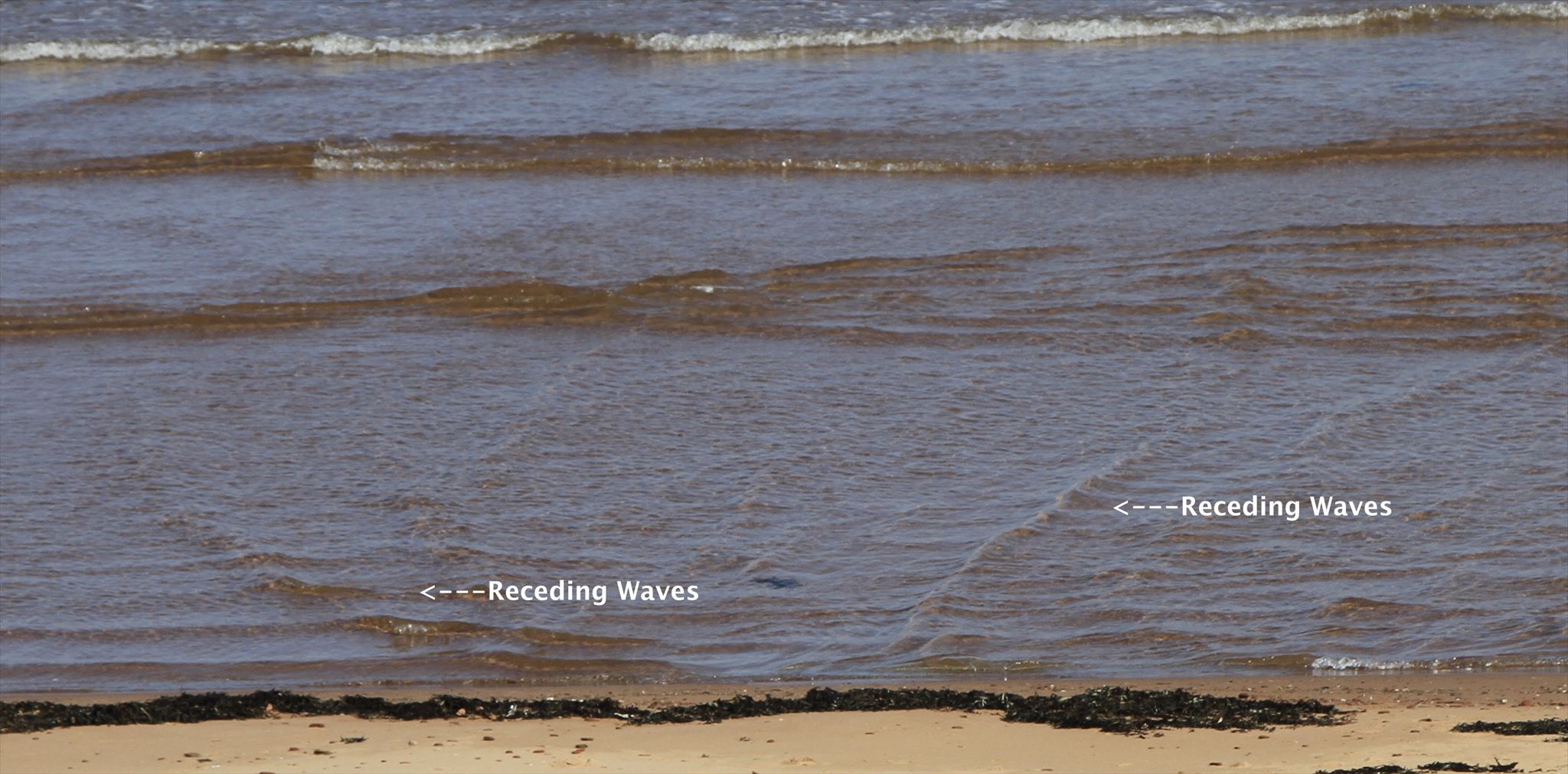
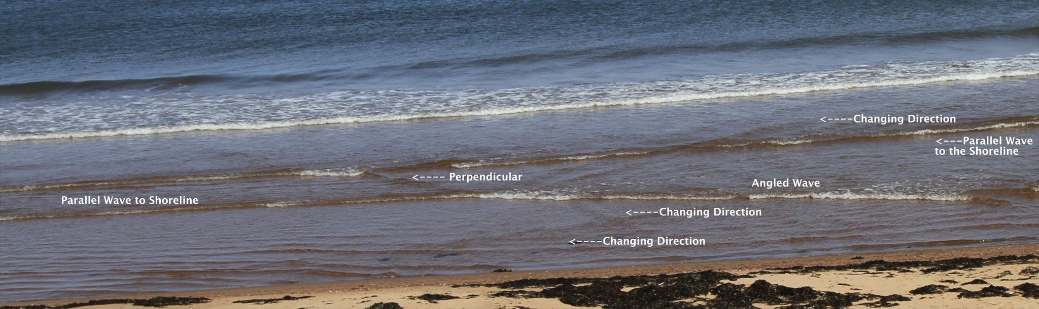
Following the above coordinates, you will arrive at the top of the staircase. You can complete this Earthcache without descending the steps and spending a few minutes observing the nature of the waves and beach area. It was at this location we watched in awe at the ocean’s wave breaking patterns AT the shoreline. We have never observed these backwash/sidewash waves before occurring in one area in different directions at the same time. Here we observed waves moving perpendicular to the shoreline from right to left and learned about sidewash. We also observed receding waves meeting incoming waves creating a moving line of shooting spray that raced along the intersection, very cool on video. Please read carefully:
Here is what we photographed:
Wind Wave~
A wave is the movement of wind’s energy travelling through a water medium. The water’s movement is up and down. The waves of the water themselves do not move horizontally.
Wave Formation~
The type and size of waves created are determined by these influences: wind speed, water depth, wind duration, uninterrupted distance the wind travels without changing direction (called fetch), width of the area affected by the fetch
Types of Wind Waves~
A. Capillary Waves/Ripples – created by light local winds, stop when the local winds stop blowing.
B. Wind Sea – larger waves generated and affected by local winds last longer even after the local winds have died down. Gravity helps them grow.
C. Swells/Surface Gravity Waves – created by distant weather systems, not affected by local winds, travel long distances.
Beach Formation~
Beaches are formed by wave and wind action eroding the land and/or rocks offshore and depositing these loose sediments of sand, rock, gravel, and pebbles. The particles settle and compact. Smaller sized sand particles produce flatter beaches.
The shape of the beach is determined by the wave action.
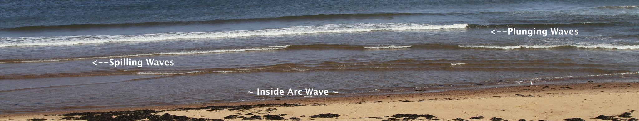
Constructive waves (spilling/rolling waves)~ at the shoreline form beaches. They are short in height and have a long wavelength. The frequency is between 6 and 8 waves per minute. Waves are constructive when there is enough time before the next wave hits to allow the depositing of materials to settle. These materials compact when the receding water from the wave soaks into the beach. These compacted beaches are more resistant to erosion and further wave action.
Destructive larger waves (plunging or dumping waves) ~ at the shoreline destroy beaches removing the shoreline particles. These kinds of waves are high in height and have a short time between crests. The lighter sediments in the water do not have time to be deposited and settle before being carried away by the next wave. The frequency is with between 13 and 15 waves per minute. The strong downward energy and backwash aids to erode beaches and cliffs.
Wind also creates beaches and sand dunes. The wider the beach area the more wind, smaller sand particles and sand dunes tucked in behind the beach area. The narrower the beach, the larger the particles of sand and no sand dunes will be present.
High-Energy (Dissipative) Beaches~
These beaches are gentle sloping and have small sand particles. The wave energy is dissipated and spread out over a large wide area. Large waves return the water seaward without rip currents.
Low-Energy (Reflective) Beaches~
Small waves form these beaches that are steep and narrow with big sand or gravel particles. Plunging waves break on these shorelines often forming cuspate (pointy) features.
Sandbar Formation~
Sandbars on the ocean floor are created when waves move sand and deposit it changing the seafloor height.
Breaking Waves~
Near the shoreline when waves meet land or rock and break the area is called Point Break. Waves can break-over towards the left, right or in both directions from a central point. Waves break as the bottom part of the moving energy wave hits the bottom of the shoreline floor first resulting in the inability to support the top of the wave that quickly overtakes the bottom of the wave and breaks onto the coast. There are two main kinds of wave break actions depend on the shoreline slope and shape.
Spilling/Rolling – most common on a gentle slope at the shoreline dissipating its energy evenly over a large area.
Plunging/Dumping - these waves have strong offshore winds and long wave periods, common when there is a sudden rise in the seafloor, found on steeper shorelines, it curls over a pocket of air. This plunging type of wave can happen further out as the wave hits a sandbar or closer inland at the shoreline if the angle of the sandbar is steep.
Wave Refraction~
Wave refraction (a bending and angling of the wave line) occurs often when waves approach the shore. This can occur for a few reasons: the sandbar depth changes, the shoreline is uneven, or the wave needs to flow around an obstruction. Wave refraction happens when part of the wave hits an obstruction sooner than other parts of the wave slowing its velocity down causing it to bend. This causes the energy in the wave to be concentrated near the obstruction and is reduced in other areas of the wave line. Similarly when a wave hits a shallower area near the shoreline, like a sandbar formation, wave refraction occurs sending the energy in different directions colliding with wave reflection.
When angled waves travel from the deeper seawater to shallower water near the shore their height increases and their speed and length decrease. If this shallower water also runs at an angle to the shoreline via a sandbar, energy can be transferred along the length wave causing it to break over in a line as it runs along.
Wave Reflection (Backwash & Sidewash)~
As waves hit the shoreline not all of their energy is expelled forward resulting in the wave reflecting back toward the sea flowing down the beach at the same angle it arrived. This is called backwash. This reflective wave can cause wave interference with the next oncoming wave. When this reflecting wave action occurs at an angle to the shoreline it is called sidewash.
Questions:
1) What type of beach is this (reflective or dissipative)? What observations bring you to this conclusion?
2) What kinds of wave breaks can you see? (left, right or both from a central point)
3) Estimate the angle(s) of the waves AT the shoreline relative to the shoreline.
4) Describe any wave motions you did not expect to see.
5) Which wave action formed this beach? What observations bring you to this conclusion?
Photos of you in the area are always nice to see and add to the interest of the geocache page. Please consider adding some of your own.
Favourite If you like this Earthcache, please consider giving it a favourite point so others will know you enjoyed the experience. Thanks a bunch for visiting ~ hope you had fun.
CedarNCo have earned (GSA) Geological Society of America's
highest earthcache level: |
 |
Platimum Earthcache Level is awarded by Geo Society .org for visiting and logging 20 or more EarthCaches in 5 or more states/provinces/countries and have created 3 or more EarthCaches.
|
Garnet Discovery Award is awarded by
Geo Society .org for visiting and logging
250 or more EarthCaches.

|
space space space space space space space space
Please Keep the Earth Clean

|