 For 100 years, the National Park Service has preserved America’s special places “for the enjoyment, education, and inspiration of this and future generations.” Celebrate its second century with the Find Your Park GeoTour that launched April 2016 and explore these geocaches placed for you by National Park Service Rangers and their partners.
geocaching.com/play/geotours/findyourpark
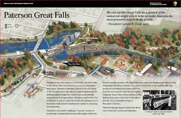
Park at the main parking lot on McBride Avenue, proceed along McBride Avenue to the path leading to the bridge above the Great Falls, here you will find rock examples of a variety of geology which make up this amazing waterfall. Note: There is an alternative parking lot on Maple Avenue as well.
 Aerial view of the Great Falls
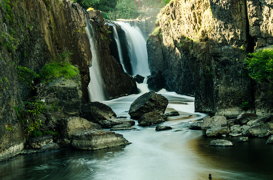
The Great Falls of the Passaic River is a prominent waterfall, and is one of the largest waterfalls in the United States, measuring about 77 feet (23 meters) high and 280 feet (85 meters) wide. Every day, 2 billion gallons (more than 7.5 billion liters) of water pour over the falls making it the most powerful falls in the eastern U.S.A. second only to Niagara Falls. The Great Falls thunders over a rocky ledge, 70 feet deep, about 60 feet wide to a broad basin descending 20 feet through traprock and sandstone to the City of Paterson.
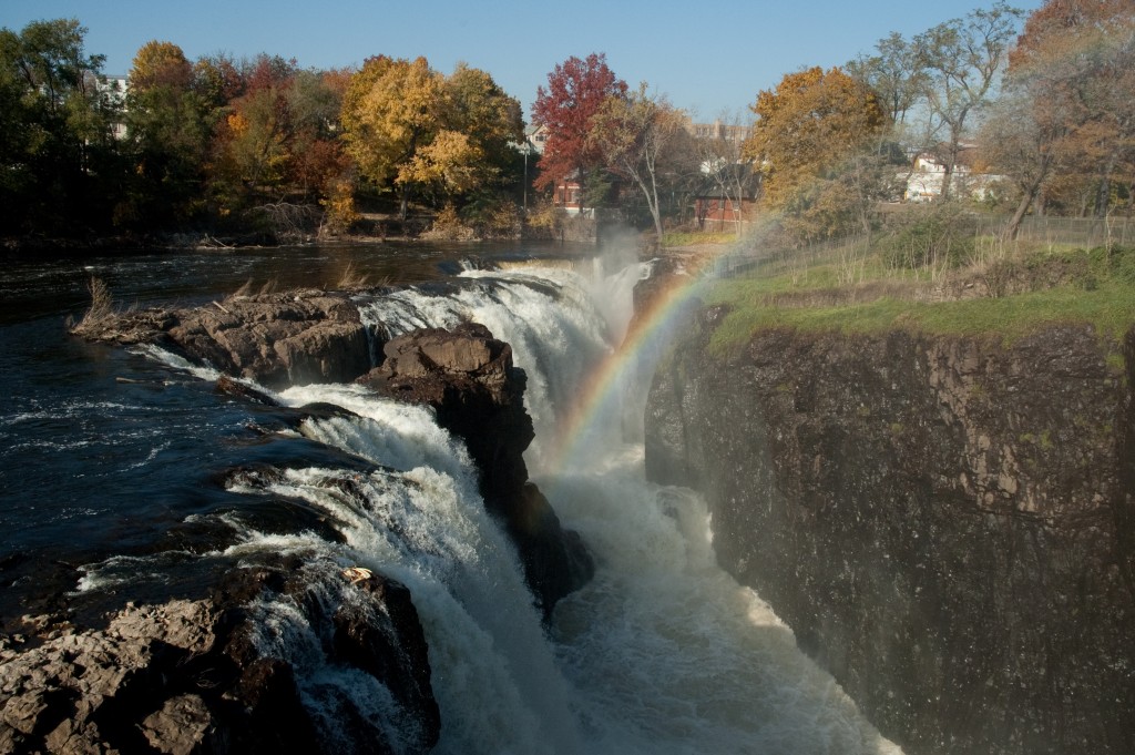 The Great Falls of the Passaic River
As one of the United States most powerful waterfalls, it played a significant role in the industrial development of New Jersey starting in the earliest days of the nation. It is part of the Great Falls of Paterson-Garret Mountain National Natural Landmark. It has also been designated as a National Historic Landmark District since 1976. The Great Falls' raceway and power systems were designated an Historic Civil Engineering Landmark in 1977.
The Great Falls of the Passaic River, with the surrounding historic mill area are protected as part of the Paterson Great Falls National Historical Park, it was designated on November 7, 2011, as America’s 45th National Historical Park, and the 397th unit of the National Park System. The Great Falls also played a key role in American history as the centerpiece of the first planned industrial center in the U.S.A.
 The Great falls National Park
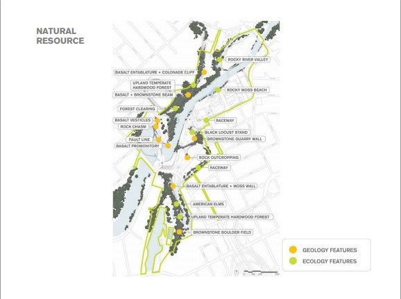 Natural Resources around the Great Falls
The Geography and Geology of the Great Falls
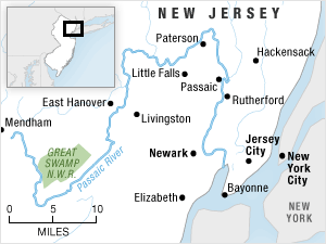
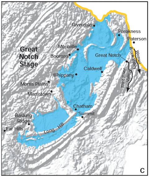
The falls are located near the northernmost point of the circuitous Passaic River, which flows for 80 miles (129 kilometers). The Passaic River headwaters start in Mendham in southern Morris County, travels through a varied landscape of marshlands, forests, suburbs, and industrialized urban areas to the Newark Bay.
 Passaic River
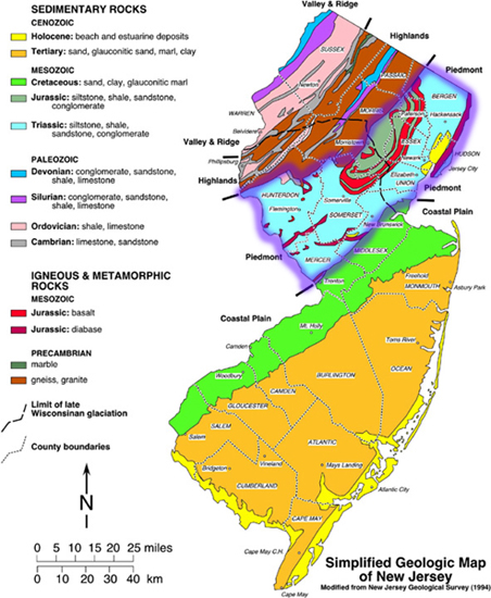
Geologically, the Great falls, as well as the modern Passaic River itself, were formed at the end of the last ice age approximately 13,000 years ago. Ice blocked rivers and formed a large lake west of the Watchung Mountains, called Glacial Lake Passaic. As glacier ice melted and receded the river's course found a new circuitous route around the north end of the Watchung Mountains. It carved the spectacular falls resulting in a dramatic cascade that tumbles over a ridge of volcanic basalt into the gorge and valley below. The river's previous course was blocked by a newly formed moraine through the underlying basalt, which was formed approximately 200 million years ago, reveling Paterson as the lower gap that is now the great falls.<>/p>
 Lake Passaic receded to revel the lower gap at Paterson
 Winter at the Great Falls
 Geology of the Great falls
Geologically speaking, Paterson's past is varied and exciting. Volcanic lava flows, upheavals, even the break-up of the super continent Pangaea - are all part of this area's geologic pre-history. Geology of the Falls and other natural features in Paterson give us clues to parts of this story. As you view the Falls from Overlook Park, walk over them through Mary Ellen Kramer Park, or take a short walk through Upper Raceway Park, you'll see some of these clues.
When viewing the falls we see the results of the interplay between internal forces within the earth's crust and of the external forces of erosion and weathering. The internal forces are seen in the chasm as numerous cracks and joints in the rocks. These mostly vertical cracks are caused by underground pressure from millions of years ago. The large rectangular basalt are outlined in the cliffs, huge blocks of small fragments of the basalt have fallen from the cliffs and now lie in the water. This happened because of erosion and wearing away of rocks by natural agents such as falling and running water.
The falls spill over a resistant ridge into a chasm carved in the lower flow of the Orange Mountain Basalt where it overlies the upper contact of the Passaic Formation. In the vicinity of the falls, glacial erosion has stripped away the upper more friable pillow lavas. These pillow lavas can be seen in the abandoned traprock quarries throughout the hillsides in the Paterson area. Minerals occur in fractures and in gas pockets that formed within the pillows of lava as they cooled. Some of the hollow chambers in the rock were probably lava tubes that drained before the lava cooled.
 Valley of the Rocks Cliffs
The Great Falls and The Valley of the Rocks
The Valley of the Rocks is across and adjacent to the falls. The height of the cliff is 130 feet with several variety of typical lava rock, sandstones and shale which lava flowed. The general view of the cliff gives the opportunity to see columnar structure of basalt. Two kind or rocks can be seen here, reddish colored sandstone at the bottom and gray basalt (solidified lava) at the top.
Sandstone is a rock formed from sand. During the age of the dinosaurs there were streams flowing in the area carrying mud in the sand. When the velocity of the water decreased, both the mud and sand were deposit as sediments. Later the layers of sand were compressed and cemented to form Sandstone. The mud was compressed a form shale. One can see the layering in the sandstone, this is why sedimentary rocks are also called layered rock.
Shale is also exposed at the Valley of the Rocks is can be identified as thin layers and irregular masses in the sandstone. The contact surface between basalt, underlying sandstone and shale is clearly seen.
Erosion worked its way along the joints and cracks and caused large blocks of basalt to fall into the river from the cliffs. The chasm into which the water falls developed a huge crack widened by erosion.
Paterson Falls located in the Igneous & Metamorphic Rock area
 Basalt rocks at the Paterson falls
A. The nature of the basalt rock is massive here at the Paterson falls. The basalt comes in several varieties, in part depending upon whether it was formed from the lower part of the lava flow, which is massive, or the upper part of the lava flow where rock is often divided into columns.
B. Basalt rock is primarily dark gray in color, but in places it has yellowish brownish color as a result of chemical weathering, from changes of rocks as a result of moisture and temperature changes to exposure.
C. Chemical weathering, here one can see the brown color cause my iron hydroxides, formed by iron bearing minerals in the basalt, the rock literally rust. A white coating of calcium carbonate is seen in places where ground water seeped through cracks in the rock.
D. Plants taking hold on solid rock, lichen, moss, ferns, grass, and small trees grow in the crevices.
 Lava/basalt
To Log this EarthCache:
To get credit for this Earthcache you need to meet the logging requirements by answering the following questions. Please email me the answers before you post your log. There are a number of locations to view the falls.
1. From the parking lot and overlook near the statue of Alexander Hamilton, look across at the basalt outcrops of the cliffs. What features do you see there? Is there a difference in the texture of the upper rocks from the lower ones? Describe?
2. From the footbridge overlooking the falls, look to the right to a cliff face, that shows the contact of the basalt with the sandstone below it. Can you tell the difference between the sedimentary rocks below and the igneous rocks above? It may help to find a freshly broken surface. What do you see? Do you see the kind of alteration change of minerals or geologic texture (metamorphism)?
3. The beauty of the view depends heavily on recent weather. The falls flow mightily after heavy rain, but reduce lighter flow during dry periods. During your visit please note the Falls "Flow Rate" depending on the weather conditions of recent rainfall or dry periods up river it will determine the flow rate of heavy, moderate, light at the falls. Please estimate what is the flow rate over the Great Falls during your visit? Optional: see flow rates at USGS.org
4. There are many great places to take pictures of this natural earths beauty, take and post many photos of the Great Falls, with or without yourself in the photo (optional).
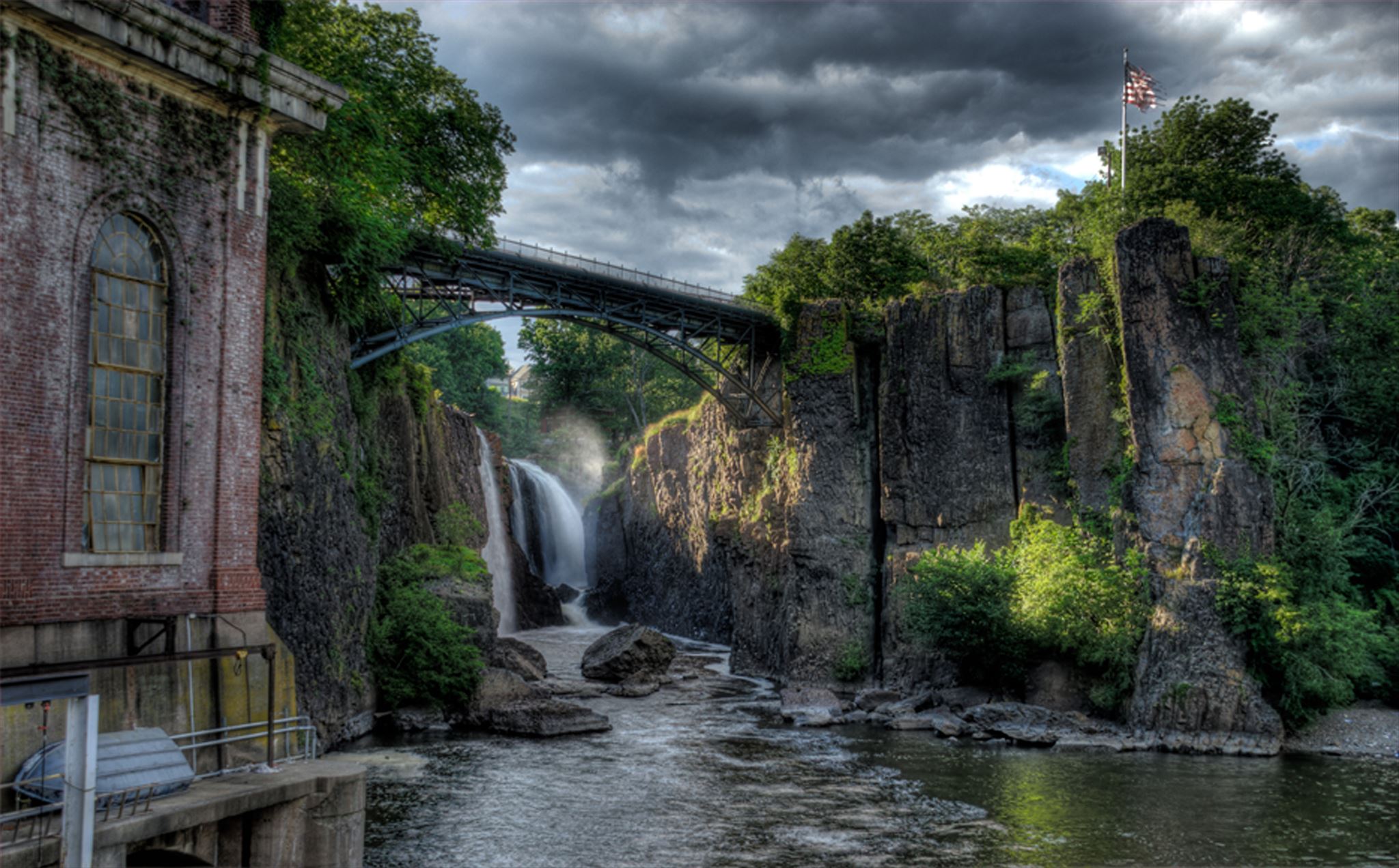
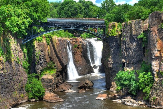 Bridge across the Great Falls
Early History / Acquackononk: The Lenape and the Dutch
Before European colonization, the area surrounding the Great Falls was the territory of the Acquackanonk tribe of Lenape Native Americans. They called the falls “Totowa,” meaning “to sink or be forced down beneath the waters.” Dutch traders and missionaries began visiting the area near the falls In the late 1670s. One visitor in 1680 described the falls as “a sight to be seen in order to observe the power and wonder of God.” By the end of the 17th century, knowledge of this natural wonder had become widespread, and the falls began to attract numerous visitors. Meanwhile, settlers were establishing farms in the area. In 1685 fourteen Dutch settlers received formal patents to the land in what came to be Acquackanonk Township. Over time, as the land was passed on to the settlers’ descendants in smaller parcels, the economy of the area became more diversified: some residents became weavers, carpenters, and stonemasons, or operated mills, distilleries, or stores. But the area remained rural and Dutch until the late 18th century
George Washington / Alexander Hamilton
On July 9, 1778 George Washington, Lafayette, Alexander Hamilton and aide-de-camp James McHenry picnicked by the Great Falls during the Revolutionary War. Shortly afterward, McHenry wrote a picturesque account of the event:
"After viewing these falls we seated ourselves round the General under a large spreading oak within view of the spray and in hearing of the noise. A fine cool spring bubbled out most charmingly from the bottom of the tree. The travelling canteens were immediately emptied and a modest repast spread before us, of cold ham, tongue and some biscuit. With the assistance of a little spirit we composed some excellent grog. Then we chatted away a very cheerful half hour - and then took our leave of the friendly oak."
Note: The historic meeting of Washington and Hamilton took place in Marry Ellen Kramer Park.
The Nation's first Industrial City development
In his visit with Washington in 1778, Alexander Hamilton was inspired by the power of the falls and realized that the Passaic River could be harnessed and used to power an industrial city. After the Revolutionary War Hamilton went on to become President Washington's and the nation's first Secretary of the Treasury. He selected the site of the nation's first planned industrial city, which he called a "national manufactory." Hamilton believed that the United States could be truly independent if it reduced its reliance on European manufacturing and developed its own domestic industry. On July 4, 1792, Paterson, America's first planned industrial city, was established, centered around the Great Falls of the Passaic River. Hamilton helped establish the Society for Establishing Useful Manufactures, which founded Paterson, which was named for New Jersey Governor William Paterson. From humble mills would rise industries that changed the face of the United States. The mills were powered by harnessing the power of the Passaic River. Water was diverted just above the falls and directed into channels called raceways.
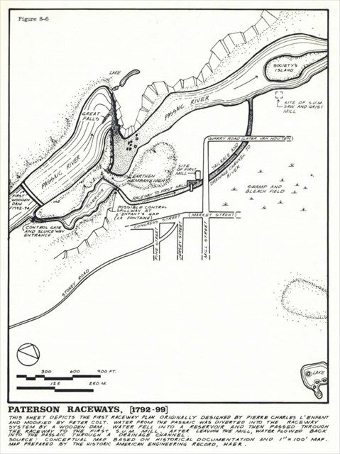 Industrial Raceways to harness the power
The potential power of the Great Falls of the Passaic River so inspired Alexander Hamilton that he organized and found the Society for Establishing Useful Manufactures, (S.U.M.), state-chartered private corporation to fulfill this vision and planned America's first industrial city. Hamilton commissioned civil engineer Pierre Charles L'Enfant, responsible for the layout of the new capital at Washington, D.C. to designed the raceway system. His plan called for a complex three-tired system, and factory owners would rent a "seat" along the raceway. The water rushed through the raceway at an average speed of 25 mph. The water would run over or under the factory's main waterwheel, which was connected to a main drive shaft. Belts connected smaller gears to the main shaft which were eventually connected to the machines that workers used to make a variety of products. These products included silk, ribbon, sails for ships, twine and locomotives. The city of Paterson became a thriving industrial center and help the new nation get "on its feet."
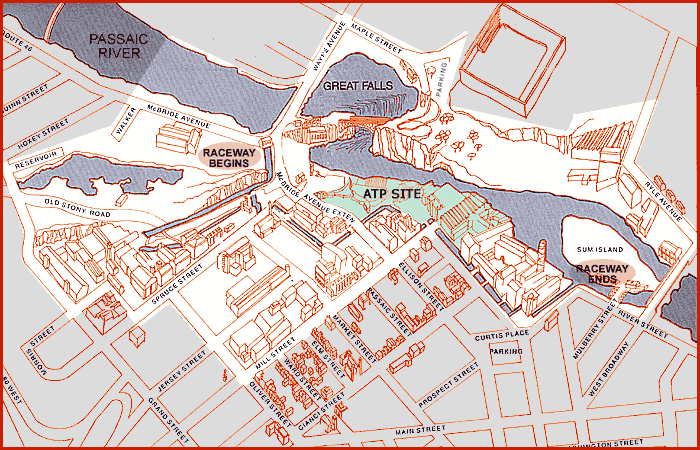 The Great Falls of the Passaic River Raceway
The Falls create the Paterson Industrial city
As a result, the Paterson became the nucleus for a burgeoning mill industry. In 1793, two years after the society's foundation, Paterson was the site of the first water-powered cotton spinning mill in New Jersey. In 1812, it was the site of the state's first continuous roll paper mill. Other products whose construction used the falls as a power source include the Rogers Locomotive Works (1832), the Colt revolver (1837), and the USS Holland, the first modern submarine, was tested just above the Great Falls (SS-1) (1898). The oldest extant structure in the historic district is the Phoenix Mill, built in 1813. The industrial area also became the site of labor unrest, as it was a center for the [1913 Paterson silk strike]. Immigrant workers, facing harsh conditions in factories staged numerous strikes, giving the United States its first organized labor movement.
Samuel Colt was an early Paterson business owner from 1836 until 1842, his gun mill produced about 5,000 guns. A lack of government contracts was a major factor in his failure in Paterson. He later achieved success in his hometown of Hartford, Conn., with the outbreak of the Mexican-American War. A new National Park in Connecticut was founded in 2014 called Coltsville National Historical Park, which talks about his later successes. You can view Paterson Colts at the Paterson Museum at 2 Market Street, a short walk from Overlook Park.
The Great Falls of Paterson ~ today ~ A National Historical Park.
A section of the Paterson Great Falls National Historical Park (Mary Ellen Kramer Park) reopened on August 15 after significant improvements were made to the falls observation area. The new park has undergone about $1.8 million in work, including new paved walking paths, lighting, benches, landscaping and the rebuilding of a wall that will allow visitors to get closer to the waterfall. The new park was dedicated August 28th, 2015 as the Mary Ellen Kramer Park, remains owned by the city, officials plan to transfer ownership to the National Park Service. Meanwhile, city, county and federal officials are moving ahead on a separate improvement plan for Overlook Park, on the south side of the river near the Falls.
Paterson Great Falls National Historical Park was authorized to be added to the National Park System of the United States under the Omnibus Public Land Management Act. On March 30, 2009, President Obama signed legislation authorizing the falls as a national historical park, which would provide additional federal protections for the 77-foot waterfall. By 2011, Great Falls State Park and other land along the Passaic River were transferred to the federal government for the creation of the park. Formal establishment as a unit of the National Park System required action by the Secretary of the Interior, which took place November 7, 2011, when Secretary Salazar formally accepted lands on behalf of the United States, and dedicated the park as the nation's 397th park system unit.
The Northern New Jersey Cachers, NNJC is about promoting a quality caching experience in Northern New Jersey. For information on The Northern New Jersey Cachers group you can visit: www.nnjc.org.
 NNJC.ORG