Please note - there is NO guaranteed cell phone reception at this cache site. Know the requirements for this earthcache before arriving.
Important things to know to avoid log deletion:
- if your answers will be sent at a later time, state when I will receive them in your found log.
- required photo must be personalized in some way so that I know you were truly there.
If I delete your found log due to lack of following instructions, you can re-log your find when you are able to comply.
Mount Rainier National Park is open all year. There is an entrance fee, good for 7 days, for each vehicle entering the park unless you have a special pass such as an annual pass or a Golden Eagle Pass. Information about these passes can be obtained at the entry points to the park. Please park only in designated parking spots and do not leave the trails/sidewalks during your explorations.
If you are unable to access the stated coordinates, please don't log a find. If the main trail is closed, know that there is a second, less traveled trail on the opposite side of the canyon.
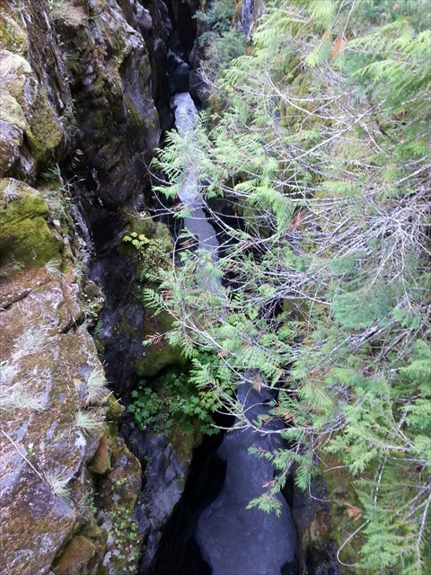
From the north bridge at Box Canyon
Box Canyon is an enigma. It is unusual to have such a narrow, deep, and steep walled canyon (or gorge) in a glaciated area. More typical at Mount Rainier are U-shaped, glacially carved canyons such as Stevens Canyon.
To log this cache - Read each of the three sections, observe as requested at the stated coordinates, and answer the question at the end of each section based on presented information and your observations. Your responses are expected to be thoughtful and complete, based on the stated locations and written text.
There are three given locations at the stated coordinates and waypoints 1 and 2. There are three tasks and questions to answer while visiting the three locations.
Task 1: Some state that Box Canyon is, geographically, a box canyon - a canyon with steep walls on three sides allowing access only through the mouth of the canyon. Others state that it is slot canyon - a canyon that is significantly deeper than wide, formed by the wear of water rushing through rock.
What to do: Visit the three given locations. At the two bridges, look down into the canyon on the north side of each to see the Muddy Fork of the Cowlitz River directly below you. At the viewpoint near waypoint 2, observe the panoramic view of the canyon and river.
Question 1: After visiting the three given locations tell whether you would call this a slot canyon or a box canyon and give reasons for your answer.
Task 2: There are differing opinions related to the formation and history of Box Canyon, which cuts through a ridge of old lava known as Ohanapecosh rock. One thought is that a rift was formed as a result of cooling of the volcanic rocks. Another is that the rift was caused by earthquakes. Some say that the rift was at one time filled with an intrusive dike of softer material which was eroded away over time by the force of the water flow.
What to do: At the north bridge (stated coordinates) stand on the north side of bridge and look down. Observe the canyon carefully (a strong light may help if it is a dark day) and take a few minutes to be amazed while thinking about which way you think the canyon was formed.
Question 2: At the north bridge, the stated coordinates, note the difference between the upper and lower portions of the wall, compare the difference and tell how you think each section (upper and lower) was formed and what you saw that leads you to that conclusion. A flashlight may help on a dark day.
Task 3: One thing about which there is common agreement is that as you walk between the three sets of coordinates, is that you are walking over glaciated terrain. The rocks here were polished by the Cowlitz glacier about 10,000 years ago.
What to do: As you walk along the paved trail between the two bridges, and then especially near waypoint 2, look for evidence that the glacier once covered this area.
Question 3: After your walk to the 3 locations, and while at waypoint 2, give two things you have seen that are evidences that a glacier receded from this area. You are standing on two examples at waypoint 2.
Requirement: A personalized photo of you at the north bridge (the stated coordinates.) If camera shy, use a badge or your name on a piece of paper and include that in your photo at the site.
Sources include Mount Rainier rangers and Geology Underfoot in Western Washington by Dave Tucker