Descobrir o CORVO/Knowing CORVO

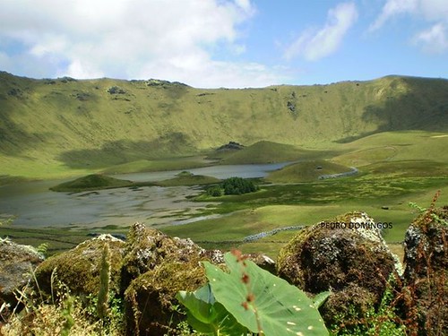
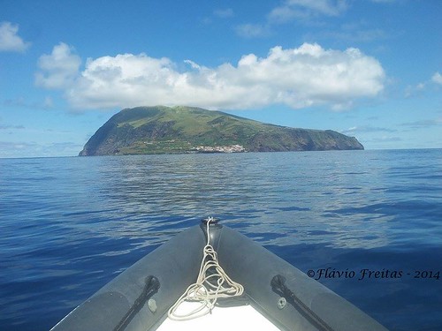
A ilha do Corvo é a menor das ilhas do Arquipélago dos Açores, localizando-se no Grupo Ocidental, sobre a Placa Norte-Americana, a norte da Ilha das Flores. A ela corresponde territorialmente o município de Vila do Corvo, o único dos concelhos da República Portuguesa que não tem qualquer freguesia. A ilha ocupa uma superfície total de 17,2 km², com 6,5 km de comprimento por 4 km de largura. É formada por uma única montanha vulcânica extinta - o Monte Gordo, coroado com uma ampla cratera de abatimento chamada localmente de Caldeirão, com 3,7 km de perímetro e 300 metros de profundidade e onde se aloja a Lagoa do Caldeirão. Nela se podem observar várias lagoas, turfeiras e pequenas 'ilhotas', duas compridas e cinco redondas. O ponto mais alto da ilha é o Morro dos Homens no rebordo sul do Caldeirão, com 718 metros de altura acima do nível médio do mar. Além desta elevação destacam-se ainda: a Lomba Redonda, a Coroa do Pico, o Morro da Fonte, o Espigãozinho e o Serrão Alto.
Na fase de exploração portuguesa do Atlântico sabe-se que foi Diogo de Teive quem achou as ilhas do Grupo Ocidental dos Açores, no regresso de sua segunda viagem de exploração à Terra Nova, em 1452. Terá sido descoberta em simultâneo com a Ilha das Flores, já que as ilhas se avistam mutuamente. A sua designação henriquina é Ilha de Santa Iria, mas foi também chamada de Ilhéu das Flores, ilha da Estátua, ilha do Farol, ilha de São Tomás e ainda de Ilha do Marco, tendo este nome persistido durante alguns séculos em razão, de para alguns servir o monte do Caldeirão servir como uma referência geográfica para os marinheiros ou, e mais provavelmente, pelo facto de existir um pequeno promontório a que foi dado o nome de Ponta do Marco, local onde possivelmente terá sido afixado algum padrão como era hábito fazer-se nas novas terras descobertas.
A Vila do Corvo, também chamada erradamente de Vila Nova do Corvo, é a mais pequena dos Açores, com 430 habitantes (em 2011). A única povoação da ilha é constituída por um aglomerado de casas baixas com ruas estreitas e tortuosas que sobem as encostas, conhecidas localmente por canadas. Sofreu devido à emigração, principalmente para os EUA e Canadá. A superfície do seu concelho corresponde a toda a superfície da ilha. O concelho mais próximo é Santa Cruz das Flores, tornando este o local habitado mais isolado de Portugal.
CACHE:
A cache não se encontra nas coordenadas indicadas. Para descobrir as coordenadas tem de decifrar o enigma. As repostas estão todas no texto. Siga os passos abaixo mencionados.
N 39° A0.(B+102)
W031° 0(C-0,5).(D+103)
A------------------Largura da ilha
B------------------Profundida do Caldeirão
C------------------Comprimento da ilha
D------------------Altura do ponto mais alto da ilha
PS: Não tem nenhuma conta de multiplicação ou divisão. Tenha cuidado com a cache. Não coloque fotos que revelem o lugar da cache. Tenha cuidado com os muggles.Traga material de escrita.

Corvo Island is the smallest of the Azores Archipelago, being located in the Western Group, on the North American Plate, north of Flores Island. The territorially it matches the municipality of Vila do Corvo, the only municipalities of the Portuguese Republic that has no parish. The island occupies a total area of 17.2 km², with 6.5 km long by 4 km wide. It is composed of a single extinct volcanic mountain - Monte Gordo, crowned with a large crater called abatement locally Caldeirão, with 3.7 km of perimeter and 300 meters deep and where it houses the Lagoa do Caldeirão. It can be observed several ponds, bogs and small 'islands', two long-five round. The highest point of the island is Morro dos Homens of the south rim of Caldeirão, with 718 meters of height above mean sea level. In addition to this elevation stand out even: the Lomba Redonda, the Coroa do Pico, Morro da Fonte, the Espigãozinho and Serrão Alto.
The Portuguese exploration phase of the Atlantic know that was Diogo de Teive who found the islands of the Western Group of the Azores on his return from his second voyage of exploration to Newfoundland in 1452. Was discovered simultaneously with the Flores Island since the islands mutually spot. Its designation is Henriquina island of Santa Iria, but was also called islet Flores Island statue, island lighthouse, island of St. Thomas and also of Marco Island, and this name persisted for several centuries because of to some serve the Caldeirão of the hill to serve as a geographical reference for sailors or, more probably, because there is a small promontory that was given the Marco Ponta name, where you may need some standard been posted as it used to If the newly discovered lands.
The Vila do Corvo, also erroneously called Vila Nova do Corvo is the smallest of the Azores, with 430 inhabitants (in 2011). The only village on the island consists of a cluster of low buildings with narrow, winding streets that climb the slopes, locally known as canadas. It suffered due to emigration, mainly to the US and Canada. The surface of the municipality corresponds to its whole surface of the island. The nearest county is Santa Cruz das Flores, making this the most isolated inhabited place in Portugal.
CACHE:
The cache is not at the given coordinates. To find the coordinates have to solve the riddle. The answers are all in the text. Follow the below mentioned steps.
N 39° A0.(B+102)
W031° 0(C-0,5).(D+103)
A ------------------ Island Width
B ------------------ Caldeirão Depth
C ------------------ Island Length
D ------------------ Height of the highest point of the island
PS: No multiplication or division account. Be careful with the cache. Do not load photos that reveal the place of cache. Beware of muggles.Bring a pen or pencil.