[JP]
フォッサマグナは、日本の主要な地溝帯の一つで、地質学においては東北日本と西南日本の境目とされる地帯です。語源はラテン語のFossa Magnaで、「大きな溝」を意味します(wikipedia. 以下同様)。
[EN]
Fossa Magna is one of the major rift valleys in Japan and geologically considered as the boundary between the north-east Japan and the south-west Japan. "Fossa Magna" is Latin and means a "great rift".(Wikipedia)
[JP]
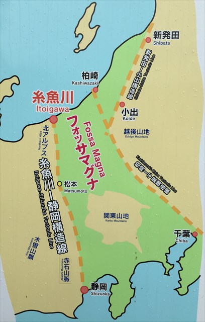
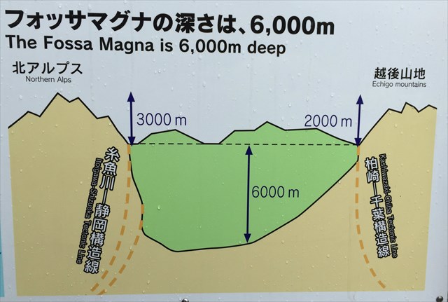
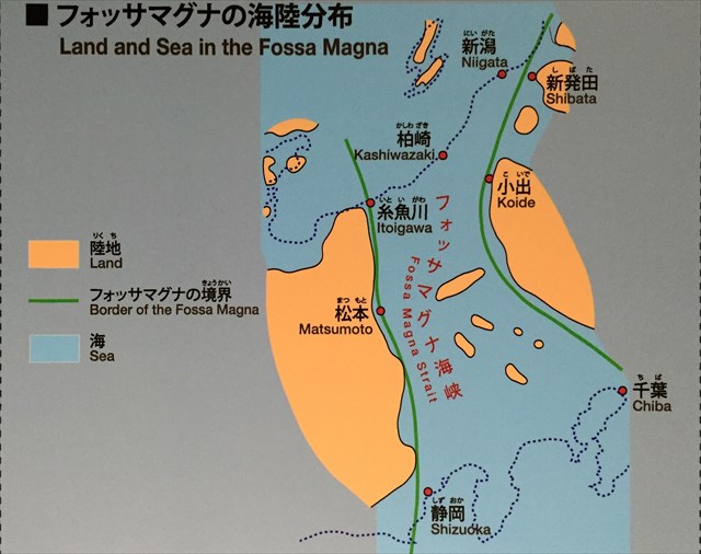
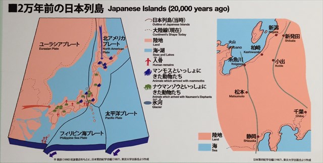
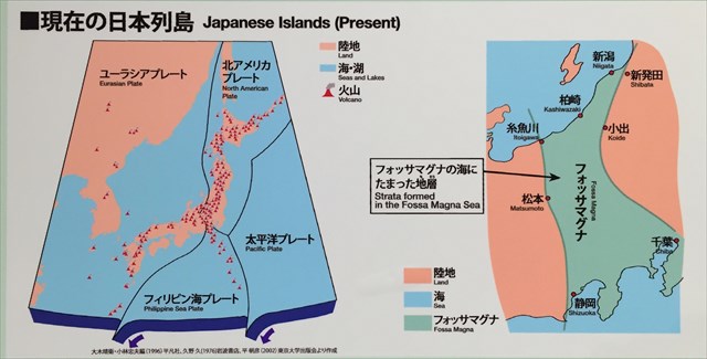
フォッサマグナは、本州中央部、中部地方から関東地方にかけての地域を縦断し、西縁は糸魚川静岡構造線(糸静線)、東縁は新発田小出構造線及び柏崎千葉構造線とされますが、東縁については異説もあります。フォッサマグナはしばしば糸静線と同一視されるますが、糸静線はフォッサマグナの西端であって、「フォッサマグナ=糸静線」とするのは誤りです。つまり、地図上においては、糸静線は「線」であるが、フォッサマグナは「面」です。端的に言えば、古い地層でできた本州の中央をU字型の溝が南北に走り、その溝に新しい地層が溜まっている地域がフォッサマグナです(下図)。 下の2つの図のうち上の図は平面図、下の図は東西方向の断面図です。
図中、黄色の部分(破線の西側及び東側の領域)は2億6000万年以上前に形成された暗緑色の変斑レイ岩、緑色の部分(破線に挟まれた部分)は約1600年前に形成された安山岩であり、形成された時期が大きく異なる岩石が隣り合っています。
[EN]
Fossa Magna longitudinally traverses the Japanese Island between the east Japan and the west Japan. Its west boundary is Itoigawa-Shizuoka tectonic line (hereafter, Ito-Shizu line), and its east boundary is Shinhotta-Koide tectonic line and Kashiwazaki-Chiba tectonic line. However, there is another theory for the east boundary. It is often considered that Fossa Magna equals to Ito-Shizu line, but that is wrong. Ito-Shizu line is just the west boundary of Fossa Magna. That is, on the map, Ito-Shizu line is a "line", while Fossa Magna is a "plane". Fossa Magna is the area where the U-shaped rift formed of the old strata is running in the north-south orientation, which rift is filled with the new strata (see figures below). The upper figure is the plane view, and the lower figure the cross section in the east-west orientation.
In the figures, the yellow areas (the west side of the left dash line and the east side of the right dash line) are epigabbro formed about 260 million years ago, and the green area between the dash lines is andesite formed about 16 million years ago. That means that two rocks formed in very different eras are adjacent with each other.
フォッサマグナの構造はどのように形成されたのか?/How has Fossa Magna been formed?
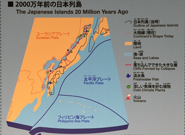
[JP]
日本列島の形成プロセスを追いながら、フォッサマグナの構造がどのように形成されたのかを見てみましょう。
[EN]
Let's see how the structure of Fossa Magna has been formed by following the formation process of Japanese Islands.
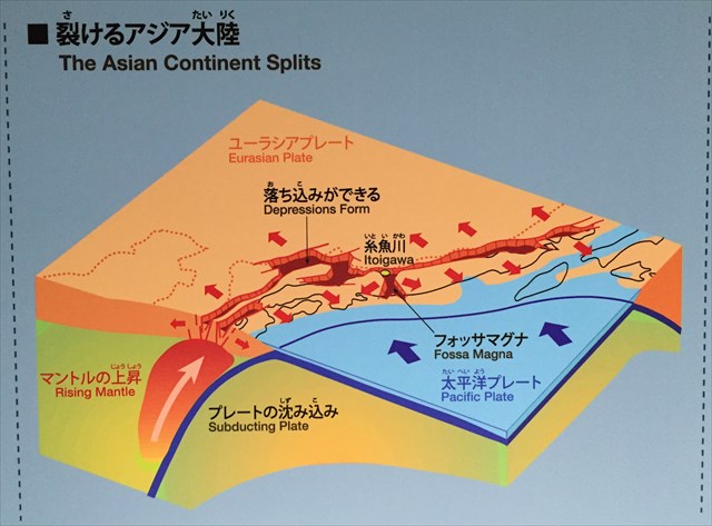
2000万年前「裂けるアジア大陸」/20 million year ago"The Asian continent splits"
[JP]
太平洋プレートがユーラシアプレートの下に沈み込み、マントルからの熱い上昇流によって火山活動が起こり、アジア大陸が裂けはじめて、後に日本海とフォッサマグナになる落ち込みが誕生しました。後に日本海の落ち込みは、やがて湖になりました。日本海がかつて湖だった証拠として、淡水魚や昆虫の化石が見つかります。
[EN]
As volcanic eruptions began in the Earth's mantle, a fissure opened on the Asian continent and depressions formed which would later become the Sea of Japan and the Fossa Magna. The Sea of Japan depression became a lake, as evidenced by freshwater fish and insect fossils found from this period.
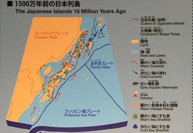
1500万年前「拡がる」/15 million year ago"Widening"
[JP]
湖はさらに拡がって日本海になりました。日本海には多くの海底火山ができました。フォッサマグナの落ち込みには海が浸入して「フォッサマグナ海峡」ができました。フォッサマグナが海になった証拠として、ニシンやスズキなどの海の魚の化石が見つかります。
[EN]
The lake began to widen until it met the ocean and the Sea of Japan was born. Many underwater volcanoes formed in the Sea of Japan at this time. The sea also rushed in to fill the Fossa Magna depression, forming the Fossa Manga Strait. Fossils of sea fish, like herring and sea bass are evidence of this sea in the Fossa Magna.
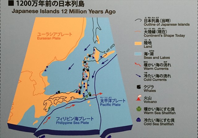
1200万年前「埋まる」/12 million year ago"Filling"
[JP]
フォッサマグナ海峡は、砂岩泥岩互層によって埋め立てられていきました。砂岩泥岩互層は、大地震によって起こった海底地すべりによってできた地層です。
[EN]
Alternating layers of sandstone and mudstone eventually filled the Fossa Manga Strait. Alternating sandstone and mudstone strata were formed by underwater landslides caused by massive earthquakes.
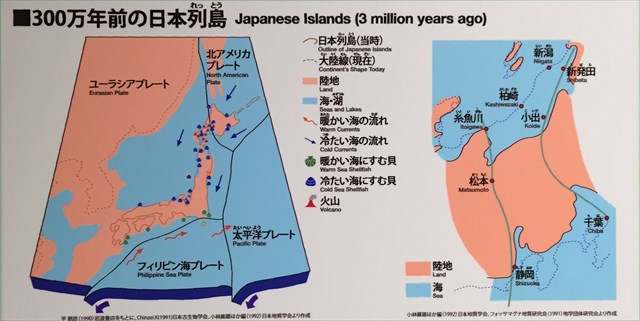
隆起する日本列島/Lifting Japanese Islands
[JP]
その後、日本列島は次第に隆起をはじめ、フォッサマグナは海から陸へと変わっていきました(以下の3つの連続図参照)。大地は、山地や丘陵・盆地・平野などに分かれていきました。山地や丘陵は、地震を起こしながら隆起し、火山が誕生して日本列島は地震と火山の国になりました。
[EN]
After that, Japanese Islands began to lift gradually, Fossa Magna changed from the sea to the land(see the three successive figures below). The land fell into mountains, hills, basins and plain fields. Mountains and hills lifted with causing earthquakes, and volcanoes were born. Thus Japanese Islands has had a lot of earthquakes and volcanoes.
タスク/Task for claiming your Found log
[JP]
このEarthcacheのFound logを送信する前に、以下の2つのクイズの回答をキャッシュオーナーにメッセージしてください。
[EN]
Before claiming your Found log, please send your answers to two quizzes below.
Quiz 1
[JP]
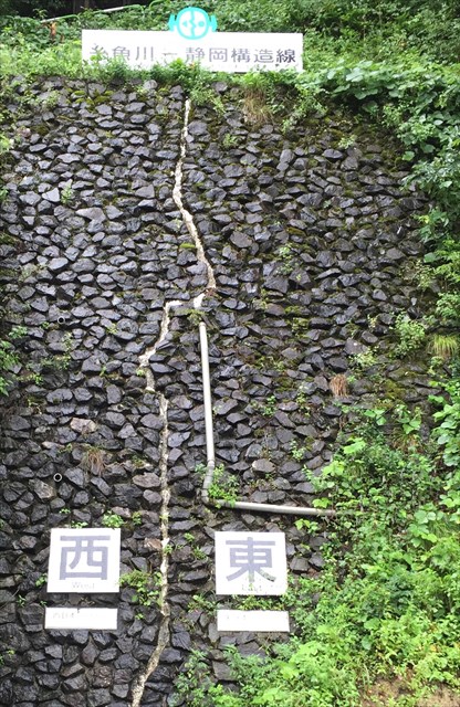
公開座標では、糸静線の露頭を観察することができます。下写真中央の白い破線が糸静線の位置を示しますが、両側は補強用の石垣であって露頭そのものではありません。露頭自体は、写真手前において観察することができます。
西側の変はんれい岩と東側の安山岩との間の断層帯には、断層の運動に起因してしょうじた変化が観察されます。どのような変化が観察されますか?
[EN]
At the published coords, you can observe the exposure of Ito-Shizu line. The white dash line in the middle of the picture below indicates the position of Ito-Shizu line. The stone wall is not the exposure itself, but for reinforcement. You can observe the exposure itself near side of the picture.
You can observe transformation in the fault zone between epigabbro on the west and andesite on the east due to movement of the fault. What transformation is observed?
Quiz 2
[JP]
Additional waypoint 1及び2において、かつて海底火山が存在した証拠を観察することができます。それは何でしょうか?
[EN]
At the Additional waypoints 1 and2, you can observe an evidence that there used to exist underwater volcanoes. What is it?