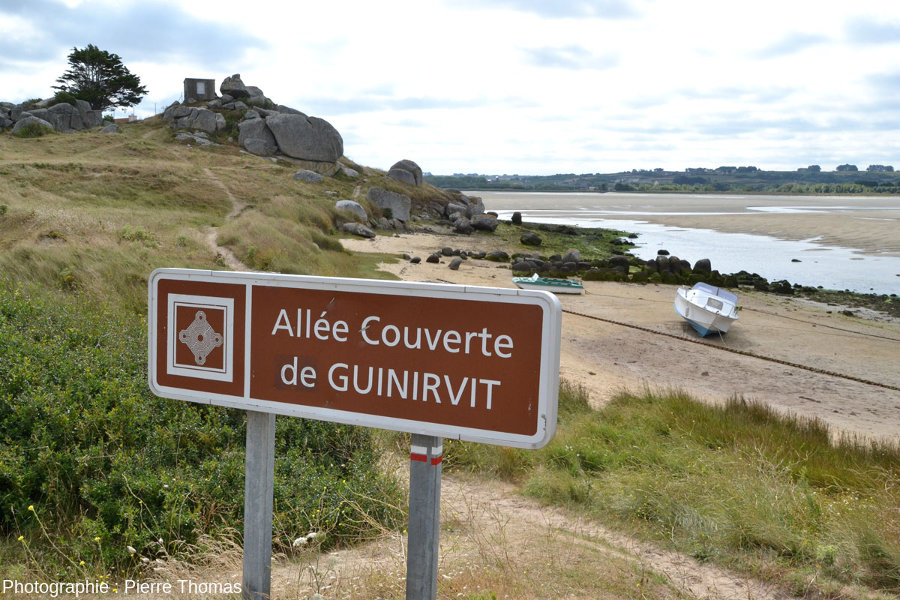
Ce sont des sortes de dolmens précédés d'une allée de pierre et parfois entourés d'une couronne de pierres dressées .
Celle de Guinirvit est particulièrement ruinée, et, en particulier, a perdu ses dalles horizontales faisant office de plafond.
Elle daterait, comme toutes ses homologues, du début de l'âge du bronze (-2 500 a avant notre ère).
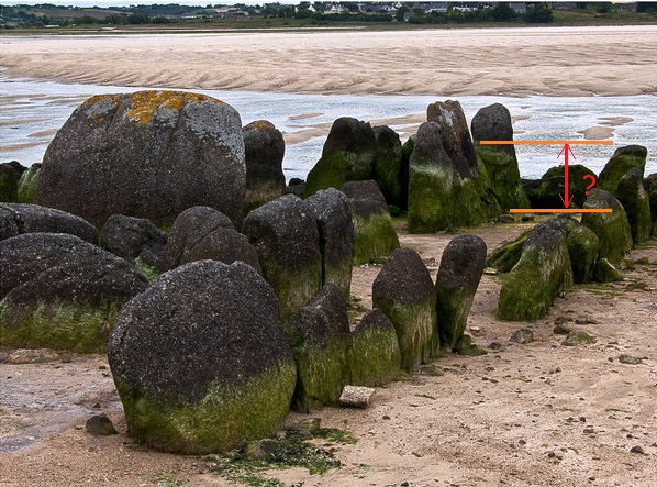
Ce qui fait son originalité, c'est qu'elle est entièrement située sur l'estran.
Découverte à marée basse, elle est entièrement immergée lors des grandes marées.
English version:
These are kinds of dolmens preceded by an alley of stone and sometimes surrounded by a ring of standing stones.
Guinirvit is particularly ruined, and, in particular, lost its horizontal slabs acting as a ceiling.
It dates back, like all its counterparts, the beginning of the Bronze Age (2500 BC has).
What makes it unique is that it is entirely located on the foreshore.
Exposed at low tide, it is entirely submerged during high tides.

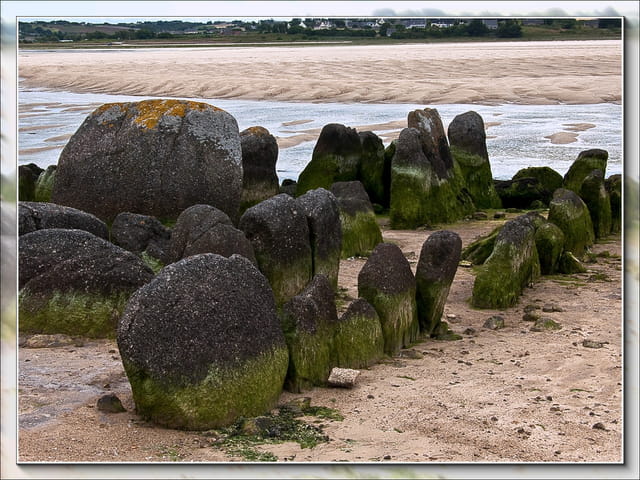
Comme les bâtisseurs de l'âge du bronze n'ont certainement pas bâti cette allée dans la zone de balancement des marées,
cela signifie que la mer est montée ou que cette zone de la Bretagne s'est enfoncée de quelques mètres depuis 4 500 ans.
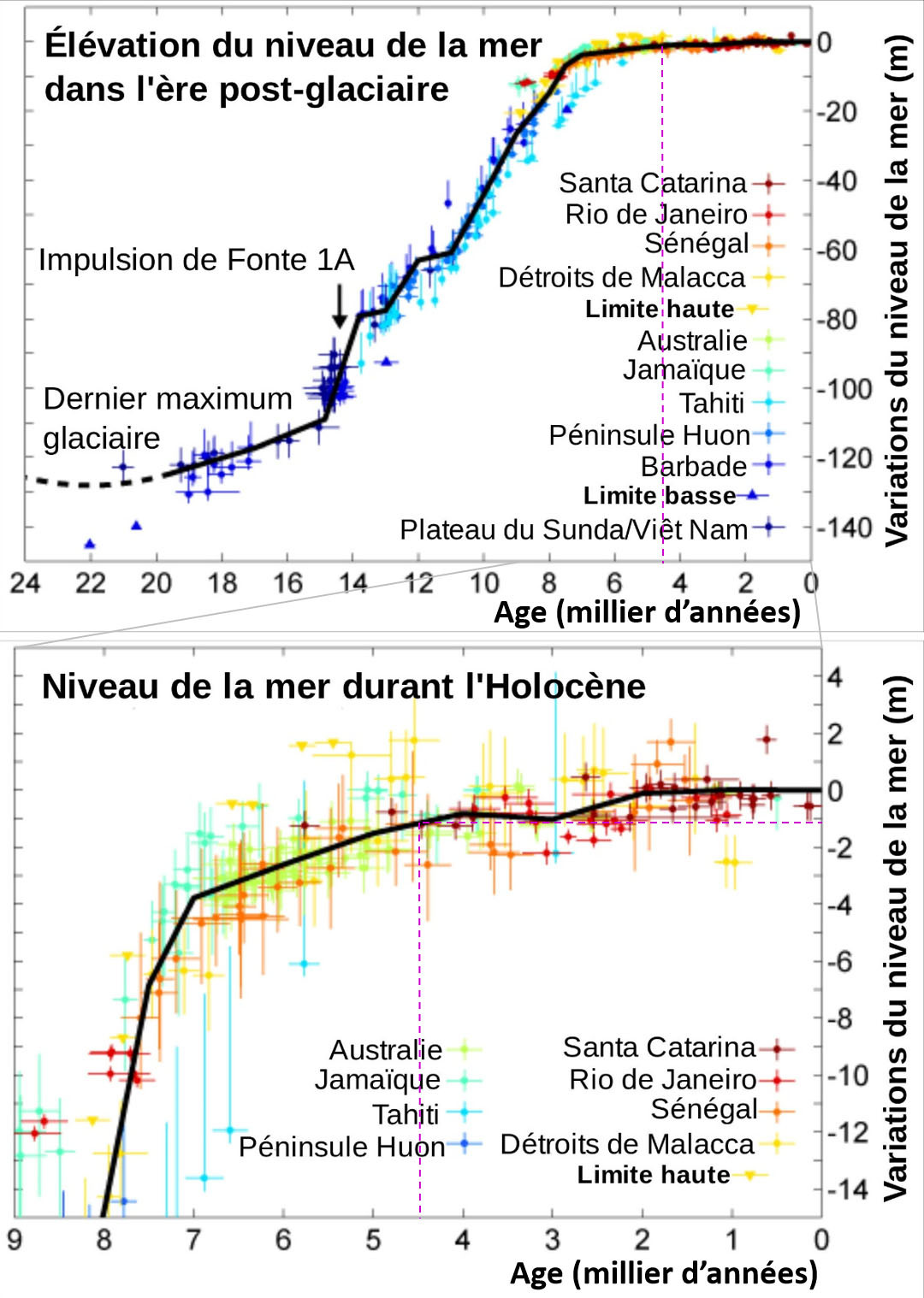
D'après tous les archéologues, il y a 4 500 ans, on était à la fin de la période qu'on appelle l'« optimum climatique de l'Holocène »,
entre -8 000 et -4 000 ans.
As the builders of the Bronze Age were certainly not built this alley in the intertidal zone,
it means that the sea is rising and that this area of Brittany sank a few meters since 4500 years .
According to all the archaeologists, there are 4500 years old, it was at the end of the period called the "Holocene climate optimum",
between 8000 and 4000 years.
Pendant cette période, le Sahara était vert, la température moyenne de l'hémisphère Nord était légèrement supérieure à la moyenne actuelle,
et le niveau de la mer un peu plus haut que le niveau actuel.
During this period, the Sahara was green, the average temperature of the Northern Hemisphere was slightly higher than the current average,
and sea level a little higher than the current level.
Depuis 4 500 ans, date de la construction de l'allée couverte de Guinirvit, le niveau de la mer a tendance à baisser globalement
(en négligeant la remontée récente due au réchauffement climatique actuel).
Ce n'est donc pas une remontée de la mer qui est responsable de la submersion de l'allée couverte de Guinirvit,
mais bien un enfoncement de ce secteur de la côte bretonne.
Since 4500 years, when the building of the grave of Guinirvit the sea level tends to decline globally
(neglecting the recent rise due to the current climatic warming).
This is not a rise in the sea which is responsible for the flooding of the grave of Guinirvit but a depression of this sector of the Brittany coast.
Crédit photos : Pierre Thomas, OT Plouescat, Kentynet sur wikipedia, CC BY-SA 3.0
Pour valider cette earthcache, répondez aux questions suivantes :
- Comment nomme-t-on, en géologie, une zone qui s'enfonce ?
- Comment nomme-t-on, en géologie, une zone qui s'élève ?
- Comment s'appelle la couronne de pierres dressées entourant l'allée couverte ?
- Mesurer sur le rocher, la hauteur corespondant au trait rouge de la photo du rocher.
- Sur place, de quoi cette hauteur est-elle un témoin ? expliquez...
To validate this earthcache, answer the following questions:
- How is called, in geology, an area that is sinking?
- How is called, in geology, an area that rises?
- How is called the ring of standing stones surrounding the covered walkway?
- Measure on the rock, the length corespondant the red line of the picture of the rock.
- On site, what is this height a witness? explain ...
Une visite de ce site pourrait vous aider : Planet Terre, Eduscol :
A visit to this site could help you :
Bonnes recherches !
Attention à la marée ! http://maree.frbateaux.net/73
Loguez cette cache "Found it" et envoyez-moi vos propositions de réponses
soit via mon profil, (eureka 29 )
soit via la messagerie geocaching.com (Message Center), et je vous contacterai en cas de problème.
Une photo de vous ou de votre GPS sur place sera la bienvenue, mais n'est pas obligatoire
Log this cache without waiting for our confirmation,
but you must send us the answers by e-mail at the same time via our profile (eureka 29 ).
Or by geocaching.com (Message Center),
If there is a problem with your answers we will notify you.
A picture of yourself or your GPS on site would be welcome but is not mandatory.
Rappel concernant les « Earthcaches »: Il n'y a pas de conteneur à rechercher ni de logbook à renseigner.
Il suffit de se rendre sur les lieux, de répondre aux questions ci-dessus et de nous renvoyer les réponses.