Smoky Hills physiographic region:

The Smoky Hills region is part of the Plains Border sub region of the Great Plains. It occupies nearly all of north-central Kansas, bordered on the west by the High Plains, on the northeast by the Dissected Till Plains, on the east by the Flint Hills, and on the south by the Arkansas River lowlands. The region extends into south-central Nebraska, bordered on the north by the Rainwater Basin. It consists of three belts of hills, all running southwest to northeast, which correspond to the underlying geological formations. The Smoky Hills proper comprise the easternmost belt; the two western belts are known as the Blue Hills. The hills of the westernmost belt are also known as the Chalk Bluffs. The Blue Hills escarpment forms the boundary with the High Plains to the west. The Environmental Protection Agency divides the region into two ecoregions, the Smoky Hills proper constituting one in the east and the Blue Hills and Chalk Bluffs constituting the other, the Rolling Plains and Breaks ecoregion, in the west.
The region is divided into three regions based on the underlying rock outcroppings: The Dakota Formation (sandstone), the Greenhorn Limestone and the Niobrara Chalk.
The Dakota Formation forms the eastern region. This area includes the Smoky Hill buttes, which are capped by sandstone and provide a sharp contrast with the surrounding plains. One of the most notable buttes is Coronado Heights in Saline County. There are concretions at Rock City in Ottawa County and Mushroom Rock State Park in Ellsworth County. These are cemented by calcium carbonate.
The Greenhorn Limestone region in the central region is made up of thin—usually less than 6 inches (15 cm)—chalky limestone beds alternating with thicker beds of grayish shale. This area is known as post rock country due to the practice of early settlers using limestone for buildings and fenceposts since trees were scarce.
The chalk beds of the Niobrara Chalk are exposed in bluffs of the western Solomon, Saline, and Smoky Hill Rivers and in an irregular belt in the west. This area includes such Kansas landmarks as Castle Rock and Monument Rocks in Gove County. The chalk beds are known for the late 19th and early 20th century excavations of exceptionally well-preserved fossils of marine reptiles such as the plesiosaurs and mosasaurs found in the uppermost member of the Niobrara Chalk, the Smoky Hill Chalk.
Natural arch
A natural arch comes to be when erosion finds a weakness within the rock wall and penetrates and exploits that weakness. Over time all that’s left is an arch or bridge.
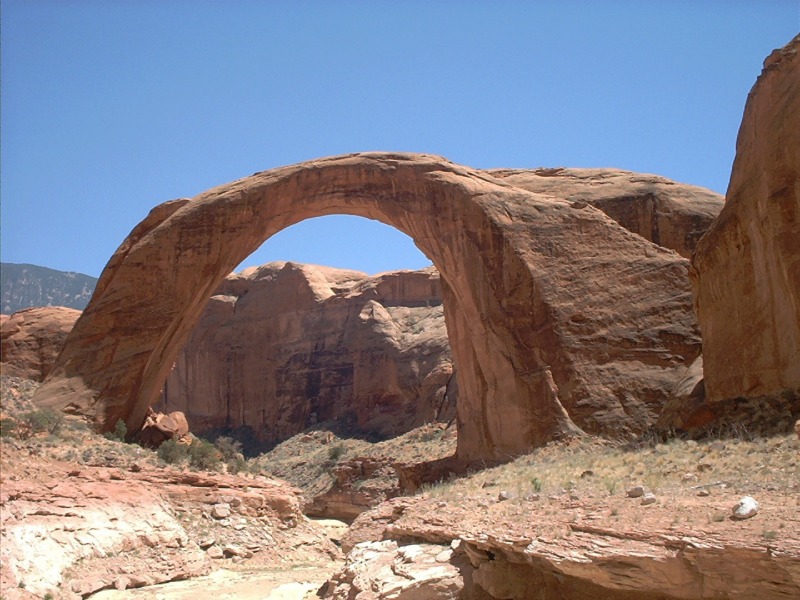
Rainbow arch in Utah
Erosion
Erosion is the process by which soil and rock are removed from the Earth's surface by natural processes such as wind or water flow, and then transported and deposited in other locations.
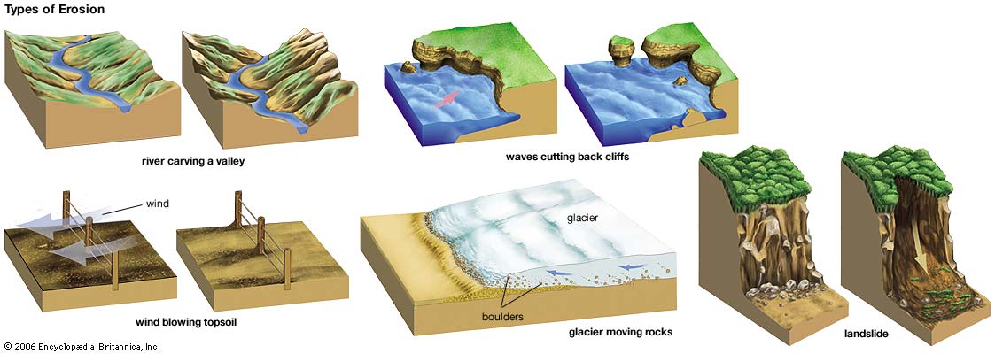
Types of Erosion:
Splash Erosion: Small soil particles are detached and sent airborne through the impact of raindrops on soil.
Sheet Erosion: Raindrops break apart the soil structure and it's moved down-slope by water that flows overland as a sheet rather than definitive channels. This occurs frequently during cloud bursts.
Rill Erosion: This process develops small, short-lived, concentrated flow paths. These paths create a sediment source and delivery system for hill-slope erosion. Areas where precipitation rates exceed soil infiltration rates are more prone to this type of erosion.
Gully Erosion: Water flows in narrow channels during or directly following heavy rains or melting snow. The gullies can erode to considerable depths.
Valley or Stream Erosion: Continual water flow alongside land (along a linear feature) creates this type of erosion. It extends downward, deepening a valley, and head-ward, extending the valley into the hillside. This occurs most frequently in times of flooding.
Bank Erosion: Over time, banks of rivers and streams are naturally worn down.
Freezing and thawing: Cold weather causes water trapped in tiny rock cracks to freeze and expand, breaking the rock into several pieces.
Wind erosion is a major geomorphological force, especially in arid and semi-arid regions. Wind erosion is of two primary varieties: deflation, where the wind picks up and carries away loose particles; and abrasion, where surfaces are worn down as they are struck by airborne particles carried by wind.
Mass movement is the downward and outward movement of rock and sediments on a sloped surface, mainly due to the force of gravity. Mass movement is an important part of the erosional process, and is often the first stage in the breakdown and transport of weathered materials in mountainous areas. It moves material from higher elevations to lower elevations where other eroding agents such as streams and glaciers can then pick up the material and move it to even lower elevations. Mass-movement processes are always occurring continuously on all slopes; some mass-movement processes act very slowly; others occur very suddenly, often with disastrous results.
Source: (water)
**Logging requirements**
DO NOT POST ANSWERS IN YOUR LOG.
Send the following answers to me via email.
- The text "GC61RD2 Smoky Hills Arch" on the first line
- What is the specific name given to this rock here?
- How wide is the arch?
- How tall is the arch?
- What type of erosion caused this erosion?
Sources
- Victor R., Baker. Britannica, 2013. 0.
- Rader, A.. N.p.. Web. 4 Sep 2013..
- water: erosion. Art. Britannica Online for Kids. Web. 4 Sept. 2013.
- Kansas Geological Survey
- Kansas Department of Transportation
| I have earned GSA's highest level: |
   |