Arequipa the white city offers a mild and sunny climate all the year, supported by the Pacific Ocean which is only 75 km away. Arequipa is surrounded by 3 volcanoes: the cone shaped Misti, 5822 meters high, the Chachani reaching up to 6076 meters and the Picchu Picchu a bit more far away. This town is absolutely worth seeing and you should take enough time for sightseeing.
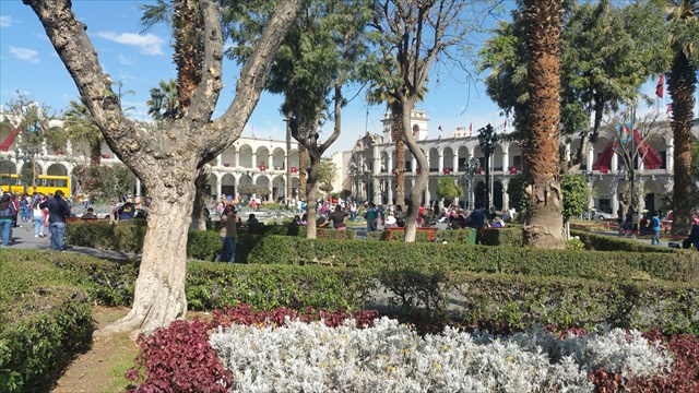
The white city Arequipa
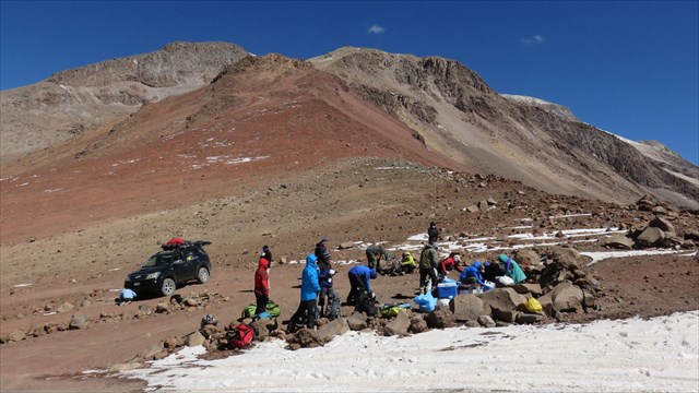
The absolute highlight is the ascent of the Chachani (6.076 m) from Arequipa. This mountain hike is a serious operation, particularly because of this height. You need definitely a professional phase of acclimatization and you have to be a professional in use of crampons and ice pick. These are mandatory preconditions for the climb up. The suggested north face ascent (about 1.000 meters heigth difference) needs to be started very early (around 2 am) and takes between 6 to 8 hours. An alternative could be the ascent through the eastern face which is a bit shorter, but was not possible at my time of visit because of too much snow. My description is just a suggestion which needs to be checked against the actual local conditions. The ascent is anyway an enterprise of your own risk and responsibility.
End of the dirt road
To log the cache you have to climb up to the very peak of Chachani and you have to provide answers to the following questions:
1. Call up at least three different type of volcanoes and nominate at least one exampl for each of them.
2. To which type of volcano Chachani belongs to?
3. When have been the last eruption of Chachani?
4. Provide the exact coordinates of the peak point (crosses), plus/minus 25 m tolerance accepted.
5. The climbers of the Chachani very often use a geological particularity for their descent from the summit through the north face of the mountain. This particularity is a distinct characteristic of this slope. It shortens the time of descent significantly related to the walk down on the regular way to the top of Chachani. Please describe this geological particularity: what is it, specify details of its structure, nature, origin, size and color.
Optionally I would be glad if you provide a photo of you/your GPS at the summit. Please send your answers to my email adress of my geocache profile. Subject should be 'Nevado Chachani' and your geocache nickname. You are allowed to log instantly. If your answers are incorrect, I will come back to you. Logs without email will be cancelled by no comments.
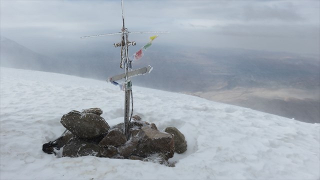
Top of Chachani
Español
Los volcanes de Perú son en su mayoría estratovolcanes, es decir, que se componen de capas individuales de lava y masas sueltas y son reconocidos por su forma de cono empinado.
Todos los volcanes fueron creadas a finales del Cuaternario terciario o tener carácter y de alta montaña. La actividad volcánica se debe al proceso fundamental de la tectónica de placas de Nazcaplatte bajo una de las más grandes placas continentales, la placa de América del Sur.
En la región de Arequipa, entre Orcapampa y Andagua, ubicado cono volcánico cerca de 80 más pequeño del Valle de los Volcanes son menores de 3.000 años.
Arequipa, la Ciudad Blanca tiene, durante todo el año , un clima suave y soleado, favorecido por el Océano Pacífico, que está a sólo 75 kilometros en línea recta. Está rodeado por 3 volcanes: el 5.822 m de altura cónica Misti, Chachani el alto 6076 metros y la más pequeña y más remota Picchu Picchu. Para esta ciudad , que sin duda debe tomar tiempo, es absolutamente digno de ver!
Un punto a destacar es el ascenso de Chachanis, 6076 m, de Arequipa. Esta caminata es un reto de gran altura debido a la altitud. Una aclimatación profesional y manejo seguro de crampones y piolets son necesarios para el ascenso de este volcán . Para el ascenso propuesto norte ( aproximadamente 1.000 metros ), consulta waypoints, la cual está programada para comenzar en la noche, se espera de 6 a 8 horas. Otra posibilidad es la ruta del este (unos 600 metros), pero el tiempo de mi ascensión no fue posible debido a la cantidad de nieve. Por lo tanto , la Nota : la ruta es una propuesta que el ascenso del volcán bajo su propio riesgo y la acción.
Para registrar el caché, sin embargo, el ascenso cumbre y responder a las preguntas es un requisito previo:
1. Nombrar al menos 3 tipos de volcanes, cada uno con un ejemplo que!
2. ¿Para qué tipo de Chachani oído?
3. Irrupción Cuando fue la última de Chachanis?
4. Exposición en el punto más alto ( la cruz, se puede ver en el listado ) las coordenadas , una tolerancia de más / menos 25 m se acepta!
5. Los escaladores de Chachani utilizan durante el descenso en el flanco norte de la Montar una característica geológica que es especialmente pronunciado en este Son lado, y este descenso hacia el descenso en la Ruta de ascenso acorta significativamente. Describir esta característica geológica : lo que es, la llamada Detalles de la estructura, la naturaleza, el origen, el tamaño y el color.
Opcional Yo sería feliz con una foto contigo / GPS de la cumbre! Enviar un correo electrónico con las respuestas correctas ( Asunto: Nevado Chachani y tu Apodo en geocaching.com ) de la dirección de correo electrónico en mi perfil GC. Usted puede inscribirse inmediatamente si hay alguna discrepancia con las respuestas, me levanto. Registros sin correo de respuesta se borrarán de mi!
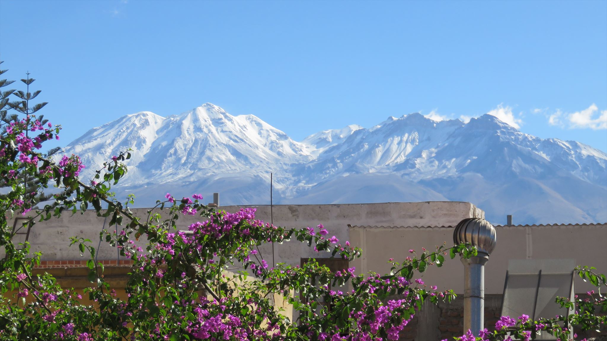
Chachani view from Arequipa
Deutsch
Die Vulkane Perus sind mehrheitlich Stratovulkane, d.h. sie sind aus einzelnen Schichten von Lava und Lockermassen aufgebaut und man erkennt sie an ihrer steilen und spitzkegeligen Form.
Alle Vulkane sind im späten Tertiär oder im Quartär entstanden und haben Hochgebirgscharakter. Der Vulkanismus ist auf den fundamentalen Prozess der Plattentektonik der Nazcaplatte unter einer der größten Kontinentalplatten, der Südamerikanischen Platte, zurückzuführen.
In der Region Arequipa, zwischen Orcapampa und Andagua, befinden sich ca. 80 kleinere Vulkankegel des Valle de los Volcanes, die jünger als 3.000 Jahre sind.
Arequipa, die weiße Stadt, hat das ganze Jahr über ein mildes und sonniges Klima, begünstigt durch den Pazifik, der nur 75 km Luftlinie entfernt ist. Sie ist umgeben von 3 Vulkanen: den 5822 m hohen kegelförmigen Misti, den 6076 m hohen Chachani und den kleineren und entfernteren Picchu Picchu. Für diese Stadt sollte man sich unbedingt Zeit nehmen, sie ist absolut sehenswert!
Ein Highlight ist die Besteigung des Chachanis, 6.076 m, von Arequipa. Diese Bergtour ist eine hochalpine Herausforderung aufgrund der Höhe. Eine professionelle Akklimatisationsphase und sicherer Umgang mit Steigeisen und Pickel sind Voraussetzungen für die Besteigung dieses Vulkans. Für den vorgeschlagenen nördlichen Aufstieg (ca. 1.000 Höhenmeter), siehe auch Wegpunkte, der nachts begonnen werden soll, rechnet man 6 bis 8 Stunden. Eine weitere Möglichkeit ist die östliche Route (ca. 600 Höhenmeter), die jedoch zum Zeitpunkt meines Aufstiegs wegen der Schneemenge nicht möglich war. Deshalb auch der Hinweis: die Route ist ein Vorschlag, die Besteigung des Vulkans erfolgt auf eigene Gefahr und Handeln.
Um den Cache zu loggen, ist jedoch die Gipfelbesteigung und die Beantwortung der Fragen Voraussetzung:
1. Nenne mindestens 3 Vulkantypen mit jeweils einem Beispiel dazu!
2. Zu welchem Typ gehört der Chachani?
3. Wann war die letzte Erruption des Chachanis?
4. Messe am höchsten Punkt (Kreuz, siehe auch Bild im Listing) die Koordinaten, eine Toleranz von plus/minus 25 m wird akzeptiert!
5. Die Besteiger des Chachani nutzen beim Abstieg über die Nordflanke des Berges eine geologische Besonderheit, die es speziell ausgeprägt auf dieser Seite gibt, und die diesen Abstieg gegenüber dem Abstieg auf der Anstiegsroute deutlich verkürzt. Beschreibe diese geologische Besonderheit: um was handelt es sich, nenne Details der Struktur, Beschaffenheit, Herkunft, Größe und Farbe.
Optional würde ich mich über ein Bild mit Dir/GPS vom Gipfel freuen! Schicke bitte eine Email mit den richtigen Antworten (Betreff: Nevado Chachani und Deinem Nickname bei geocaching.com) an die Email-Adresse in meinem GC-Profil. Du darfst sofort loggen, falls es Unstimmigkeiten mit den Antworten geben sollte, melde ich mich. Logs ohne Antwortmail werden von mir kommentarlos gelöscht!