


El Guadiana es el cuarto río más largo de la península Ibérica con 744 km y el cuarto más caudaloso, atraviesa España y Portugal. Desemboca en el océano Atlántico.
The Guadiana is the longest fourth river of the Iberian peninsula with 744 km and the mightiest quarter, it crosses Spain and Portugal. It ends in the Atlantic Ocean.
O Guadiana é o quarto maior rio da Península Ibérica com 744 km e o quarto maior rio, atravessa a Espanha e Portugal. Desagua no Oceano Atlântico.
En España, atraviesa tres comunidades autónomas (Castilla-La Mancha, Extremadura y Andalucía), a través de las provincias de Ciudad Real, Badajoz y Huelva. En Portugal, atraviesa las regiones de Alentejo y Algarve.
In Spain, it crosses three autonomous communities (Castilla-La Mancha, Extremadura y Andalucía), across the provinces of Ciudad Real, Badajoz and Huelva. In Portugal, it crosses Alentejo' and The Algarve.
Em Espanha, três regiões autónomas (Castilla - La Mancha, Extremadura e Andaluzia), que atravessa as províncias de Ciudad Real, Badajoz e Huelva. Em Portugal, flui através das regiões do Alentejo e Algarve.
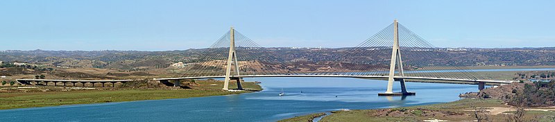
El río desemboca en el Golfo de Cádiz, entre Ayamonte (Huelva) y Vila Real de Santo António (Portugal), formando una zona de marismas (Marismas de Isla Cristina en España y la Reserva Natural do Sapal de Castro Marim e Vila Real de Santo António en Portugal). Es navegable en su curso bajo, en un tramo aproximado de 70 km.
The river ends in the Gulf of Cadiz, between Ayamonte (Huelva) and Saint's Vila Real António (Portugal), forming a zone of marshes (Isla Cristina's Marshes in Spain and the Natural Reservation do Sapal of Castro Marim and Saint's Vila Real António in Portugal). It is navigable on his low course, in an approximate section of 70 km.
O rio deságua no Golfo de Cádis, entre Ayamonte (Huelva) e Vila Real de Santo António (Portugal), formando uma área de zonas húmidas (marismas de Isla Cristina em Espanha e a reserva natural do Sapal de Castro Marim e Vila Real de Santo Antonio em Portugal). É navegável em seu baixo curso, em um esforço de 70 km.
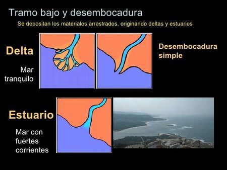
TIPOS DE DESEMBOCADURAS
Delta: Es una desembocadura en la que el río se divide en varios brazos y esto sucede porque en ella se acumulan los sedimentos que el río arrastra y forman islas.
Estuario: No se depositan sedimentos fluviales porque la fuerza de las mareas no lo permiten. Es una desembocadura en forma de embudo y en un solo brazo. Suele tener marismas a los lados.
TYPES OF RIVER MOUTHS
Delta: It is a river mouth in which the river divides in several arms and this happens because ithere are accumulated sediments that the river drags and form islands.
Estuary: It is a river mouth with funnel shape and in an alone arm. Fluvial sediments do not settle because the force of the tides do not allow it. It usually has marshes around it.
TIPOS DE BOCAS
Delta: É uma boca de rio, onde o rio está dividido em várias armas e isso acontece porque ele sedimentos que o rio se acumulam e forma ilhas.
Estuário: Rio sedimentos são depositados não porque não permitida pela força das marés. É um funil de boca em forma e em um braço. É tipicamente pântanos nas laterais.
Para registrar el earthcache, deberás enviar las respuestas a las siguientes preguntas por el centro de mensajes de geocaching (preferiblemente) o por email.
No subas ninguna respuesta con tu registro. Tampoco hace falta esperar a nuestra contestación para registrarlo. Si alguna respuesta está incorrecta nos pondremos en contacto con ustéd para solucionarla.
To log the earthcache, you will need to answer the following questions. Please submit your answers via the geocaching message center (preferred) or via email.
Do not post the answers to your log. You do not have to wait for the reply before you claim this, though if something is noticeably incorrect with your answers, we will reach out directly to resolve it.
Para registrar o earthcache, você precisará responder às seguintes perguntas. Por favor, envie suas respostas através do centro de mensagens geocaching (preferencial) ou via e-mail.
Não poste as respostas no seu log. Você não precisa esperar pela resposta antes de reivindicar isso, mas se algo estiver visivelmente incorreto em suas respostas, entraremos em contato diretamente para resolvê-lo.
1. ¿Qué tipo de desembocadura tiene el Guadiana?¿Porqué? / What type of river mouth has the Guadiana? Why? / Qual o tipo da foz do Guadiana? Porquê?
2. ¿Los lados de la desembocadura son arenosos, fangosos o ninguna de las dos opciones. Describe el paisaje? / The sides of the river mouth are sandy, muddy or none of two options? Please, describe the landscape./As margens da Foz do Rio são areia,lodo ou nenhuma das duas opções? Descreve a paisagem
3. ¿Puedes ver el fondo del río?¿Cuántos metros tiene aproximadamente en las coordendas iniciales? / Can you see the bottom of the river? how many meters is approximately at the coordinates?/Podes ver o fundo do Rio? Quantos metros é aproximadamente na coordenada inicial?
4. Sube una foto del lugar con tu log (opcional) / Upload a picture with your log (optional) / Se quiseres podes publicar uma foto do lugar.
THESE QUESTIONS HAVE BEEN TRANSLATED TO BY Filipona*
ESTAS PREGUNTAS HAN SIDO TRADUCIDAS AL PORTUGUES POR Filipona*
GRACIAS / THANKS