How to get there and some rules.
If you plan to visit paradise I suggest you join a charter, if you have the ability to come on a private boat please ensure your captain is aware of the Great Barrier Reef Marine Authority's Rules Click here You can kayak, use a boat of your own, hire a boat (around $100) for two hours, or join one of the tours that go out to the Island ($380+). Take water, a hat and appropriate clothes. Pack carefully and stay safe in the water. You will need sunscreen. Check the weather and the tides. Always wear a life jacket.
Low Isles was discovered by Captain Cook in 1770 and was described in his log as a ‘small low island’. The idyllic tropical island is situated approximately 8 nautical miles from Port Douglas and is home to not only spectacular coral gardens and marine life, but to a plethora of spectacular migratory bird life such as mangrove kingfishers, sea eagles and ospreys. Low Isles is approximately 4 acres in size, it is surrounded by 55 acres of coral reef, much of it close to the shore, making snorkelling a popular pastime. The sanctity of the blue lagoon creates a calm and protected snorkelling site with an abundance of marine life such as fusiliers, sweet-lip, angelfish and turtles. The lighthouse on Low Isles was built in 1878 and has long become a base for scientific research and weather data collection. Low and Woody Islands make up Low Isles and form a protected lagoon area in between the two islands. The Great Barrier Reef (GBR) is over 2300km in length and is over 18 million years old. It is the single most object of which can be viewed from space. A true phenomenon, the GBR is one of the most diverse and remarkable ecosystems in the world. The Great Barrier Reef was inscribed on the World Heritage list in October 1981.
If you look around you will notice a lot of Pumice laying around, even floating in the water. The majority of Pumice that you see today started arriving in July 2013 after an underwater volcanic explosion off the Kermadec Islands off New Zealand in Aug 2012. The 2012 Kermadec Islands eruption was a major undersea volcanic eruption that was produced by the previously little-known Havre Seamount near the L'Esperance and L'Havre Rocks in the Kermadec Islands of New Zealand.
The large volume of low density pumice produced by the eruption accumulated as a large area of floating pumice, a pumice raft, that was variously estimated to be between 19,000 and 26,000 km2. The eruption of the Havre Seamount was not initially noticed by scientists. Volcanologists were not even aware that the Havre Seamount was an active submarine volcano. After the pumice raft was detected, researchers retrospectively examined satellite imagery and past seismic activity in an attempt to pinpoint the time and location of the eruption that produced the pumice raft. Seismologists discovered a cluster of earthquakes (ranging in magnitude between 3.0 and 4.8) that occurred 18–19 July 2012.
These earthquakes were consistent with magma rising into a magma chamber prior to eruption. Analysis of satellite imagery showed an ash plume appear on 18 July 2012 and conclude several days later. Scientists were not aware that any eruption had occurred until a huge pumice raft was sighted and photographed at 14:40 NZST 0n 31 July 2012 by Maggie de Grauw while on a commercial flight from Faleolo, Samoa to Auckland, New Zealand. She emailed her pictures to Dr Scott Bryan, Senior Research Fellow at Queensland University of Technology. After discussion it was ascertained that the raft was around 1,000km north of Auckland. Dr Bryan then contacted Olivier Hyvernaud from the Laboratoire de Géophysique, Tahiti, who confirmed the location from Terra/MODIS imagery from NASA. The raft was subsequently sighted by members of the New Zealand Defence Force on 9 August 2012 several weeks after the eruption had occurred. The pumice raft measured approximately 480 km in length and more than 48 km in width, making the floating island larger in surface area than Israel.
Pumice is a type of extrusive volcanic rock, produced when lava with a very high content of water and gases, together these are called volatiles they are extruded (or thrown out of) a volcano. As the gas bubbles escape from the lava, it becomes frothy. When this lava cools and hardens, the result is a very light rock material filled with tiny bubbles of gas.
Pumice is the only rock that floats on water, although it will eventually become waterlogged and sink. It is usually light-colored, indicating that it is a volcanic rock high in silica content and low in iron and magnesium, a type usually classed as rhyolite. If the lava hardens quickly with few volatiles, the resulting rock is volcanic glass, or obsidian. Pumice and obsidian are often found together.
In commerce, pumice is the term applied to larger pumice stones, while pumicite consists of fine grains or ash. Pozzolan is a fine-grained pumicious material (both natural and man-made), which combines with lime to make a smooth, plaster-like cement. These three similar materials may be found and mined together, but they have different characteristics and different uses.
The name pumice is derived from the Latin word pumex, meaning foam. Pozzolan (or pozzolana) is an Italian word, named from Pozzuoli, the place near Naples where pozzolan was first mined and used as cement, during Roman times.
Since pumice is a volcanic rock, and retains its useful properties only when it is young and unaltered, pumice deposits are found in areas with young volcanic fields. Worldwide, over 50 countries produce pumice products. The largest producer is Italy, which dominates pozzolan production and also produces some pumice. Other major pumice producers are Greece, Chile, Spain, Turkey, and the United States. In the United States, Arizona, California, New Mexico and Oregon are the major producers of pumice, accounting for the majority of the nation’s pumice and pumicite production.
Pumice and pumicite are used to make lightweight construction materials such as concrete block and concrete. About three-quarters of pumice and pumicite is consumed annually for this purpose. The remainder of the pumice mined is used in abrasives, horticulture, landscaping, and for washing blue jeans. Pozzolan is used to make fine-grained, lightweight cement for finishing floors and building interiors.
To log this cache we require 1 x 1lt container, Pen/Texta and aprox 1lt fresh water to complete an experiment. You must also message us with the following answers to the best of your ability;
1 Examine a piece of Pumice, what colour is it and why is it this colour?
2 What size is it and what does this suggest to you about its journey here?
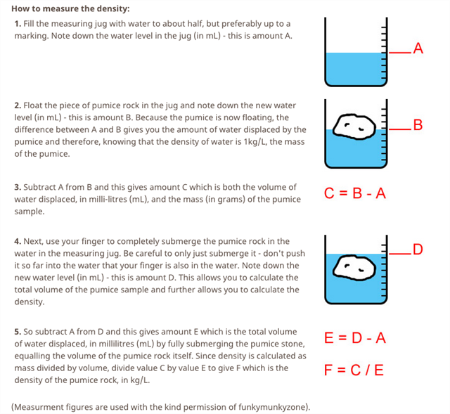
3 Using Fig. 1 work out the density of your piece of pumice. Please note you will need to use fresh water as salt water will alter the results.
4 A photo of your team or part of your team completing the experiment or at Low Isles, Please do this so we can live vicariously through you photos! (optional)
You are welcome to log your answers strait away to keep your TB's and Stats in order but please message us with your answers. Cacher’s who do not fulfil the Earth Cache requirement will have their logs deleted.
We hope you enjoy the GBR and Low Isles as much as we did, please tread lightly while in the area only leaving footprints and taking memories, we hope we taught you something. Happy Caching Cheers TeamThommo