Les réponses aux questions doivent être envoyées en même temps que votre log. Dans le cas contraire votre log sera supprimé sans avertissement.
The answers to the questions must be sent together with your log. Otherwise your log will be removed without warning.
La Tourbière du Plan de l’Eau
Français
Situation
La tourbière du Plan de l’Eau se situe à l’étage montagnard, sur un substrat constitué essentiellement des alluvions des torrents de Péclet et du Lou. Les variations altimétriques sont comprises entre 1760 et 1765 mètres. Le site couvre une surface de près de 3,4 ha. Le secteur occupe les 2 rives du torrent le "Doron". Ce replat constitue un bas-fond très humide favorable au développement de formations marécageuses de très grand intérêt écologique.
Le site est composé dune mosaïque d’habitats plus ou moins étroitement associés qui se regroupent en cinq grands ensembles: les habitats aquatiques (torrents et mares), les boisements, la végétation de ceinture de bord des eaux, les tourbières et marais, et les prairies qui bordent le site.
Le climat local est un climat de type montagnard avec un régime de précipitations témoignant de l’influence océanique. Ces conditions climatiques sont particulièrement favorables à la présence de zones humides.
Ce site a été classé Zone de protection de Biotope par Arrêté Préfectoral du 7 juillet 2003.
Qu’est-ce qu’une tourbière ?
Une tourbière est, par définition, une zone humide, colonisée par la végétation, dont les conditions écologiques particulières ont permis la formation d’un sol constitué d’un dépôt de tourbe.
Comment se forment les tourbières ?
La tourbe ne pouvant se former que dans des milieux constamment gorgés d’eau, une condition indispensable à la formation et au développement des tourbières est l’existence d’un bilan hydrique positif : les apports d’eau (pluie, neige, brouillard, ruissellement, nappe, etc) doivent être égaux ou supérieurs aux pertes (évapotranspiration, écoulements latéraux ou verticaux, etc.)
Différents facteurs interviennent dans l’établissement de ce bilan dont le climat, qui a un rôle fondamental:
- La pluviosité conditionne en grande partie les apports hydriques, alors que la température agit sur les taux d’évapotranspiration, en même temps qu’elle agit sur les mécanismes de production et de minéralisation de la matière organique.
- Les climats les plus favorables allient des précipitations importantes à des températures relativement basses.
Le rôle des tourbières
Les tourbières constituent des écosystèmes aussi riche que surprenants, car leur mode de fonctionnement est unique, tant du point de vue hydrologie que de la genèse du sol et des communautés vivantes qui y habitent.
A ce titre , les tourbières représente un véritable laboratoire à ciel ouvert et suscitent les plus grands intérêts en hydrologie, climatologie, archéologie, anthropologie et en biologie
Un intérêt climatologique : Savez-vous que la conservation des tourbières contribue à limiter les émissions de gaz à effet de serre ?
En effet, elles accumulent une quantité importante de carbone dans la tourbe, laquelle s’accumule sur plusieurs mètres de profondeur. Le carbone, ainsi fixé, ne circule plus dans l’atmosphère sous forme de CO2. Bien que ne représentant que 3 à 5 % de la surface de la planète, les tourbières stockent environ le tiers de tout le carbone contenu dans les sols de la planète
Les conditions locales peuvent également favoriser l’existence de tourbières. Ainsi, la topographie joue un rôle important, pouvant favoriser l’accumulation des eaux dans une dépression du sol, ou leur écoulement lent le long d’une faible déclivité offrent des conditions favorables à la génèse de milieux tourbeux. Bien entendu, le sol géologique est aussi à prendre en compte, déterminant la capacité à retenir les eaux et pouvant augmenter le bilan hydrique
Il existe différents types de tourbières :
- tourbière soligène
- tourbière topogène
- tourbière limnogène
- tourbière fluviogène
- tourbière ombotrophe
- tourbière ombrogène

Shéma : LES DIFFERENTS TYPES DE TOURBIERES
Comme il existe différents types de tourbe :
- tourbe bonde (ou tourbe fibrique) formée par des sphaignes, gorgée d’eau, de structure fibrique acide, riche en carbone organique
- tourbe brune : ou tourbe mésique
- tourbe noire (ou tourbe saprique) formée par des joncs et des laiches
Pour valider cette Earthcache, vous devez répondre aux questions ci-dessous :
Questions :
1. Le plan de l’eau est-il une zone favorable pour le développement d’une tourbière ? Pour quelles raisons ?
2. La topologie du plan de l’eau vous parait-elle offrir un espace propice à la formation d’une tourbière ? Pour quelles raisons ?
3. L’entretien des tourbières est-il intéressant pour la planète ? Pour quelle raison ?
4. En vous aidant des définitions et des schémas ci-dessus, pouvez-vous définir de quel type est la tourbière du plan de l’eau ? (soligène - topogène - limnogène - fluviogène - ombrotrophe - ombrogène) --> 2 réponses possibles
5. Aux coordonnées initiales, sur le panneau d’info, repérez la cartographie du Plan de l’Eau. Quel est le nom de la zone se trouvant de l’autre côté des zones de pêche ?
6. Quelle est la profondeur du "petit lac" en centimètres?
7. A compter du 24 octobre 2020 et conformément aux nouvelles règles de 2019 sur les earthcaches, une photo de vous ou d'un objet vous appartenant au point d'observation est obligatoire.
Comme pour toutes les géocaches de ce type, il n'y a pas de boite à trouver et pas de logbook à remplir. Une fois les réponses aux questions trouvées, vous pouvez enregistrer un log de type "trouvée" ou "found it". Dans le même temps vous devez m'envoyer les réponses, en français ou en anglais, via mon profil de Géocaching. Si vos réponses sont correctes, votre cache sera validée. Si jamais il y a un problèmes avec vos propositions, je vous contacterai. Merci de ne faire figurer aucune réponse dans votre log.
Attention : Cette cache peut ne pas être accessible à certaines périodes de l'année
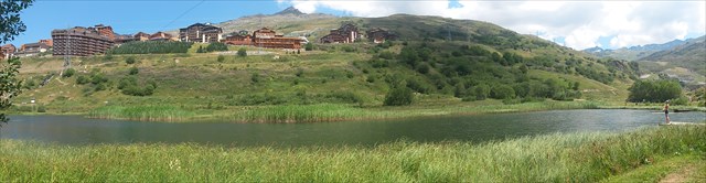
Panorama du Plan de l'Eau - Scenic view
English
Situation
The "Plan de l'Eau" is based a montain's level on a allluvial's substrate from Péclet and Lou. The elevation changes are between 1760 and 1765 meters. The site covers an area of nearly 3,4 ha. The area on the 2 banks of the river "Doron". This ledge is a very humid lowland favorable to the development of swamp formations offering a great ecological interest.
The site consists of a mosaic of more or less closely associated habitats that are grouped into five major categories: aquatic habitats (rivers and ponds), afforestation, the belt of vegetation waters edge, bogs and marshes, and grasslands that border the site.
The local climate is mountain's climate type with a rainfall regime reflecting the oceanic influence. These climatic conditions are particularly favorable to the presence of wetlands.
This site has been classified "biotope protection area" by a Prefectural decree of July 7, 2003.
What is a peatland ?
A peatland is, by definition, a wetland colonized by vegetation, the specific ecological conditions have allowed the formation of a floor made of a peat deposit.
How are peatlands?
Peat can not be formed only in permanently waterlogged areas, a prerequisite for the formation and development of peatlands is the existence of a positive water balance: water intake (rain, snow, fog, runoff, water, etc.) must be equal or greater than the losses (evapotranspiration, lateral or vertical flows, etc.)
Various factors are involved in the establishment of this review.
- The climate, in particular, has a key role:
o Rainfall largely determines the water intake, whereas the temperature acts on the evapotranspiration rates, at the same time it acts on the mechanisms of production and mineralization of organic matter.
o The most favorable climates combine precipitation at relatively low temperatures.
The role of peatlands
Peatlands are ecosystems rich and surprising because their mode of operation is unique, as the hydrological point of view of the genesis of soil and living communities that live there.
As such, peatlands represent a laboratory in the open air and arouse the greatest interest in hydrology, climatology, archeology, anthropology and biology
A climactic interest: Do you know that peatland conservation helps to limit emissions of greenhouse gases?
Indeed, they accumulate a significant amount of carbon in peat, which accumulates over several meters deep. Carbon, thus fixed is no longer flowing into the atmosphere as CO2. Although representing only 3-5% of the surface of the planet, peatlands store about a third of all carbon in soils of the planet
Local conditions can also promote the existence of peat bogs. Thus, topography plays an important role, can promote the accumulation of water in a depression in the ground, or slow flow along a gently sloping offer favorable conditions for the genesis of peatland. Of course, the geological soil is also taken into account, determining the capacity to hold water and that can increase the water balance
There are different types of peatlands:
- Soligene bog
- Topogene bog
- Limnogene bog
- Fluviogene bog
- Ombrotrophe bog
- Ombrogene bog
shema: TYPES OF PEATLANDS
Since there are different types of peat:
- Bung Peat (or fibric peat) formed by Sphagnum sip of water, fibric acid structure, rich in organic carbon
- Brown peat: peat or mesic
- Black peat (or saprique peat) formed by rushes and sedges
To validate this Earthcache, you must answer the following questions:
1. Explain why this place is a favorable area for the development of a peatlant? for what reasons ?
2. Why do you think that the topology of the "Plan de l'Eau" provides a space for the formation of a peatland? for what reasons ?
3. Why the maintenance of peatlands is good for the planet ? for what reason ?
4. Helping you with the definitions and diagrams above, can you define what type is the "Plan de l'Eau's peatland" ? (soligene - topogene - limnogene - fluviogene - ombrotrophe - ombrogene) -> 2 possible answers
5. At the initial coordinates, on the info's panel, locate the mapping of the "Plan de l'Eau". What is the name of the region located on the other side of fishing areas?
6. How deep is the "little lake" in centimeters ?
7. According with the new 2019 earthcache's rules and since October 24, 2020, a photo of you or an object belonging to you at the observation point is mandatory.
Take care ! This earthcache could be not reachable sometimes due to weather conditions !
As with all geocaches of this type, there is no box to find and no logbook to complete. Once you have found all the answers to the questions, you can record a log "found it". At the same time you have to send me the answers (in French or English), throught my Geocaching's profile. If your answers are correct, your cache will be validated. If there is a problem with your proposals, I will contact you. Thank you not to include any answers in your log.
Happy Geocaching !!