Village History
In recent times some prehistoric artefacts have been found in Tunstead, such as a Mesolithic flaked axe and two blade like flakes. However there are not enough finds to suggest an early settlement, even though a Roman road passed close by through Sloley.
Tunstead probably became a settlement in Anglo Saxon times, albeit a rather scattered one in clearings in the then extensive woodland. Its name derives from the Old English tun (meaning enclosure, settlement or farm) and stede (meaning place).
The Little Domesday Book of 1086 names the lord of the manor in the time of Edward the Confessor as one Alfer, a thegn of the last Saxon King Harold, who died at the Battle of Hastings. The manor, valued at £10 in 1066, but at £11 in 1086, was given to the Norman lord, Roger of Poitou (Poitiers). It seems he lost most of his lands by supporting Robert of Normandy, William the Conqueror’ son. He recovered most of them, but perhaps not Tunstead, because by Henry ll’s reign (1154 – 1189) the manor belonged to the de Grelley family.
In 1260 Thomas de Grelley was granted a weekly market: it was no longer operating by the seventeenth century, but is commemorated by Market Street.
The Tunstead and Happing House of Industry (the Workhouse) was erected in 1785 at Smallburgh. It appears to have had a large H-shaped main building with a number of other smaller ancillary buildings. Following a visit to Smallburgh, the commission's report noted that although the buildings could originally accommodate up to 800 inmates, the largest number of inmates was now 70 and a large part of the building was therefore shut up. The master had reported that able-bodied inmates were rare. The arrangements in the nursery well illustrated this, with baby in a cradle being tended by a deaf and dumb woman, and another infant in the arms of an imbecile. Sanitary arrangements were described as "non-existent" with commodes in the wards, and privies located outdoors some distance away. No running water water was laid on inside the house and thus no baths were taken. In 1924 the workhouse was closed and inmates were maintained at the Loddon and Clavering union workhouse at Heckingham.
The Tunstead and Happing workhouse was located at the east side of what is still known as Workhouse Road. The main workhouse building has been demolished. The surviving structures at the east of the site have now been adapated for residential and agricultural use.
The Tunstead Incorporation was one of the workhouses to issue its own coinage in the form of workhouse tokens in the early 1800s when there was a national shortage of copper coins. The tokens could be spent locally to buy bread and other basic commodities.
The Village Sign
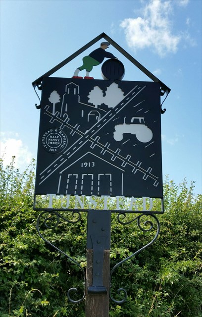
The new sign, which stands on the corner of Market Street and Ashmanaugh Road in Tunstead, uses design ideas from local school children to depict recognisable aspects of the village.
The original sign was created in 1965 by Harry Carter who was an art and woodwork teacher at Hamond’s Grammar School in the 1960s and whose craftsmanship helped create numerous village signs around East Anglia.It was gifted to the village by the Tunstead branch of the Women’s Institute to celebrate their 50th anniversary.
Over the years the old sign began to show signs of decay so in 2012 children at Tunstead Primary School were set the challenge of designing new village sign showing something associated with Tunstead.”
Using a selection of ideas from the children an overall design was created which was made into a new sign by a graphic designer and a metal worker.The finished sign is divided into four sections, which show St Mary’s Church, the primary school, a tractor ploughing a field and a token 1p from Tunstead Workhouse.The Tunstead Barrel Man shown at the top of the original sign has also been kept and is placed at the top of the new sign. The figure plays on the old English word ‘tun’ – meaning a barrel and a pot-bellied man.
You are looking for custom container. There is only room for a log so please bring your own pen. Tweezers may be useful.
It's possible to park on the verge in Belaugh Lane opposite the sign.
**************************************
If anybody would like to expand this series please do. I would just ask that you let SmokeyPugs know first so they can keep track of the Village Sign numbers and names to avoid duplication..
*************************************