Chalk bedrock is very porous. Rain falling onto chalk uplands percolates quickly into the ground to become groundwater. The groundwater filters through the chalk re-emerging in the valley as springs and diffuse seepages into the base of chalk streams. The chalk acts as a reservoir regulating the amount of water supplied to its streams. This gives chalk streams a stable flow regimes, that varies only slightly over time or during exceptionally dry or wet periods. Most chalk streams have a base flow index of 95%, that is the proportion of flow derived from groundwater, rather than directly from rainfall run-off. The temperature of the emerging groundwater as it enters a stream is very stable and rarely deviates from 10 to 12 °C. On cold winter mornings, it can look as though steam is rising above the relatively warm river.
Chalk, being mostly calcium carbonate, is a soluble rock and is slowly dissolved by rain, which is naturally slightly acidic. The process of chemical weathering of chalk results in very little sediment being generated, as the chalk is dissolved in rainwater and transported in solution in the stream flow. Unlike most rivers, chalk streams transport little suspended material, but are mineral-rich, as anyone who lives in a chalk hard water area will know. The water of chalk streams is often described as 'gin clear'. Chalk stream beds consist of flint gravel derived from the flint bands and nodules found in the Chalk.
Most chalk streams have been intensively managed for many generations. In the nineteenth and twentieth centuries, much of that management was aimed at producing the best conditions for either fly fishing or watercress production. Groundwater from the chalk aquifer is also abstracted by local and national water utility companies to provide drinking water, which can locally effect the flow and conditions of chalk streams. In the south east of England 50 to 75% of our drinking water is groundwater, abstracted form the underground aquifers and most of this is from the chalk.
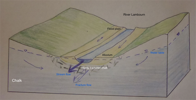
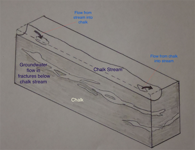
The water of a chalk stream and the water table in the ground around the stream can be considered as a continuous water body. There is a highly permeably fractured zone in the chalk below the stream bed. The chalk has been dissolved and eroded along the joints and fractures, forming conduits and pipes that allow groundwater to rise up into the stream, but also allowing stream water to sink back into the ground. The flow along a chalk stream can vary, local changes in water table level, due to variations in the valley gradient or the presence of highly fractured zones, can result in the chalk stream’s flow reducing in places, as the water is lost back into the ground.
The River Lambourn is almost unique for an English chalk stream as its flow regime remains in a near-natural in form; not being significantly modified by groundwater abstraction.
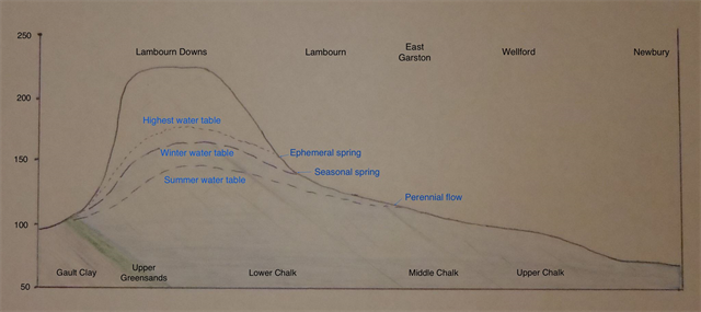
The head of a chalk streams varies during the year due to the seasonal variations in groundwater levels. For the River Lambourn the upper reach of the stream, from Lambourn to East Garston, is seasonal or intermittent and only flows when the water table feeding the river is high, usually between November and March. As the water table in the chalk drops during summer months the source of the stream migrates down stream. The seasonal section of a chalk stream is know as a bourn, winterbourne or bourne. The River Lambourn from below East Garston is perennial and usually flows all year, though can sometimes become dry to Great Shefford in exceptionally dry years.
To log this earth cache you will need to visit three locations and gauge the flow of the River Lambourn at each and answer the questions below.
Please take care as whilst the bridges are on quiet lanes, you will need to cross the road several times to assess the speed of the rivers flow under each bridge and several times at two of the bridges as they have three arches.
We parked in Boxford and cycled up and down the Lambourn valley. There is car parking on the road very close by each location and the cache should be accessible to all. There are many fine local village hostelries in the villages along the valley, should you need refreshments and there are also many other caches too.
You will need a tape measure, a 3m one would work but a 5m one would be better as they are less flexible or even better would be pole of some sort, to measure the depth of the water in the stream, which can be done from the bridge, and a stop-watch or means of timing.
So to gauge the flow, you will need to measure the depth, width and length of the channel under the bridge, all can be done to sufficient detail from the bridge and then time the speed of flow under the bridge, using a suitable stick or leaf. Yes pooh sticks is a valid scientific way of assessing river flow! Though to get a good quality assessment of the flow you will need to take care with your measurements to ensure they are of a suitable quality.
River flow is measured in meters cubed per second (m3/s) or cumecs, so it is best to make all the measurements in meters.

Questions:
Q1 What is the flow of the River Lambourn at the three locations?
Q2 What differences in flow rate are there between the three locations?
Q3 Explain why you think there are these differences.
N 51° 29.300 W 001° 28.490 – East Garston
N 51° 27.380 W 001° 24.670 – Wellford
N 51° 26.860 W 001° 23.235 – Near Boxford