Svenska (English below)

Från för drygt 100.000 år sedan till för omkring 10.000 år sedan så var det här området (och hela Skandinavien) täckt av ett tjockt lager inlandsis. Isen var som tjockast här; upp till tre kilometer tjock. När isen smälte så bar smältvattnet med sig en massa stenar av alla storlekar under isen. När de isälvarna kom ut från under isen så började de avlagra de stenar de hade fört med sig. Tyngre stenar sedimenterade först, så klart, medan mindre stenar fördes iväg längre med vattenströmmen innan de sjönk till marken.
Eftersom iskanten samtidigt drog sig tillbaka så ändrades platsen som de olika storlekarna av stenar avlagrades på över tiden. Detta innebar att rullstensåsar skapades med stora stenar på botten och sedan allt mindre stenar längre och längre upp.
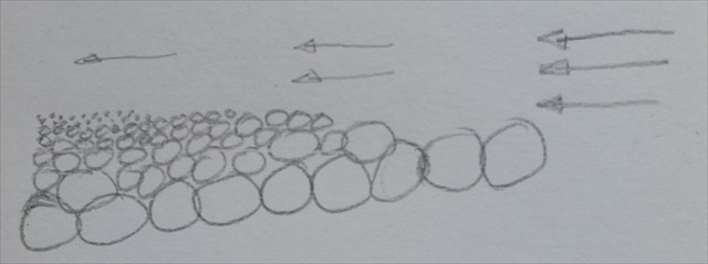
När en isälv hamnar på ett ställe där den utsätts för vågor så kommer de översta lagren av sand och småsten att sköljas bort och kvarlämna ett klapperstensfält. Eftersom områden som har täckts av inlandsisen trycktes ner av isens tyngd och nu stiger upp igen (på vissa ställen så mycket som nästan en centimeter om året, fortfarande idag) så kommer den exakta positionen för havsnivån att ändras vilket gör att den översta delen av rullstensåsen kommer att försvinna från en större yta. Man kan också att de olika nivåerna för havsnivån över tiden kan leda till att terrasser skapas.
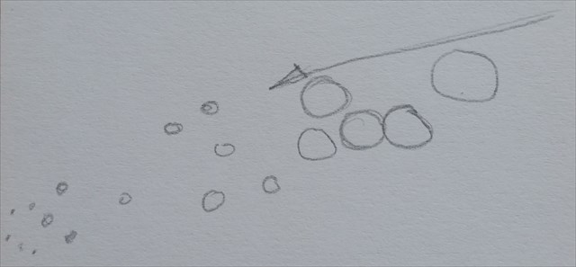
Den här earthcachen kommer att visa dig ett område med mellanstora stenar i form av ett terrasserat klapperstensfält. Om lagret av klappersten är tjockt nog så kommer frön som faller bland stenarna att sköljas till botten där det inte finns något ljus och kommer inte att kunna gro vilket gör att klapperstensfältet fortfarande syns idag, tusentals år efter att det skapades.
Frågor att svara på för att få logga cachen
- Beskriv de olika storlekarna på stenarna som utgör de olika terrasserna och gissa varför de är olika.
- Hur många stenterrasser kan du se på den norra sidan av spången, från vägen ner till där spången ändrar riktning?
- Hur stor är höjdskillnaden mellan den första och den sista av de här terrasserna?
- I vilken kompassriktning ligger terrasserna och varför tror du att det är så?
Skicka svaren till mig via min profil (skriv dem inte i loggen). Det går utmärkt att logga direkt när du har skickat in dina svar. Om något skulle vara fel så hör jag av mig, men annars inte.
English
From slightly over 100.000 years ago and up until about 10.000 years ago this area (and all of Scandinavia) was covered with a thick layer of inland ice. The ice was thickest here at up to three kilometers thickness. When the ice melted, the runoff water brought with it a lot of rocks of all sizes in streams under the ice cover. When the streams emerged from under the ice they started to deposit the rocks it transported. Heavier rocks were deposited first, of course, while smaller rocks travelled further with the water stream before settling on the ground.
Since the ice edge retreated at the same time, the points where different sizes of rocks were deposited changed over time. This caused eskers to be formed with large rocks at the bottom and then progressively smaller rocks further and further up.
When an esker ends up in a place where there is wave action, the top layers of sand and small rocks may be swept away leaving a shingle beach. Since areas that have been covered by inland ice were pressed down by the weight of the inland ice and now rise again (in some places by as much as almost a centimeter per year, still today), the exact location of the sea level will change, causing the top layer to be removed from a larger area. You may also see that the different locations of the sea level over time may cause terraces to be formed.
This earthcache will show you an area of middle-sized rocks in the form of a terraced shingle beach. If the layer of rocks is thick enough, seeds falling among the rocks will be swept toward the bottom where there is no light and won't be able to grow, leaving the shingle beach visible today, thousands of years after its formation.
Questions to answer to be allowed to log the cache
- Describe the sizes of the rocks making up the different terraces and speculate on why they are different.
- How many terraces of rocks can you make out on the north side of the wooden walkway, from the road down to where the walkway changes direction?
- How large is the elevation difference between the first and the last of these terraces?
- In what compass direction are the terraces arranged and why do you think that is so?
Send your answers to me via my profile (don't write them in your log). Feel free to log the cache immediately after sending me your answers. If there are any problems with your answers I will get back to you, but otherwise not.