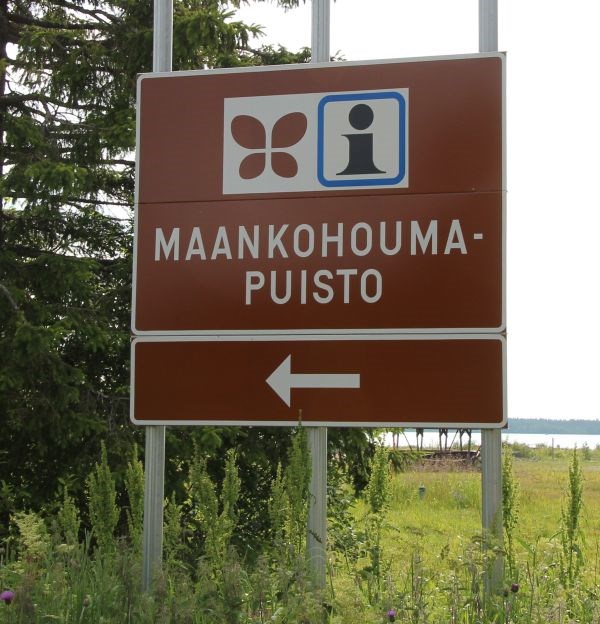
Simoon on vuonna 2013 perustettu maankohoumapuisto, joka esittelee jääkauden jälkeistä maan kohoamista. Puisto koostuu useista eri pisteistä, joissa voi nähdä kuinka maan kohoaminen vaikuttaa maisemaan.
Maankohoumapuiston viralliset sivut löytyvät osoitteesta:
http://www.maankohoumapuisto.fi/
Puiston virallisilla sivuilla on paljon tietoa jääkauden aiheuttamasta maan painumisesta ja animoituja esityksiä, kuinka maa on viimeisen 500 vuoden aikana kohonnut.
Tämä Earth-kätkö opettaa perusasioita maanpainumisesta viimeisen Suomessa vaikuttaneen jääkauden Veiksel’n aikana ja sen jälkeisestä maankohoamisesta. Suomessa maankohoaminen on voimakkainta Perämeren alueella, johon myös Simon maankohoumapuisto kuuluu.
Viime jääkausi Suomessa – Veiksel
Toistaiseksi viimeisestä jääkaudesta Suomessa ja koko Skandinaviassa käytetään nimitystä Veiksel. Kyseessä on lähes 100 000 vuotta pitkä ajanjakso, jolloin Suomea peitti lähes kolme kilometriä paksu mannerjäätikkö.
Veiksel-jääkautta aiemmin olleista jääkausista on useita teorioita, mutta tarkimmat jääkausitutkimuksen tulokset on saatu viime jääkaudesta eli Veikselistä. Aiempien jääkausien aikana Skandinavian tunturijonoille muodostui jäätiköitä, jotka laajenivat, levittäytyivät ja kasvoivat yhteen muodostaen Veikselin mannerjäätikön.
Suuri osa Skandinaviasta ei kuitenkaan ollut koko Veiksel-jääkauden ajan jään peitossa, vaan ilmasto vaihteli lämpimästä kylmempään ja takaisin. Lämpiminä ajanjaksoina jää suli osittain. Ilmaston jäähtyessä uudelleen jäätikkö levisi uusille alueille. Viimeisin suuri jäätiköityminen alkoi 30 000 vuotta sitten ja Suomi oli kokonaan jään peitossa 30 000-25 000 vuotta sitten.
Skandinaviassa valtavan jäätikön massa painoi maapallon sulan sisuksen päällä olevan mannerlaatan lommolle. Simon maankohoumapuiston alueella jään aiheuttama paine maata vasten oli noin 3000 tonnia neliömetriä kohti. Mannerjään aiheuttaman painauman syvyys vaihteli kymmenistä metreistä aina satoihin metreihin. Puiston alueella painauma oli noin 900 - 1 000 metriä syvä.
Ilmasto lämpeni tämän jälkeen vähitellen ja jää alkoi sulaa. Suomessa jään vetäytyminen alkoi noin 13 000 vuotta sitten. Jään sulaessa jääpeite oheni ja jäänreuna perääntyi. Yleisesti Veksel-jääkauden lasketaan päättyneen noin 10 000 vuotta sitten. Viime jääkauden kasvaminen tapahtui siis hitaasti, mutta sulaminen erittäin nopeasti.
 Svartisen jäätikköä Norjassa vuonna 2015. (C) Team HEP.
Jääkauden jälkeen – Maankohoaminen
Jäätikön sulaessa ja paineen hellittäessä mannerlaatan lommo alkoi oieta ja maa kohota kohti alkuperäistä muotoaan. Alussa maankohoaminen oli nopeaa, yli 100 mm vuodessa ja se hidastui vähitellen. Maankohoaminen Veiksel-jääkauden jälkeen jatkuu edelleen. Suomessa kohoaminen on suurinta Perämereen alueella, josta jääpeite suli viimeisenä. Maankohoumapuiston alueella maa nousee nykyään noin 9 mm vuodessa.
Simon maankohoumapuistossa voit tutustua koko Suomen maankohoamisnopeuksiin nykyaikana.
Maankohoamisen seurantamenetelmät
Maankohoamista voidaan seurata ja mitata useilla menetelmillä. Tieteellisesti mittaaminen on haasteellista, sillä merenpintaan suhteutetut mittaukset vaihtelevat merenpinnan korkeuden mukaan ja siihen vaikuttaa mm. sateiden määrä ja jäätiköiden sulaminen. Jäätiköiden sulaminen nostaa valtamerien merenpintaa 1,5 mm vuodessa (eustaatinen merenpinnan nousu). Perinteisesti kohoamisen nopeus ilmoitetaankin meriveden keskikorkeuteen nähden.
Merenpinnan korkeuteen perustuvia vesiasteikkoja ovat mm. mareografit, joita Suomen rannikolla on 13 kappaletta ja joita Merentutkimuslaitos ylläpitää.
Suomessa on aiemmin käytetty myös valtakunnallista tarkkavaaitusta, jotka on tehty vuosina 1892-1910, 1935-1975 ja viimeisin on valmistunut vuonna 2004. Tarkkavaaituksesta vastasi Suomen Geodeettinen laitos.
Maankohoamisen seurantamenetelmät kehittyvät kaikenaikaa ja osa vanhoista menetelmistä menettää merkitystään. Yksi uusimpia menetelmiä on mitata maankohoamista GPS-paikannuksella. GPS-mittausta on käytetty erityisesti pohjoismaissa ja sillä saadaan jo muutaman vuoden mittausten perusteella tarkka kuva maankohoamisesta. GPS-mittausta varten Suomessa on 13 pysyvää GPS-asemaa, joiden avulla maankohoamista voidaan määritellä geosentrisesti. Geosentrisessä määrittelyssä mittaus tapahtuu maan massakeskipisteeseen eikä keskimerenpintaan. GPS-mittauksella saadaan määriteltyä ns. absoluuttinen maankohoaminen suhteessa maapallon keskipisteeseen ja siinä on huomioitu eustaattinen merenpinnan nousu.
Edelleen kuitenkin käytetään myös vanhoja hyväksi havaittuja menetelmiä. Kauan käytössä olleita välineitä maankohoamisen seurannassa ovat olleet rannikkoalueiden vedenkorkeusmerkit ja kartat. Yhtä edelleen käytetään perimätietoa rannan sijainnista ja satamien mataloitumisesta maankohoamisen arvioissa. Simon maankohoumapuiston esittelyssä sanotaan, että alueen vanhimmat asukkaat muistavat vielä, miten merenranta oli lähempänä asutusta ja venevalkamat talojen lähettyvillä. Muutos on hidasta, mutta kylien vanhimmat muistavat meren pinnan laskeneen lähes metrin elinvuosiensa aikana.
Maan kohoamisen vaikutukset Suomessa
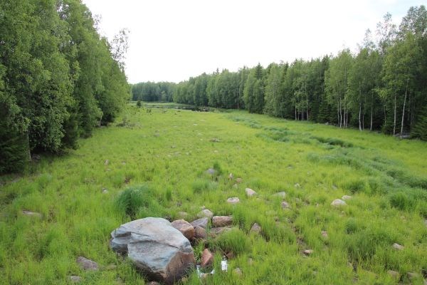
Simon maankohoumapuiston eri pisteet esittelevät selkeitä maankohoamiseen liittyviä muutoksia rantaviivassa. Nähtävissä on merestä nousevia uusia karikkoja, saarien yhdistymistä ja niemien kasvamista, jotka ovat tyypillisiä maankohoamisen vaikutuksia Suomessa. Maankohoamisen vaikutuksia ovat myös merenlahtien muuttuminen fladoiksi, sisäjärviksi ja kosteikoiksi sekä salmien madaltuminen.
Maankohoaminen kasvattaa nykyisellään maapinta-alaa vesijättömaana 100 hehtaaria eli noin 150 jalkapallokentällistä vuodessa.
Maankohoamisen seurauksena Suomi kallistuu, kun Perämeren alue nousee suhteessa enemmän muihin alueisiin nähden. Rantaviiva siiryy kauemmas merelle, jonka seurauksena joet pitenevät, niiden virtaus hidastuu ja tulvat kasvavat. Suurimmilla maankohoamisalueilla venevalkamat ja satamat jäävät kuivalle maalle ja niitä täytyy siirtää. Maannousu vaikuttaa myös kalastuspaikkojen sijaintiin. Rantojen edustalle muodostuvat matalikot saattavat vaatia ruoppausta, mikäli kesämökin rantaa haluaa käyttää uimiseen ja veneilyyn. Kunnille on muodostunut erilaisia tapoja jakaa rannasta nousevaa vesijättömaata.
Uusi rantaviiva muodostuu kallioperän, maaperän ja paikallisen ympäristön ominaisuuksien mukaan.
Tulevaisuuden arviot
On arvioitu, että maankohoaminen vuoksi Merenkurkku kuroutuu umpeen ja siihen syntyy maayhteys noin 2000 vuoden kuluttua. Tämä aiheuttaa Perämeren muodostumisen järveksi/sisämereksi. Perämerestä arvioidaan tulevan Euroopan suurin makeanvedenallas. Maan arvioidaan nousevan vielä tuhansia vuosia, mutta nousu hidastuu kaikenaikaa.
Kätkön koordinaatit tuovat sinut Vasankarin rantaan. Rannassa on laavu ja kaksi uimarantaa, yksi koirille ja yksi ihmisille.
Tehtävät:
1. Mene annettuihin koordinaatteihin. Seisot laiturin päässä. Kun katsot laiturin päässä oikealle, kuvaile näkemääsi maisemaa.
2. Miltä arvioit maiseman näyttävän 100 vuoden päästä? Entä 1 000 vuoden päästä? Mihin perustat näkemyksesi?
3. Infotaulussa koordinaateissa N 65° 37.642 E 025° 00.161 näet maan kohoamisen eri puolilla Suomea. Kuinka paljon maa kohoaa omalla paikkakunnallasi?
4. Koordinaateissa N 65° 38.684 E 025° 00.990 on silta. Kuvaile maisemaa sillan molemmin puolin. Kuinka tarpeelliseksi näet sillan nyt? Entä 50 - 100 vuoden päästä?
5. Optionaalinen: Ota kuva itsestäsi GPS-laitteen kanssa kätkön koordinaattipisteissä (siten, ettei maisema laiturilta oikeallepäin näy kuvissa).
Lähetä vastaukset profiililinkin kautta:
Lähetä viesti Team HEP:lle
Älä kirjoita vastauksia löytöloggaukseesi.
Voit logata käyntisi vastausten lähettämisen jälkeen, et tarvitse erillistä loggauslupaa. Jos vastauksissa on epäselvyyksiä, otamme yhteyttä.
Vesijättömaa
Merestä kokonneen maan valtaavat erilaiset rannikon pioneerikasvit muodostaen rantaniittyjä. Myöhemmin rannan valtaavat pensaat ja puut. Tyypillisesti ensin ehtivät paju, raita, leppä ja koivu ennen kuusta ja mäntyä.

Jokimaisemaa
Kasvillisuus valtaa vanhaa joenpohjaa.
LÄHTEET:
Käytetty 1.9.2015 versioita
1.) Simon maankohoumapuisto http://maankohoumapuisto.fi/
2.) Rummukainen Aune, Maankohoaminen ja sen vaikutukset Perämerellä, kevät 2013.ppt http://www.ulapland.fi/loader.aspx?id=f7c8396d-9138-4220-831e-9238a3865655
3.) Nykyinen maankohoaminen Satakunnassa http://www.pilvivene.com/suurijoki/index.php?option=com_content&view=article&id=39:nykyinen-maankohoaminen-satakunnassa&catid=11:jaeaekauden-seuraukset&Itemid=9
4.) e-Opin oppikirjat, eMaantieto: Suomen maantieto, Maankohoaminen https://peda.net/kannonkoski/e-opin-oppikirjat/suomi22/4mjj
5.) Syventävä esitelmä. Jääkausi ja maankohoaminen http://www.kvarken.org/assets/Undervisningsmaterial/Esitelmat-ja-kasikirjoitukset/Jaakausi-ja-maankohoaminen-kasikirjoitus.pdf

In 2013 was founded post-glacial rebound park in Simo that has multiple places showing how land is rising after the latest ice age.
The official web pages of the post-glacial rebound park can be found in below link:
http://www.maankohoumapuisto.fi/eng/
The official pages has lots of information about the ice age and how land is rising after that. There are lots of animated pictures showing how the landscape has been changed in the last five hundred years.
This Earth-cache teaches the basics of post-glacial rebound after the last ice age, Veiksel, in Finland. In Finland, the post-glacial rebound is strongest in the Gulf of Bothnia area, which also includes Simo post-glacial rebound park.
Last Ice Age in Finland - the Veiksel
So far, the last Ice Age in Finland and throughout Scandinavia is referred to as the Veiksel. This is nearly 100 000 years long period of time, when Finland was covered nearly three-kilometer thick ice sheet.
There has been number of theories about ice ages before the last one, but the most accurate results in Ice Age research has been from the last ice age, ie the Veiksel. During previous ice ages in Scandinavia glaciers were formed on top of the mountains, which were expanded, spread and grew together to form the Veiksel ice sheet.
However, a large part of Scandinavia was not covered with ice during the whole period of the Veiksel-Ice Age. The climate was ranging from warm to colder and back. During the warmer periods ice melted partially. Climate cools again the glacier spread to new areas. The last major glaciation began 30 000 years ago and Finland was completely ice-covered 30 000-25 000 years ago.
In Scandinavia, a huge mass of ice sheet on top of the Earth's continental plate pressed it on a dent. At Simo post-glacial park area ice caused a pressure against the ground that was approximately 3000 tonnes per square meter. The dent caused by the continental ice ranged from tens of meters to hundreds of meters. At the park area the dent was about 900 - 1 000 meters deep.
The climate warmed gradually, and the ice began to melt. In Finland, the ice retreat began about 13 000 years ago. The ice melts, the ice thinned, and the ice edge retreated. Generally Veksel-glacial period is calculated to end about 10 000 years ago. The last ice age was born slowly, but the melting was very quick.
Svartisen glacier in Norway, 2015. (C) Team HEP.
After the Ice Age - Post-glacial rebound
The glacier melted and the pressure eases off the continental plate and a dent in the earth started to rise towards its original form. At the beginning the rebound was rapid, with more than 100 mm per year, but it slowed down gradually. The post-glacial rebound after Veiksel ice age still continues. In Finland, the increase is the highest in the Bothnian Bay area, where the ice melted last. At the area of Simo post-glacial rebound park land rises about 9 mm per year.
At the Simo post-glacial rebound park you can observe how land is rising.
Post-glacial rebound monitoring methods
Post-glacial rebound can be monitored and measured by several methods. Scientifically measurement is a challenge, because the sea level height is influenced, for example, the amount of rainfall and the melting of glaciers. Melting glaciers raise the sea level of 1.5 millimeters per year. Traditionally, the increase in speed are stated with respect to sea water medium height.
For example tide gauges are used to measure sea level and post-glacial rebound. There are 13 tide gauges in Finland which are maintained by the Finnish Institute of Marine Research.
In Finland there has previously been used a national precise measurement, made in 1892-1910, 1935-1975 and the most recent was completed in 2004. Precise measurement was done by the Finnish Geodetic Institute.
Post-glacial rebound monitoring methods are developing all the time and some of the old methods are losing their significance. One of the latest methods is to measure the increase with GPS positioning. GPS measurements have been used, particularly in the Nordic countries. Only a few years of measurements give accurate picture of the post-glacial rebound. For GPS measurement there are 13 permanent GPS stations, which allow geocentric measurements. The geocentric measurement is based on the center of gravity, not in the average sea level. GPS measurement gives absolute land uplift relative to the Earth center and it takes into account the sea level rise.
However, the old tried and tested methods are still used. Sea level marks and maps have been used for a long time in post-glacial rebound measurements. Some of still used methods are traditional knowledge about location of the coastal line and port waters becoming increasingly shallower. In the description of Simo post-glacial rebound park it is said that the oldest inhabitants of the area still remember how the seaside was closer to residential areas and boat havens were nearby. Change is slow, but the elders of the villages say that the sea level dropped by nearly a meter during their lifetime.
The effects of post-glacial rebound in Finland
Different points of Simo post-glacial rebound introduce significant changes related to the change in the coastline. It can be seen that new reefs and islands rise from the sea and older islands join to the mainland, which are typical effects of land uplift in Finland. The effects of the land uplift are also changing gulfs to flada, inland lakes and wetlands.
Uplift increase the current land area about 100 hectares, or about 150 soccer fields in a year.
As a result of land uplift Gulf of Bothnia region rises proportionally more in relation to other regions. The coastline moves further out to sea and rivers are getting longer, the flow slows down and the floods will increase. At the largest land uplift areas boat havens and harbors will be left on dry land, and they have to move. The land uplift also affect the fishing grounds. The beaches might require dredging, if the summer houses near to the beach wants to use beach for swimming and boating.
Future estimations
It is estimated that the post-glacial rebound will form a land bridge in about 2,000 years in Merenkurkku. This causes the Gulf of Bothnia to change to a lake / inland sea. Bothnian Bay is expected to become Europe's largest freshwater pool. The land is expected to rise even thousands of years, but the rise will slow down all the time.
The listed coordinates are at the beach of Vasankari. There are two swimming beaches, one for dogs and one for people.
Tasks:
1. Go in the listed coordinates. You are standing at the end of a pier. When you look at right, describe the landscape you are seeing.
2. Estimate how the landscape looks after 100 years from now. Estimate also how the landscape will look after 1 000 years from now. On what you base your answers?
3. In the information board at N 65° 37.642 E 025° 00.161 you see how much land rises in different parts of Finland. How much land rises at the place you live, if you are from Finland. If you're foreigner, do you know does land rise in the country you live?
4. At N 65° 38.684 E 025° 00.990 there is a bridge. Describe the landscape to the right and left from the bridge. Is the bridge necessary now? How about after 50-100 years, is the bridge still needed there?
5. Optional: Take picture of yourself and GPS at the listed coordinates (so that you do not show the landscape that is needed in the first question).
Send the answers to us using the link below:
Send message to Team HEP
Do not write your answers to the log in geocaching.com.
You can log the cache after your visit. If there's something unclear in your answers, we will contact you.
Alluvion
Different kind of plants are growing on the land that rose from the sea. First there will be beach meadow, and later bushes and trees.
River landscape
Vegetation growing on the old riverbed.
REFERENCES:
As 1.9.2015.
1.) Simon maankohoumapuisto http://maankohoumapuisto.fi/
2.) Rummukainen Aune, Maankohoaminen ja sen vaikutukset Perämerellä, kevät 2013.ppt http://www.ulapland.fi/loader.aspx?id=f7c8396d-9138-4220-831e-9238a3865655
3.) Nykyinen maankohoaminen Satakunnassa http://www.pilvivene.com/suurijoki/index.php?option=com_content&view=article&id=39:nykyinen-maankohoaminen-satakunnassa&catid=11:jaeaekauden-seuraukset&Itemid=9
4.) e-Opin oppikirjat, eMaantieto: Suomen maantieto, Maankohoaminen https://peda.net/kannonkoski/e-opin-oppikirjat/suomi22/4mjj
5.) Syventävä esitelmä. Jääkausi ja maankohoaminen http://www.kvarken.org/assets/Undervisningsmaterial/Esitelmat-ja-kasikirjoitukset/Jaakausi-ja-maankohoaminen-kasikirjoitus.pdf