
Projekt TWIERDZA KOŁOBRZEG to 12 skrytek usytuowanych na trasie Miejskiego Szlaku Fortfikacji (ok. 12 km długości). W celu znalezienia finałowego kesza , należy odszukać 10 skrytek. Osiem z nich zawiera cyfry potrzebne dla określenia współrzędnych, a dwie klucze niezbędne do określenia lokalizacji skrytki Fort Wilczy. Dlatego nieodzowne jest spisanie danych z dziesięciu z nich. Jedna skrytka nie posiada żadnych informacji. Wszystkie kesze oznaczone są numerami wyznaczającymi najdogodniejszą trasę poszukiwań. Stąd też #1 przy oznaczeniu Parku Dąbrowskiego. Więcej informacji w keszu finałowym FORT WILCZY.Miłej zabawy!
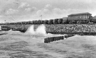
Budowę szańca (Waldenfelsa) rozpoczęto w 1832, gdy fortyfikacje kołobrzeskiej twierdzy przechodziły modernizację i rozbudowę. Miał kształt redanu. Zbudowany był z dwóch wałów ziemnych z kazamatami oraz fosy od strony północnej i wschodniej. Od strony morza zabezpieczony był wałem z głazów. Wejście do szańca znajdowało się od strony zachodniej. W XIX wieku, gdy Kołobrzeg stawał się modnym uzdrowiskiem, zniesiono wiele śladów i pozostałości po wojennej przeszłości miasta.
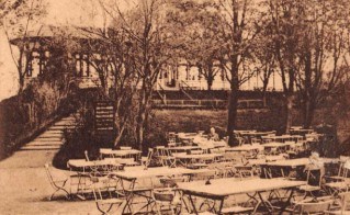
Wtedy to teren ten zaczęto przystosowywać do celów rekreacyjnych. Zasypano część fosy, posadzono drzewa, wewnątrz zbudowano ogrodową restaurację, a na wale, od strony morza, powstała kawiarenka w formie oszklonej werandy z tarasem. Szaniec Waldenfelsa do końca XIX wieku był pięknym miejscem widokowym i ulubionym celem wycieczek. Na szańcu znajdowało się również miejsce poświęcone zastępcy komendanta twierdzy z 1807 roku – Karolowi von Waldenfels, który dowodząc atakiem grenadierów na Fort Wilczy, poniósł w okolicy śmierć podczas walki. Stąd też dawna nazwa tego dzieła: Waldenfelsschanze. W marcu 1945 szaniec przystosowano do obrony okrężnej. W czasie walk podczas II wojny światowej, obiekty gastronomiczne zostały całkowicie zniszczone. Szaniec był silnym punktem niemieckiej obrony.
Źródło: www. twierdzakolobrzeg.pl
OPIS SKRYTKI
1. Znajdź info na tablicy przy wejściu:
A = ostatnia cyfra roku zakończenia budowy szańca
B = ostatnia cyfra roku likwidacji szańca
2. N 54° 11.255-(AA)
E 15° 35.522-(BB)

The project FORTRESS KOŁOBRZEG is 12 caches located on the route of Municipal Fortification Trail( approx. 12 km long ) . In order to find the final cache , you must find 10 caches . Eight of them contain the numbers needed to determine the coordinates and in two of themthere are keys necessary to determine the location of the cache Fort Wilczy (Wolfsberg) . Therefore, it is essential to write down data from ten of them. One cache does not have any information. All caches are numbered defining the most convenient route of cache search. Hence the Dabrowski Park is labeled as #1. More info in the final cache FORT WILCZY. So have fun !
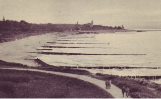
The construction of Stone Rampart (alt. Waldenfels') began in 1832, when the fortifications fortress of Kolobrzeg was being modernized and upgraded. It had a redan shape. It was constructed from two earthworks with casemates and moats from the north and east. Since the sea was secured by the shaft with boulders. The entrance to the rampart was located on the west side. In the nineteenth century, when Kolobrzeg became a fashionable spa, they abolished many remains of the wartime of the city.
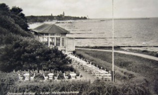
Then the was adopted for recreational purposes. The moat was covered, some trees were planted, a garden restaurant was built and on the shaft from the sea side a glass-fronted café with a terrace porch was located. The Waldenfel's Rampart was a beautiful panoramic place and a favorite tourist destination at the end of the nineteenth century. There was also a place dedicated to the deputy commandant of the fortress to 1807 - Charles von Waldenfels, which proving grenadiers attack on Lupine Rampart , was killed during the combat. Hence the old name for this place: Waldenfelsschanze. In March 1945, the entrenchment was adapted to the circular defence. During the combat, the catering facilities were completely destroyed. The rampant was also the strong point of the German defense.
Source: www. twierdzakolobrzeg.pl.
THE CACHE
1. Find the info on the board at the gate:
A = the last digit of the year when the rampart was built
B = the last digit of the year of its shutdown
2. N 54° 11.255-(AA)
E 15° 35.522-(BB)