LE LAC DE MONTCINEYRE: L'EAU ET LE FEUX EarthCache
LE LAC DE MONTCINEYRE: L'EAU ET LE FEUX
-
Difficulty:
-

-
Terrain:
-
Size:  (other)
Please note Use of geocaching.com services is subject to the terms and conditions
in our disclaimer.
LE LAC DE MONTCINEYRE
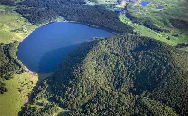
 Le Lac de Montcineyre est un lac situé à 1182 mètres d’altitude, dans le Massif du Mont-Dore, sur la commune de Compains dans le département du Puy-de-Dôme. Il s’agit d’un lac de barrage formé à la suite de l’éruption du Puy Montcineyre (1331m) : ses coulées de lave ont barré le cours de la rivière qui coulait là il y a de ça 6 millénaires. Ce lac est très reconnaissable grâce à sa forme de croissant et se distingue ainsi de ses nombreux voisins (le Lac Pavin, le Lac Chauvet entre autres). Il s’étend sur 40 hectares et sa profondeur atteint les 18 mètres.
Pour valider cette Earth Cache:
A) rendez vous en : N 45° 27.726 E 002° 54.183, et répondez aux questions suivantes
1) Qu'est ce que le site abrite de précieux?
2) Qu'elle est la forme des bombes volcaniques que l'on peut trouver à la base du cône?
3) Jusqu'à combien de Kms, a t'on retrouvé des cendres du Volcans
B) Devant l'entrée du lac il y a un transformateur. Indiquez moi le nom inscrit sur la plaque blanche, au dessus de "DANGER de MORT"
C) Facultatif: une photo de vous, ou de votre GPS au bord du lac.
Merci de m'envoyer vos réponses par mail et d'attendre ma réponse pour loguer.
 Montcineyre Lake is a lake located 1,182 meters above sea level in the Mont-Dore, in the municipality of Compains in the Puy-de-Dome. This is a barrier lake formed after the eruption of Puy Montcineyre (1331m): its lava flows have crossed the course of the river that flowed out of that there are six millennia. This lake is very recognizable thanks to its crescent shape and is thus distinguished from its many neighbors (Lake Pavin Lake Chauvet among others). It covers 40 hectares and its depth reaches 18 meters.
To validate this Earth Cache:
A) Go to: N 45 ° 27,726 E 002 ° 54,183, and answer the following questions
1) What is the site houses to precious?
2) What is the shape of volcanic bombs that can be found at the base of the cone?
3) Up to how many Kms, it has found you Volcano Ash
B) In front of the lake entrance there is a transformer. Show me the name on the white plate, above "DANGER de MORT"
C) Optional: a picture of you or your GPS at the lake.
Thank you send me your answers by email and wait for my answer to login.
Additional Hints
(No hints available.)