Le cordon dunaire :
Le cordon dunaire, ininterrompu sur une distance de 11 km au milieu du XIXe siècle depuis Dunkerque jusqu'à la frontière franco-belge, s'est progressivement réduit par suite de l'urbanisation aux abords de Dunkerque, et de l'arasement lors de la construction de perrés à Malo (Delépine, 1920) qui ont acquis une extension proche de l'actuelle vers 1947 (plus de 4 km).
Actuellement, il se compose de trois massifs : les dunes de Leffrinckoucke et de Ghyvelde à l'ouest, la dune de l'Hôpital Maritime et la dune Marchand au centre, et la dune du Perroquet à l'est, prolongée au-delà de la frontière franco-belge par le massif du Westhoeck.
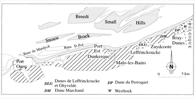
Ces trois massifs d'orientation générale WSW-ENE, séparés par les villes côtières de Zuydcoote et Bray-Dunes, occupent un linéaire côtier de 6km. Leur largeur passe progressivement de 700 m l'ouest à plus de 1100 m à l'est au niveau de la frontière.
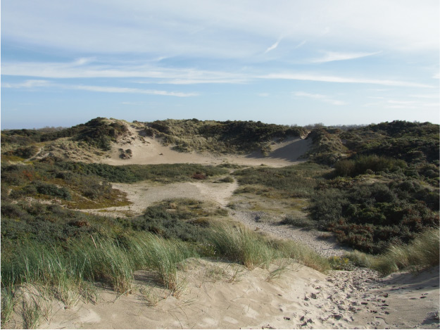
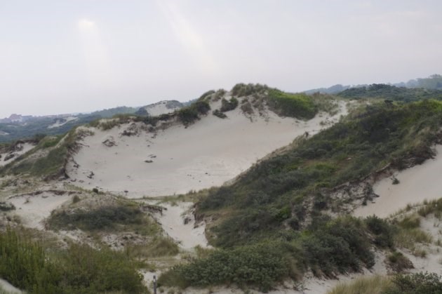
Structurés de manière identique, ils comprennent du sud vers le nord un bourrelet interne, une plaine interdunaire basse à l'altitude 4 à 5 m NGF accidentée de dunes paraboliques atteignant 15 à 30 m NGF, et une dune bordière.
Type et forme de dune :
On nomme « dune littorale » le bourrelet dunaire parallèle à la côte et dominant la plage. Il n’est souvent constitué que d’un unique « cordon » bordant le littoral.
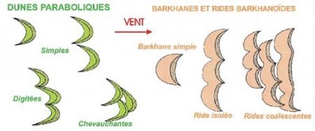
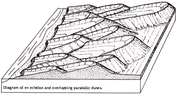
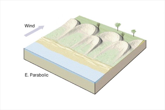
On distingue deux grands types de dunes selon que les « cornes » des croissants sont tournées vers le vent (« dunes paraboliques ») ou tournées sous le vent (« barkhanes » ou « rides barkhanoïdes »).
Les dunes paraboliques peuvent s’associer en chaîne, on les qualifie alors de digitées ou en massif de dunes se recouvrant plus ou moins l’une et l’autre et elles sont dites « chevauchantes ».
Les barkhanes sont souvent associées en forme de ride unique. Ces rides peuvent se grouper en massif de rides coalescentes.
Formation des dunes :
Les dunes se sont formées par l’interaction entre le transport de sable par le vent et la couverture végétale. Elles ont été alimentées en sable par la plage.
Les paramètres qui président à la formation des dunes côtières sont :
- la force du vent de mer, le transport de sable sera d’autant plus important que le vent est plus fort,
- la quantité de sable mobilisable, liée par exemple à l’amplitude de la marée et/ou au « budget sédimentaire » de la plage,
- la nature et la densité de la couverture végétale, qui pourra freiner le sable et favoriser ainsi son accumulation, ou bien, si le couvert végétal se développe rapidement, fixer le sable et empêcher le déplacement des dunes.
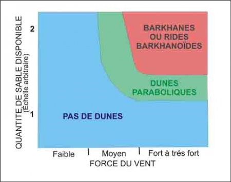
Selon la quantité de sable disponible et la force du vent, il se formera soit des dunes paraboliques soit des barkhanes ou des rides barkhanoïdes, isolées ou coalescentes.
Dunes paraboliques de la Côte d'Opale :
Les dunes paraboliques de la Côte d'Opale se sont formées suite au refroidissement du climat et à une baisse des niveaux d'eau en mer. En effet, cet abaissement des niveaux d'eau a exposé le sable et les sédiments au vent : ceux-ci ont été transportés par l'effet éolien et se sont accumulés au fil des années en retrait des côtes actuelles. Les bras des dunes ainsi formés ont été ensuite rapidement colonisés par la végétation, grâce au climat humide qui régnait à cette époque. Celle-ci a alors fixé le sable et arrêté sa progression aux extrémités, tandis qu'au centre, le sable a continuer à avancer. Aujourd'hui la plupart de dunes paraboliques sont stabilisées et fortement végétalisées.
Le plus souvent, une panne humide se crée au coeur de la dune parabolique. La panne est une dépression humide creusée par le vent atteignant la nappe phréatique. Les pannes sont également alimentées par de l'eau de pluie, et généralement en eau tout l'hiver, tandis qu'en été elles peuvent s'assécher complètement.
Elles présentent une morphologie variable selon les conditions hydrologiques et de salinité, ce qui permet à une grande diversité d'espèces floristiques et faunistiques de s'y installer.
Earthcache :
Pour valider la cache, vous devez répondre aux questions suivantes dont certaines réponses figurent sur le panneau situé aux coordonnées de la cache, les autres permettront de s'assurer que vous avez appris des choses avec cette cache :
- 1 - A quelle lettre de l'alphabet peut-on comparer une dune parabolique ?
- 2 - Citez un couple (quantité de sable/force du vent) permettant le formation d'une dune parabolique. Exemple : (1,5/Faible) - ce n'est pas une réponse correcte.
- 3 - Quelle est la direction du vent qui a permis la construction des dunes paraboliques de la Côte d'Opale ?
- 4 - Quand ont été formées les dunes paraboliques de la Côte d'Opale ?
- 5 - Quel type de triton peut-on rencontrer dans la panne humide ?
Vous pouvez loguer "Found it", et me transmettre les réponses par mail ou par message via le site geocaching.com, et je vous contacterai en cas de problème.
ENGLISH VERSION
The dune cordon :
The dune, continuous cordon on a distance of 11 km in the middle of the XIXth century since Dunkirk until the French-Belgian border, was gradually reduced as a result of the urbanization around Dunkerque, and around the arasement during the construction of perrés to Malo (Delépine, on 1920) which acquired an extension close to the current by 1947 (more than 4 km).
At present, it consists of three massifs : the dunes of Leffrinckoucke and Ghyvelde on the West, the dune of the Maritime Trade Hospital and the dune in the center, and the dune of the Parrot in the East, extended beyond the French-Belgian border by the massif of Westhoeck.
These three massifs of general orientation WSW-ENE, separated by the coastal cities of Zuydcoote and Bray-Dunes, occupy a coastal shelf space of 6km. Their width increases gradually 700 m the West in more than 1100 m in the East at the level of the border.
Structured in a identical way, they understand of the South northward an internal roll, a low interdune plain at the height 4 - 5 m NGF damaged of reaching parabolic dunes 15 in 30 m NGF, and a bordering dune.
Type and shape of dune :
We name " littoral dune " the dune roll parallel to the coast and dominating the beach. It is often constitute only by a unique "cordon" lining the coast.
We distinguish two big types of dunes as the "horns" of croissants are turned to the wind ("parabolic dunes") or turned(shot) under the wind ("barkhanes" or "wrinkle barkhanoïdes").
The parabolic dunes can join in chain, we consider them then as digitées or in massif of dunes recovering more or less both and they are said "overlapping".
Barkhanes is often associated in the shape of unique wrinkle. These wrinkles can group in massif of coalescentes wrinkles.
Formation of dunes :
Dunes formed by the interaction between the transport of sand by the wind and the plant cover. They were fed with sand by the beach.
The parameters which preside over the formation of the coastal dunes are :
- the sea strength of the wind, the transport of sand will be important all the more as the wind is stronger,
- the quantity of mobilizable sand, connected for example to the amplitude of the tide and/or to the "sedimentary budget" of the beach,
- the nature and the density of the plant cover, which can slow down the sand and favor so its accumulation, either, if the plant place setting quickly develops, to fix the sand and to prevent the movement of dunes.
According to the quantity of available sand and the strength of the wind, it will form either parabolic dunes or barkhanes or barkhanoïdes, isolated or coalescentes wrinkles.
Parabolic dunes of the Côte d'Opale :
The parabolic dunes of the Côte d'Opale formed further to the cooling of the climate and to the reduction in the levels of water at sea. Indeed, this reduction in the levels of water exposed the sand and the sediments to the wind: these were transported by the wind effect and accumulated over the years set back from the current coast. The arms so formed of dunes were colonized then quickly by the vegetation, thanks to the wet climate which reigned at that time. This one then fixed the sand and stopped its progress in the extremities, whereas in the center, the sand has to continue to move forward. Today most of the parabolic dunes are stabilized and strongly vegetated.
Most of the time, a wet breakdown builds up itself at the heart of the parabolic dune. The breakdown is a wet depression dug by the wind affecting the groundwater. The breakdowns are also fed by some rainwater, and generally with water all winter long, whereas in summer they can dry up completely.
They present a variable morphology according to the hydrological conditions and of salinity, what allows a big diversity of floral species and faunistiques to settle down there.
Earthcache:
To validate the hiding place, you have to answer the following questions certain answers of which appear on the board situated in the address and phone number(coordinates) of the hiding place, the others will allow to make sure that you learnt things with this hiding place :
- 1 - With what letter of the alphabet can we compare a parabolic dune ?
- 2 - Quote a couple (quantity of sand / strength of the wind) allowing formation of a parabolic dune. Example : (1,5 / Faible) - it is not a correct answer.
- 3 - What is the wind direction which allowed the construction of the parabolics dunes of the Côte d'Opale ?
- 4 - When were formed the parabolic dunes of the Côte d'Opale ?
- 5 - What type of triton do we can met in the wet breakdown ?
You can log "Found it" and send me the reponses by mail or by message on geocaching.com website, and I'll contact if there is a problem.
Nederlandstalige versie
De duinengordel : :
De duinengordel, die in die 19° eeuw ononderbroken doorliep over 11 km van Duinkerken tot aan de Belgisch-Franse grens, is beetje bij beetje gekrompen door stedelijke ontwikkeling rond Duinkerken en door de aanleg van stenen dijken en taluds in Malo (Delépine, 1920), tot omstreeks 1947 min of meer de huidige omvang is bereikt (ruim 4 km).
Op dit moment bestaat ze uit drie deelgebieden: de duinen van Leffrinckoucke en Ghyvelde in het westen, de duinen van Hôpital Maritime en de Marchand-duin in het midden en in het oosten de Perroquet-duinen die aan de andere kant van de Belgisch-Franse grens overgaan in de Westhoek-duinen.
De paraboolduinen van de Côte d'Opale zetten zich voort aan de andere kant van de grens. Deze drie deelgebieden zijn WSW-ENE georiënteerd en zijn van elkaar gescheiden door de badplaatsen Zuydcoote en Bray-Dunes en strekken zich uit over in totaal 6 km kust. De breedte is 700 m in het westen en neemt geleidelijk aan toe tot 1100 m in het oosten, ter hoogte van de grens.
De structuur is overal gelijkaardig : in het zuiden de binnenduinen en in het noorden de zeereepduinen of voorduinen, en tussen deze duinen in een de laaggelegen vlakke pannengordel op 4 à 5 m NGF onderbroken door paraboolduinen die een hoogte van 15 à 30 m NGF bereiken.
Vormen en types van duinen :
Met "zeereep" duidt men de duinengordel of strandwal aan die parallel met de kust loopt en die het strand overziet. Op veel plaatsen is zijn de zeereepduinen de enige rij duinen.
Men deelt mobiele duinen in in twee grote klasses, volgens de oriëntatie van de "armen" ten opzichte van de wind. Bij "paraboolduinen" zijn die gericht naar de overheersende wind toe en bij "sikkelduinen" windafwaarts.
Paraboolduinen kunnen zich samenvoegen en een keten vormen (die dan lijkt op de vingers aan een hand = digitées) of ook over elkaar heen lopen (chevauchantes).
Sikkelduinen groeperen zich vaak in één golf (ride isolée). Die golven kunnen samen clusters vormen van elkaar overlappende golven sikkelduinen (rides coalescentes).
Duinvorming :
Duinen ontstaan door de interactie tussen zandtransport door de wind enerzijds en de begroeiing anderzijds. Het zand voor de duinen is afkomstig van het strand.
De belangrijkste factoren bij de vorming van kunstduinen zijn :
- windsterkte (force du vent), hoe krachtiger de wind, hoe meer zandtransport, ,
- de hoeveelheid beschikbaar zand (quantité de sable disponible), die op zijn beurt afhangt van de omvang van het getij en van de mate waarin het strand aangroeit door sedimentatie,
- de aard en de dichtheid van de begroeiing, die het zand afremt en op die manier de opeenhoping van zand stimuleert of anders gezegd, als de begroeiing mee-evolueert kan ze het zand fixeren en verhinderen dat de duinen zich verplaatsen.
De hoeveelheid zand en de windsterkte bepalen uiteindelijk of er paraboolduinen of sikkelduinen of clusters van sikkelduinen ontstaan.
Paraboolduinen aan de Côte d'Opale :
De paraboolduinen van de Côte d'Opale zijn ontstaan als gevolg van de afkoeling van het klimaat en de daling van het zeeniveau. Door de daling van het zeeniveau lagen zand en andere afzettingen bloot en had de wind vrij spel : het zand werd dus door de wind getransporteerd en accumuleerde zich in de loop der jaren op de kustlijn die vervolgens terugtrok tot op de huidige kustlijn. De armen van de duinen die zo gevormd werden werden vervolgens snel gekoloniseerd (dank zij het vochtiger wordende klimaat van die periode). Die begroeiing remde de verdere verplaatsing af aan de uiteinden maar in het centrum kon het zand zich verder verplaatsen. Op dit ogenblik zijn de paraboolduinen grotendeels vastgelegd en sterk begroeid.
Vaak ontstaat er in het hart van de paraboolduin een vochtige panne. Die panne is een vochtige depressie die door de wind wordt leeggeblazen tot de grondwatertafel is bereikt. De pannen zijn gevoed met regenwater. Vaak staan ze de hele winter onder water maar in de zomer kunnen ze volledig droogvallen.
De paraboolduinen vertonen dus een wisselende morfologie met variatie in vochtigheid en zoutgehalte, wat een grote variatie aan fauna en flora toelaat.
Earthcache :
Om de cache te kunnen loggen moet u het antwoord geven op volgende vragen. Sommige antwoorden zijn te vinden op het infobord op de coördinaten van de cache, andere hebben als doel om te kijken of u van deze cache iets opgestoken heeft :
- 1 - Met welke letter van het alfabet kan men een paraboolduin vergelijken ?
- 2 - Noem een combinatie (van hoeveelheid beschibkaar zand / windsterkte) die het ontstaan van paraboolduinen toelaat. Bijvoorbeeld (1,5/Faible) - dat is niet het juiste antwoord.
- 3 - Welke windrichting liet de opbouw van paraboolduinen toe aan de Côte d'Opale ?
- 4 - Wanneer werden de paraboolduinen van de Côte d'Opale gevormd ?
- 5 - Welk type salamander (triton) kan men aantreffen in een vochtige panne la (panne humide ?)
U mag een "Found it" loggen en me tegelijkertijd de antwoorden bezorgen per e-mail of met een boodschap op site geocaching.com. Ik contacteer u als er iets niet in orde is.