Stoke Mandeville is a large village bordering the town of Aylesbury, probably most notable for the hospital of the same name.
There has not always been a church on the site of the current St Mary's. The site of the old church, and indeed the ancient village of Stoke Mandeville sits a few hundred feet away along the Risborough Road. However the entire face of the village changed unrecognisably in the early 19th century.
In the early 1830s large swathes of the Aylesbury Vale were struck by severe flooding. Entire communities were completely submerged and some were lost altogether: Quarrendon, to the north of Aylesbury, was one village that was almost completely swept away. Some parts of the local area were submerged for some weeks, Stoke Mandeville being one of them. And the flood water brought with it a much greater danger: cholera.
In the early 1830s as many as a third of the population of Stoke Mandeville died after contracting cholera from the flood water. The disease was particularly punishing on the very old, and the very young. At the time a field hospital was established on the border between the parishes of Stoke Mandeville and Aylesbury, to try and manage those that were contagious with the infection from the two parishes. This infectious diseases hospital grew and grew, and became what is now known as Stoke Mandeville Hospital.
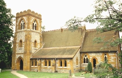
As the flooding subsided many of the village residents moved more upland to the site of the main village today, around the junction between Risborough Road, Lower Road and Swallow Lane. It was thus on this site, in the 1860s, that the new village church was built to better serve the villagers.
The old church ruin remained in place until very recently, but has now been cleared to make way for HS2.
Onto this cache!
Well this is embarrassing! I've hidden the cache but I can't remember where! Must be middle age creeping up on me, with the grey cells starting to give up the ghost. I can remember hiding the cache at the base of a big tree in a field, and I didn't cross any roads to get back to the church. I did climb over a stile, and I can remember going through a gate. Or was it two gates?
I glanced at my GPS device after I hid the cache and it said I was 370 metres roughly north west from the church. The cache is a small silver tin, and is very close to a public footpath.
Can you help find the cache?
****************** ********************
For full information on how you can expand the Church Micro series by sadexploration please read the Place your own Church Micro page before you contact him at churchmicro.co.uk
See also the Church Micro Statistics and Home pages for further information about the series.
****************** *******************