3/9 PT DA LAGOA DO FOGO
TRILHO DA LEVADA
Português

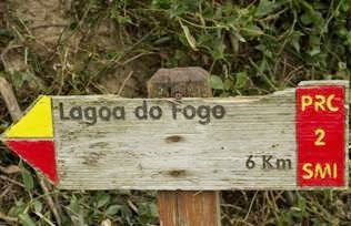
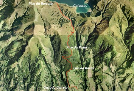
Este PT (power trail) é constituído por nove caches; oito tradicionais e uma bónus (enigma). Pretende dar a conhecer o trilho PRC2SMI, que começa na Ribeira da Praia e termina na margem da Lagoa do Fogo.
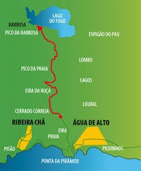
Trilho Praia – Lagoa do Fogo – S. Miguel
PRC2SMI
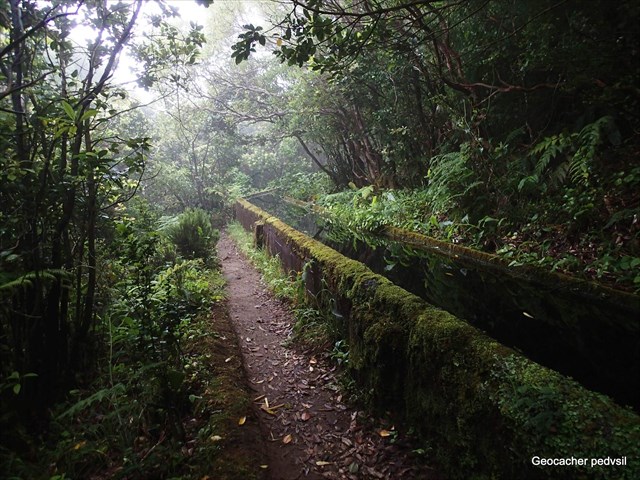
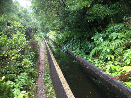
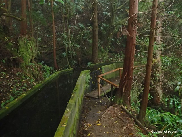
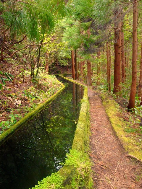
Este trilho inicia-se por um caminho de terra batida numa zona de pastagens, até chegar a um tanque de água onde se volta à direita iniciando a subida por entre uma mata de eucaliptos, incensos (Pittosporum undulatum), acácias (Acacia sp.) e conteiras (Hedychium gardneranum). Um pouco à frente encontram-se também vários exemplares de espadana, uma planta proveniente da Nova Zelândia que era fiada e tecida numa antiga fábrica cujas ruínas ainda se podem visitar. Seguindo sempre a sinalética chega-se ao início de uma levada ao longo da qual o trilho prossegue. É contudo necessário ter algum cuidado porque este caminho pode encontrar-se um pouco enlameado. Ao longo da levada encontram-se numerosos exemplares de plantas endémicas como Uva da Serra (Vaccinium cylindraceum), Urze (Erica azorica), Folhado (Viburnum tinus), Tamujo (Myrsine retusa), etc. Durante a subida existem vários locais onde se pode desfrutar de uma magnífica vista para a costa Sul de São Miguel, avistando-se Vila Franca do Campo, o seu Ilhéu e a Ribeira da Praia. Após caminhar cerca de 2km pela levada chega-se a uma zona mais aberta, com grandes encostas de ambos os lados e, caminhando mais um pouco, chega-se à margem da Lagoa do Fogo. Nesta zona é necessário algum cuidado com as gaivotas pois estas podem-se tornar muito agressivas, especialmente na época de nidificação (abril - maio). O regresso pode ser efetuado pelo mesmo caminho. O percurso encontra-se quase na sua totalidade dentro de uma zona classificada como Reserva Natural. É responsabilidade de todos nós contribuirmos para a sua proteção, bem como assegurar a sua biodiversidade através da conservação deste habitat natural.
INFORMAÇÕES
Categoria - Linear
Dificuldade - Médio
Extensão - 12.6 km
Tempo Médio - 4h30
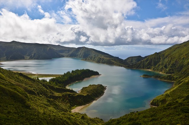
LAGOA DO FOGO
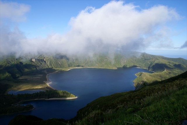
Faz parte integrante da Rede Natura 2000, pelo facto de ter sido classificada como zona especial de conservação, aprovado por Decisão da Comissão Europeia no dia 28 de Dezembro de 2001, nos termos da Diretiva Habitats 92/43/CEE do Conselho. Esta lagoa de águas muito azuis ocupa uma área de 1 360 ha, que é bastante tendo em atenção as dimensões da própria ilha.
O vulcão do Fogo dá forma ao grande maciço vulcânico da Serra de Água de Pau, localizado na zona central da Ilha de São Miguel. Toda esta zona é rodeada por uma densa e exuberante vegetação endémica.
A caldeira vulcânica, tal como o vulcão, que lhe deu forma, é a mais jovem da Ilha de São Miguel e ter-se-á formado há cerca de 15 000 anos. A sua configuração atual é resultado do último colapso, tido como importante e que ocorreu no topo do vulcão, há aproximadamente 5 mil anos. A última erupção data de 1563.
Esta lagoa, é também a mais alta da Ilha de São Miguel, facto que se deve a se encontrar no cimo de uma montanha cujo ponto mais alto se eleva a 949 metros. Localiza-se no topo do grande vulcão do Fogo, também conhecido como vulcão de Água de Pau. A caldeira tem forma de colapso tem forma elíptica e dimensões aproximadas de 3 x 2,5 km. As paredes desta caldeira chegam a atingir desníveis de 300 metros.
A lagoa, devido a se encontrar no centro da caldeira, localiza-se a uma cota bastante mais baixa, encontrando-se a 575 metros. A profundidade máxima atingida nesta lagoa são os 30 metros. Dentro de todo o perímetro da reserva natural, lagoa, caldeira, e vertentes da mesma, destacam-se bastantes espécies de plantas endémicas dos Açores: é o caso do cedro-do-mato (Juniperus brevifolia), o louro (Laurus azorica) e o sanguinho (Frangula azorica). Surgem ainda a malfurada (Hypericum foliosum), a urze (Erica azorica) e o trovisco-macho (Euphorbia Stygiana).
A principal fauna, aqui representada pelos pássaros de pequenas dimensões é muitas vezes acompanhada por aves de grande porte como as aves de rapina. Assim, surge nos ares da lagoa, além das aves caracteristicamente terrestres como o pombo-torcaz-dos-Açores (Columba palumbus azorica), o milhafre ou queimado (Buteo buteo rothschildi), a alvéola-cinzenta (Motocilla cinérea) e o melro-preto (Turdus merula azorensis), as aves marinhas como a gaivota (Larus cachinnans atlantis) e o garajau-comum (Sterna hirundo).
A CACHE:
A caixa tem um formato convencional.
Como, na zona, o sinal de GPS é fraco, é disponibilizada uma foto spoiler.
Por favor, não nem postem fotos que possam denunciar a cache.


3/9 FIRE LAKE
RAIL OF LEVADA
ENGLISH

This PT (power trail) consists of nine caches; traditional eight and a bonus (puzzle). Intends to show the PRC2SMI rail, which starts at Ribeira Beach and ends at the edge of Lagoa do Fogo.
Trail Praia – Lagoa do Fogo – S. Miguel
PRC2SMI

This trail begins by a dirt road in an area of pasture, until you reach a water tank which turns right starting the ascent through a wood of eucalyptus, incense (Pittosporum undulatum), acacia (Acacia sp.) and conteiras (gardneranum Hedychium). Slightly ahead also find themselves several copies of espadana a plant from New Zealand which was spun and woven in a former factory whose ruins still can be visited. Always following the signs you reach the beginning of a carried along which the trail continues. It is however necessary to have some care because this way you can find yourself a little muddy. Throughout carried are many species of endemic plants such as the Sierra Grape (cylindraceum Vaccinium), Heather (Erica azorica), puff pastry (Viburnum Tinus), Tamujo (Myrsine retusa), etc. During the ascent there are several places where you can enjoy a magnificent view of the southern coast of Sao Miguel, catching sight-Vila Franca do Campo, its islet and Ribeira da Praia. After walking about 2km taken by arrives to a more open area with large slopes on both sides, and walking some more, come to the edge of Lagoa do Fogo. In this area some caution is necessary with the seagulls as they can become very aggressive, especially in the nesting season (April-May). The return can be made the same way. The route is almost entirely within an area classified as Nature Reserve. It is the responsibility of all of us contribute to their protection as well as ensuring its biodiversity by conserving this natural habitat.
INFORMATION
Category - Linear
Difficulty - East
Length - 12.6 km
Mean Time - 4:30 a.m.
“LAGOA DO FOGO”
Fire Lake
It is part of the Natura 2000 network, because it has been classified as a special area of conservation, approved by European Commission decision on 28 December 2001 under the Habitats Directive 92/43 / EEC. This pond of very blue water covers an area of 1360 ha, which is rather taking into account the size of the island itself.
The Volcano of Fire forms the large volcanic massif of Água de Pau Serra, located in the central area of São Miguel Island. This whole area is surrounded by a dense and lush vegetation endemic.
The volcanic caldera as the volcano that gave it form, is the youngest of the island of São Miguel and will have formed about 15,000 years. Its current configuration is the result of last collapse, considered important and that occurred in the top of the volcano, there are about 5000 years. The last eruption date 1563.
This pond is also the highest of the island of São Miguel, which is due to meet at the top of a mountain whose highest point rises to 949 meters. Located on top of the great volcano of Fire, also known as Agua de Pau volcano. The boiler has the shape of collapse has elliptical shape and approximate dimensions of 3 x 2.5 km. The walls of this boiler reach up to unevenness of 300 meters.
The pond due to meet in the center of the boiler is located at a rather lower level, lying at 575 meters. The maximum depth reached in this pond is 30 meters. Within the perimeter of the nature reserve, pond, boiler, and aspects of it, stand out enough species of endemic plants of the Azores: the case of the cedar of bush (Juniperus brevifolia), laurel (Laurus azorica) and the buckthorn (Frangula azorica). Appear still malfurada (Hypericum foliosum), Heather (Erica azorica) and spurge flax-male (Euphorbia Stygiana).
The main fauna, here represented by small birds is often accompanied by large birds such as raptors. Thus arises the pond air, in addition to the characteristically terrestrial birds like the Azores Wood Pigeon (Columba palumbus azorica), the kite or burned (Buteo buteo rothschildi), the wagtail Grey (cinérea Motocilla) and melro- Black (common blackbird azorensis), seabirds like gulls (Larus cachinnans atlantis) and the common-tern (Sterna hirundo).
THE CACHE:
The box has a conventional format.
Please do not to post pictures that can report the cache.