


 Le mura di Verona
Il sistema difensivo urbano a destra d’Adige riferibile ai secoli XII e XIII è formato da due recinti murari, che seguono il corso dell’Adigetto con tracciati irregolari e pressoché paralleli. Nel corso del tempo si sono sovrapposti restauri e ricostruzioni su entrambe le muraglie, tanto che ora si possono solo formulare delle ipotesi sui tempi e sui modi della loro costruzione. L’esistenza di una cinta urbana lungo l’Adigetto è documentata già nella prima metà del XII secolo (1157); una seconda fase può essere delimitata tra il 1239 (anno in cui un’inondazione causò il crollo della cinta in due tratti) e il 1259; in questo periodo Ezzelino III da Romano aveva l’interesse di tenere a Verona una solida base per la sua armata. L’assetto allora raggiunto è da considerare come una soluzione compiuta: il sistema cinta-antemurale-fosso si configura come un tipo fortificatorio fondato sul concetto della difesa graduale.
È da condividere l’ipotesi che lo scavo dell’Adigetto sia contemporaneo alla costruzione delle mura, e queste siano state successivamente rafforzate da un antemurale con andamento pressoché parallelo, e parzialmente ricostruite. È plausibile che l’antemurale abbia maggiormente subito il processo di trasformazione urbana, tanto da essere quasi completamente scomparso, mentre nella cinta principale si siano sovrapposti interventi di restauro, ricostruzione, rafforzamento e trasformazione.
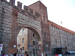
Nella cinta comunale si aprivano le seguenti porte: la Porta del Morbio (successivamente inclusa nel Castello di San Martino poi Castelvecchio), il romano Arco dei Gavi, che assunse la funzione di porta urbana col nome di Porta Sancti Zenonis, la Porta Orfana, la Porta della Bra (a un solo fornice), la Porta della Paglia, la Porta del Ponte Rofiolo. La nuova cinta terminava sull’Adige con una torre, detta della Paglia (distrutta nel 1624 a causa di un fulmine che fece scoppiare i barili di polveri là depositati). La cinta comunale-ezzeliniana fu successivamente rafforzata secondo il piano di difese urbane voluto da Alberto I della Scala (1283-1289), al quale è da attribuire la sopraelevazione della torre presso la Porta Rofiolana.
Nel 1325, la costruzione della cinta di Cangrande I della Scala a destra d’Adige ampliava considerevolmente le dimensioni della città e spostava la difesa principale ben oltre la vecchia cinta comunale. Tuttavia, anziché diminuire le potenzialità di quest’ultima, poneva le premesse per un’ulteriore articolazione difensiva all’interno della città. La conseguenza diretta fu la costruzione, all’estremità occidentale della cinta comunale, del formidabile caposaldo di Castel Vecchio (1354). Altri interventi scaligeri possono essere riferiti alla Rocchetta della Bra (dove poi sarà eretta la Gran Guardia) e alla Torre pentagona, rivolta all’esterno per la difesa della Porta.
In epoca viscontea (1387-1402) il sistema già predisposto dalle fortificazioni scaligere trovava un’ulteriore consolidamento con la formazione della Cittadella, l’ampio spazio quadrangolare compreso tra la cinta comunale-ezzeliniana, la cinta di Cangrande I (lungo la riva dell’Adige, a est, e lungo il fronte urbano meridionale), e delimitato a ovest dalla nuova muraglia con fosso antistante (lungo l’attuale corso Porta Nuova). Questo ampio spazio, destinato all’accampamento delle milizie e alle attrezzature logistiche, era in diretta comunicazione con Castel Vecchio attraverso la strada coperta esistente tra la cinta comunale e l’antemurale, lungo la quale potevano transitare milizie e artiglierie. Il tratto di cinta comunale che delimitava la Cittadella fu modificato per rivolgere la difesa verso l’esterno, rispetto allo spazio interno recintato.
La lenta trasformazione da mura a caserme
All’inizio del Quattrocento, in epoca veneta, nel medesimo tratto della Cittadella, lungo l’Adigetto, si stabiliscono nuove funzioni logistiche: nello spazio compreso tra la cinta comunale e il suo antemurale furono ricavati edifici per magazzini, ricoveri e opifici (arsanata). Queste destinazioni permanevano anche dopo lo smantellamento, negli anni 1533-1535, del tratto di muro lungo corso Porta Nuova, che apriva lo spazio della Cittadella agli usi civili. La parte più orientale fu riservata alle munizioni e alle polveri fino al 1624, anno in cui un fulmine colpì la Torre della Paglia, e causò moltissimi danni agli edifici circostanti; le polveri furono allora trasferite all’interno delle torri della cinta magistrale prossime a Castel San Felice. Gli altri edifici dell’arsanata erano usati come granai sino al 1605, quando furono liberati per essere sistemati a quartieri della guarnigione, stalle e scuderie. I granai con la casa del municionario furono riuniti a Castel Vecchio. Tuttavia permaneva la destinazione a granaio anche in tempi successivi.
Il fabbricato vicino alla Torre Pentagona, in corrispondenza della Gran Guardia, era destinato a Quartier Pubblico di Cavalleria. Nel 1703 fu necessario adibire a ospedale delle Milizie l’edificio centrale poiché non bastavano i locali dell’Ospedaletto Vecchio. Negli anni successivi, l’ospedale era sovradimensionato, e perciò era usato anche come caserma. All'esterno, sul fronte di via Pallone, era annessa una Cappellina dell’Ospedale delle Milizie.
In epoca veneta (secoli XV-XVIII), alle caserme del Pallone-Gran Guardia erano coordinati gli altri edifici militari situati nelle immediate vicinanze: le caserme dell’Adigetto, Tezone, della Cittadella, l’ospedaletto Vecchio. Il medesimo articolato insieme logistico del Pallone-Gran Guardia venne conservato anche in epoca absburgica (1814-1866) con diverse destinazioni, succedutesi nel tempo al variare del complessivo ordinamento militare del corpo di piazza.
Nell’anno 1798, durante la prima occupazione austriaca, è documentata la presenza di depositi della Provianda e degli Uffici della Direzione delle Fortificazioni, con l’annesso cantiere per le macchine e i materiali. Dal 1838-1840 gran parte dei fabbricati è destinato a caserma, tranne una parte adibita a deposito del treno d’artiglieria (Artillerie Fuhrwerkes Depot). In seguito ai lavori di sistemazione e adattamento l’intero complesso è destinato a caserma. Nella pianta di Verona del 1850, rielaborata per uso militare negli anni 1852-1853, sono registrate le cinque caserme di fanteria del pallone (A, B, C, D, E) con la capienza complessiva di 1483 uomini.Sotto l’Amministrazione Italiana, dopo il 1866, nelle Caserme del Pallone si insediò il VI Reggimento Alpini.
Il contenitore può ospitare Geocoin e Traveling Bug.
 The walls of Verona
The defensive system of the city on the right Adige referable to the centuries XII and XIII has two fences walls that follow the course of the Adigetto tracked with irregular and almost parallel. Over time they overlapped restorations and reconstructions on both walls, so that now you can only make assumptions about when and how they are constructed. The existence of a city wall along the Adigetto is documented in the first half of the twelfth century (1157); a second phase may be defined between 1239 (the year when a flood caused the collapse of the wall in two sections) and 1259; at this time of Ezzelino III da Romano she had the interest to keep in Verona a solid foundation for his army. The structure is then achieved to be considered as a solution accomplished: the system boundary-rampart-ditch itself as a kind of fortifications based on the concept of defense gradual.
It is to share the hypothesis that the excavation of the Adigetto is contemporary to the construction of the walls, and these have since been reinforced by a rampart with trend almost parallel, and partially rebuilt. It is plausible that the rampart has more immediately the process of urban transformation, as to be almost completely disappeared, while in the main belt are overlapped restoration, reconstruction, strengthening and transformation.
In the municipal boundary opened the following ports: the Port of Morbio (subsequently included in the Castle of San Martino then Castelvecchio), the Roman Arch of Gavi, which turned it into a port city with the name of Porta Sancti Zenonis, the Porta Orphan, the Porta della Bra (single arch), the Porta della Paglia, the Porta del Ponte Rofiolo. The new city on the Adige ended with a tower, called the Straw (destroyed in 1624 because of a lightning strike that sparked the barrels of powder deposited there). The municipal boundary-Ezzelino was subsequently reinforced according to the plan of urban defenses built by Alberto I della Scala (1283-1289), which was due the raising of the tower at the Port Rofiolana.
In 1325, the construction of the town of Can Grande della Scala right Adige expanded considerably the size of the city and the main defense moved well beyond the old city hall. However, instead of decreasing the potential of the latter, he laid the foundations for further joint defense within the city. The direct result was the construction of the western end of the town hall, the formidable stronghold of Castel Vecchio (1354). Other interventions Scala can be referred to the Rocchetta Bra (where it will be erected the Gran Guardia) and the Tower pentagona, facing outward to defend the port.
In Visconti era (1387-1402) the system already set up by the fortifications Scala was further consolidated with the formation of the Citadel, the large square space between the municipal boundary-Ezzelini, the city of Cangrande I (along the shore of ' Adige, east, and south along the urban front), and bounded on the west by the new wall with ditch in front (along the present course Porta Nuova). This large space for the camp of the militia and logistics equipment, was in direct communication with Castel Vecchio through the covered road between the city hall and the outer wall, along which they could pass militia and artillery. The stretch of the municipal boundary that marked the Citadel was modified to address the defense out, compared to the inner space enclosed.
The slow transformation from walls to barracks
At the beginning of the fifteenth century, during the Venetian, in the same section of the Citadel, along the Adigetto, we will establish new logistics functions: in the space between the city hall and its rampart were made buildings for warehouses, shelters and factories (arsanata) . These destinations persisted even after the dismantling, in the years 1533-1535, the stretch of wall along Corso Porta Nuova, which opened the space of the Citadel to civilian use. The eastern section was reserved for munitions and dust until 1624, when lightning struck the tower of the Straw, and caused a lot of damage to the surrounding buildings; The powders were then transferred into the towers of the city masterful next to Castel San Felice. The other buildings were used as granaries dell'arsanata until 1605, when they were released to be placed in areas of the garrison, stables and stables. The barns with the house of municionario were gathered at Castel Vecchio. However it persisted destination in the barn and also later.
The building near the Tower Pentagona, at the Gran Guardia, was intended to Quartier Public Cavalry. In 1703 it was necessary to use as a hospital of the Militia central building because there were not enough local dell'Ospedaletto Vecchio. In subsequent years, the hospital was oversized, and so it was used as a barracks. Outside, to the front of Via Pallone, he had an adjoining chapel of the Hospital of the Militia.
During the Venetian (XV-XVIII), the barracks of the Ball-Gran Guardia were coordinated other military buildings in the immediate vicinity: the barracks Adigetto, Tezone, the Citadel, the old hospice. The same complex network of logistics Ball-Gran Guardia was preserved even in times Habsburg (1814-1866) with different destinations, it occurred over time to changes in the overall military organization of the body of the square.
In 1798, during the first Austrian occupation, it is documented the presence of deposits of Provianda and the Offices of the Directorate of Fortifications, and the adjacent construction site for the machines and materials. From 1838-1840 most of the buildings is intended to barracks, except a part used as a train depot artillery (Artillerie Fuhrwerkes Depot). Following the premises and adapting the entire complex is intended to barracks. Plant in Verona in 1850, reworked for military use in the years 1852-1853, are recorded five infantry barracks of the ball (A, B, C, D, E) with the total capacity of 1,483 men.
Under the Italian Administration, after 1866, in the barracks of the ball he settled the VI Alpine Regiment. (Translated by Google Translator).
The container can accommodate Geocoin and Traveling Bug.
 Die Mauern von Verona
Das Verteidigungssystem der Stadt auf der rechten Adige beziehbar auf den Jahrhunderten XII und XIII verfügt über zwei Zäune Mauern, die den Verlauf der Adigetto folgen verfolgt mit unregelmäßigen und fast parallel. Im Laufe der Zeit überlappen Restaurationen und Rekonstruktionen an beiden Wänden, so dass jetzt können Sie nur Vermutungen, wann und wie sie aufgebaut sind zu machen. Die Existenz einer Stadtmauer entlang der Adigetto wird in der ersten Hälfte des zwölften Jahrhunderts (1157) dokumentiert; eine zweite Phase, zwischen 1239 festgelegt werden (das Jahr, als eine Flut verursacht den Zusammenbruch der Wand in zwei Abschnitte) und 1259; in dieser Zeit des Ezzelino III da Romano hatte sie das Interesse in Verona eine solide Grundlage für seine Armee zu halten. Als eine Art von Befestigungsanlagen auf der Grundlage des Konzepts der Verteidigung schrittweise die Systemgrenze-Wall-Graben selbst: Die Struktur wird dann erreicht werden, um in Betracht gezogen werden, wie eine Lösung erreicht.
Es ist die Hypothese, dass die Ausgrabung der Adigetto ist zeitgenössisch, um den Bau der Wände teilen, und diese haben seit dem von einem Wall mit Trend fast parallel und teilweise umgebaut verstärkt. Es ist plausibel, dass die Wall hat mehr sofort den Prozess der urbanen Transformation, um fast vollständig verschwunden, während im Hauptgürtel überlappen Wiederherstellung, den Wiederaufbau, die Stärkung und Verwandlung.
In der Gemeindegrenze eröffnet die folgenden Anschlüsse: der Hafen von Morbio, römischen Bogen von Gavi, die sie in eine Hafenstadt mit dem Namen Porta Sancti Zenonis, der Porta Orphan drehte (später in der Burg von San Martino dann Castel enthalten) die Porta della Bra (einzigen Bogen), der Porta della Paglia, die Porta del Ponte Rofiolo. Die neue Stadt an der Etsch endete mit einem Turm, genannt Straw (1624 aufgrund eines Blitzschlags, der die Pulverfässer dort abgelegt löste zerstört). Die Gemeindegrenze-Ezzelino wurde anschließend nach dem Plan des städtischen Verteidigungs von Alberto I della Scala (1283-1289), der das Anheben der Turm im Hafen Rofiolana wegen gebaut wurde verstärkt.
In 1325, der Bau der Stadt Can Grande della Scala rechten Adige erweitert erheblich die Größe der Stadt und der Hauptverteidigung bewegt weit über dem alten Rathaus. Anstatt jedoch die Verringerung der potentiellen der letzteren, legte er den Grundstein für weitere gemeinsame Verteidigung in der Stadt. Die unmittelbare Folge war der Bau der westlichen Ende des Rathauses, der gewaltigen Festung Castel Vecchio (1354). Andere Interventionen Scala können zur Rocchetta Bra (wo sie aufgestellt werden die Gran Guardia) und dem Tower pentagona bezeichnet werden, nach außen, um den Hafen zu verteidigen.
In Visconti-Ära (1387-1402) das System bereits durch die Befestigungsanlagen Scala wurde weiter mit der Bildung der Zitadelle, dem großen Platz Raum zwischen der Gemeindegrenze-Ezzelini, der Stadt Cangrande I konsolidiert entlang der Ufer des 'gesetzt ( Adige, Osten und Süden entlang der städtischen Front) und im Westen an die neue Mauer mit Graben vor (entlang der gegenwärtigen Kurs Porta Nuova) begrenzt ist. Diese großen Raum für das Lager der Milizen und Logistik-Ausrüstung war in direkter Verbindung mit Castel Vecchio über den überdachten Straße zwischen dem Rathaus und der Außenwand, entlang derer sie Miliz und Artillerie passieren konnte. Die Strecke von der Gemeindegrenze, die die Zitadelle markiert wurde modifiziert, um die Verteidigung Adresse aus, im Vergleich zu dem Innenraum eingeschlossen.
Der langsame Übergang von Wänden in die Kaserne
Zu Beginn des fünfzehnten Jahrhunderts, während der venezianischen, in dem gleichen Abschnitt der Zitadelle, entlang der Adigetto, werden wir neue Logistikfunktionen zu etablieren: in den Raum zwischen dem Rathaus und seine Wall gemacht wurden Gebäude für Lagerhäuser, Hütten und Fabriken (arsanata) . Diese Ziele bestand auch nach der Demontage, in den Jahren 1533-1535, die Ausdehnung der Wand entlang Corso Porta Nuova, die den Raum der Zitadelle auf die zivile Nutzung geöffnet. Der östliche Teil wurde für Munition und Staub, bis 1624, als ein Blitz den Turm der Straw, und verursacht eine Menge Schaden an den umliegenden Gebäuden vorbehalten; Die Pulver wurden dann in die Türme der Stadt meister neben Castel San Felice übertragen. Die anderen Gebäude wurden als Kornspeicher dell'arsanata, bis 1605, wenn sie freigegeben wurden, in Bereichen der Garnison, Stallungen und Pferdestall platziert werden verwendet. Die Scheunen mit dem Hause municionario wurden bei Castel Vecchio versammelt. Doch es blieb Ziel in der Scheune und auch später.
Das Gebäude in der Nähe des Tower pentagona, an der Gran Guardia, wurde Quartier Öffentliche Cavalry gedacht. Im Jahr 1703 war es notwendig, als Krankenhaus der Miliz Zentralgebäude zu verwenden, weil es nicht genug lokale dell'Ospedaletto Vecchio. In den folgenden Jahren war das Krankenhaus überdimensioniert, und so ist es als Kaserne genutzt wurde. Draußen, auf der Vorderseite der Via Pallone, hatte er einen angrenzenden Kapelle des Krankenhauses von der Miliz.
Die Kaserne Adigetto, Tezone, die Zitadelle, das alte Hospiz: Während der venezianischen (XV-XVIII) wurden die Baracken des Kugel Gran Guardia andere militärische Gebäude in unmittelbarer Nähe koordiniert. Das gleiche komplexe Netzwerk der Logistik Kugel Gran Guardia wurde auch in Zeiten Habsburg (1814-1866) mit verschiedenen Zielen erhalten, fiel im Laufe der Zeit zu Veränderungen der allgemeinen militärischen Organisation des Körpers auf den Platz.
Im Jahr 1798, während der ersten österreichischen Besetzung, wird das Vorhandensein von Ablagerungen von Provianda und die Büros der Direktion für Befestigungsanlagen, und die benachbarten Baustelle für die Maschinen und Materialien dokumentiert. Von 1838-1840 die meisten Gebäude wird die Kaserne soll, mit Ausnahme eines Teils als ein Eisenbahndepot Artillerie (Artillerie Fuhrwerkes Depot) verwendet. Im Anschluss an die Räumlichkeiten und die Anpassung der gesamte Komplex wird in die Kaserne soll. Plant in Verona im Jahre 1850, die für militärische Zwecke in den Jahren 1852 bis 1853 überarbeitet werden aufgezeichnet fünf Infanteriekaserne der Kugel (A, B, C, D, E) mit einer Gesamtkapazität von 1.483 Männern.
Unter der italienischen Verwaltung, nach 1866, in der Kaserne der Ball ließ er sich die Alpine Regiment VI. (Übersetzt von Google Translator).
Der Behälter kann Geocoin und Reisen Bug unterzubringen.