To the West of the Cuillin Hills lies the valley called Coire Na Creiche this is where the famous Fairy Pools can be found. An easy walk that should take you about an hour. The Fairy Pools is within Cuillins SSSI and Special Protection Area (for golden eagle), so to ensure the continued support of the land owners please treat the area with respect and notify me immediately via my profile email of any issues at the site.
The Geology of the Cuillin
The Cuillin are considered to be the most dramatic mountain range in Britain. From the tall, dark, jagged peaks of the Black Cuillin to the smoother, more rounded summits of the Red Hills, climbers and hill walkers of all levels of skill and experience are drawn to the majesty of the Cuillin all year round.
The Cuillin are one of the finest examples of a heavily glaciated, early Palaeogene volcanic centre in the world, which has been eroded by the wind and rain over the past 1 million years. What we see today are the bowels and inner plumbing of an ancient volcano, and Skye has become recognised as an area of great importance to both geologists and volcanologists, as to understand how volcanoes are formed, they study extinct volcanoes and regions of previous volcanic activity.
Compared to other parts of Skye, the Cuillin can be seen as relatively young. Their formation began somewhere between 50-70 million years ago, during a period of massive volcanic upheaval as North America pulled away from Europe and the Atlantic Ocean widened, forming a chain of volcanoes down the west side of the Highlands.
The lava that formed the Cuillin was not poured out by a large volcano, such as Mount Etna, but welled up from innumerable fissures in the earth’s crust. As the lava cooled rapidly on or near the surface, it became Basalt, a fine texture rock which is smooth and slippery, particularly when wet. Overtime the lava flow changed and became injected with Gabbro, a dense, rough grey or brown crystalline rock which is chemically equivalent to Basalt. Gabbro is formed through the slow cooling of magma beneath the earth’s surface into a dense, greenish or dark-coloured, coarse-grained rock.
It is this process that formed the Black Cuillin, which is predominately composed of Gabbro, interspersed with other rock, including Peridotite and Basalt, with the later forming the Inaccessible Pinnacle on Sgùrr Dearg and much of the summit of Sgùrr Alasdair. The Red Hills were formed from the molten mass of Basalt and Gabbro coming into contact with the lower crust of the Earth. The heat caused the lower crust to melt, injected the lava with further elements, which formed the red/pink tinged granite that gives the region its name.
However, what we see today is far different to what was visible when the magma/lava first cooled. Firstly, much of the rock when it first solidified was under the lava field which covered much of the Isle of Skye. Through geological uplift, intense weathering and erosion during the Late Tertiary period, between 38 and 1.6 million years ago, removed a significant proportion of the lava field and exhumed the subvolcanic intrusions, which formed what we now call the Cuillin Range.
It was another natural phenomenon that changed what first appeared in the late tertiary period, to what we mainly see today, that of glaciation. Technically we currently live in an Ice Age as we have polar ice caps, but during the last period of widespread glaciation (between 2.6 million and 11500 years ago), many, if not all of the 30 plus peaks of the Cuillin Range were covered in ice and frost. This period was not a continued period of glaciation, but glacial periods were interspersed with periods of warm weather. The periods of ice, followed by the effects of the melting ice had an effect on the rock of the Cuillin that are still visible. Scratch marks (striae), ice-smoothed rocks (roches moutonnées), and rocks carried from their original outcrops by ice (glacial erratics) are easily visible, as were caused by the movement of the ice itself during the period. The ice also made dramatic changes to the Cuillin, with the formation needle sharp arêtes between corrie glaciers, and also the trough and basin in which Loch Coruisk sits was carved out due to the ice. The frost has and can continue to shatter rocks from the cliffs and pinnacles of the Cuillin, and this led to the formation of many scree slopes, the most famous of which is Great Stone Shute, which is over 450 metres high and a necessary climb for those wishing to climb Sgùrr Alasdair from Coire Lagan.
It is not only glacial erosion that has affected the shape of the Cuillin, the wind and rain have also changed how Cuillin look. The obvious difference between the Black Cuillin and the Red Hills is their shape and this has been greatly affected by erosion. On the Black Cuillin, the fine-grained basalt has eroded at a far greater pace than the Gabbro, with this irregular erosion being responsible for the formation of some of the deep corries and gullies, along with slots, pinnacle and ‘bad steps’ that are the delight or despair of the modern day hill goer. The granite-based Red Hills have eroded at a far more steady pace, and this has led to their smoother, rounded shape, but both the Black and Red Cuillin have slopes of scree that were originally formed during the ice age, but have been effected by weathering.
As you make your way from the car park you will need to visit a number of waypoints to qualify for this Earthcache. Email me the answers and please do not include your answers in your logs.
Waypoint 1
1. How many stepping stones?
Waypoint 2
2. Here you will find two pools which are joined together by a large underwater opening under a natural arch. The rocks here can be slippery, be careful at the edge. Estimate the the thickness of the natural arch between the 2 pools.
Waypoint 3
You will see a distinct line of rock running at an angle down the river, if you look down into the hole (rock cut basin) downstream you will also see this same line of rock.
3. Describe this layer, what rock do you think it is, and estimate its thickness.
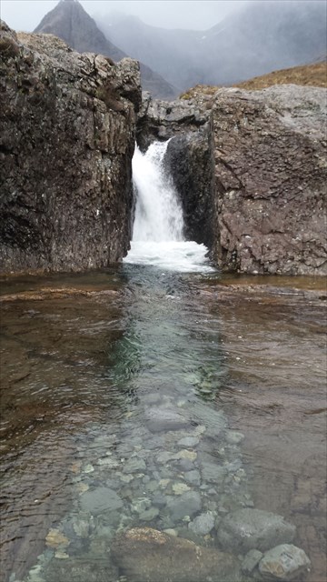
Waypoint 4
4. Estimate the height of the waterfall
Waypoint 5
You may get wet feet getting to the actual co-ordinates but not necessary if the river is in full flow. Here you will see a pool with a distinct lighter line at the base of the pool. (See photo)
5. Explain how you think this line was formed.
It would be great to see plenty of photos of your visit to The Fairy Pools
Many thanks to The Macleod Estates and Scottish Natural Heritage for allowing this Earthcache to be published.