Little Bridges #500 Sturt Bridge EarthCache
Little Bridges #500 Sturt Bridge
-
Difficulty:
-

-
Terrain:
-
Size:  (other)
Please note Use of geocaching.com services is subject to the terms and conditions
in our disclaimer.
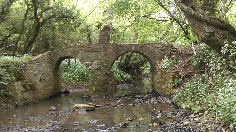
Sturt bridge is a packhorse bridge, probably late mediaeval or C16/C17.
Rubble and Cotswold Stone bridge of two arches, the west one is slightly pointed; central cutwaters, no parapet.
It spans the Little Avon river.
The Cotswolds is an area in south central England containing the Cotswold Hills, a range of rolling hills which rise from the meadows of the upper Thames to an escarpment, known as the Cotswold Edge, above the Severn Valley and Evesham Vale.
The area is defined by the bedrock of limestone that creates a type of grassland habitat rare in the U.K. and that is quarried for the golden coloured Cotswold stone.
Oolite (egg stone) is a sedimentary rock formed from ooids, spherical grains composed of concentric layers. The name derives from the Hellenic word òoion for egg. Strictly, oolites consist of ooids of diameter 0.25–2 mm; rocks composed of ooids larger than 2 mm are called pisolites.
Ooids are most commonly composed of calcium carbonate (calcite or aragonite), but can be composed of phosphate, chert, dolomite or iron minerals, including hematite.
They are usually formed in warm, supersaturated, shallow, highly agitated marine water intertidal environments, though some are formed in inland lakes. The mechanism of formation starts with a small fragment of sediment acting as a 'seed', e.g. a piece of a shell. Strong intertidal currents wash the 'seeds' around on the seabed, where they accumulate layers of chemically precipitated calcite from the supersaturated water. The oolites are commonly found in large current bedding structures that resemble sand dunes. The size of the oolite reflects the time they have had exposed to the water before they were covered with later sediment.
The Cotswolds are roughly 25 miles (40 km) across and 90 miles (145 km) long, stretching south-west from just south of Stratford-upon-Avon to just south of Bath. It lies across the boundaries of several English counties; mainly Gloucestershire and Oxfordshire, but also parts of Wiltshire, Somerset, Worcestershire and Warwickshire.
The highest point of the region is Cleeve Hill at 1,083 ft (330 m), just to the north of Cheltenham.
The northern and western edges of the Cotswolds are marked by steep escarpments down to the Severn valley and the Warwickshire Avon. This feature, known as the Cotswold escarpment, or sometimes the Cotswold Edge, is a result of the uplifting (tilting) of the limestone layer, exposing its broken edge. This is a cuesta, in geological terms. The dip slope is to the southeast. On the eastern boundary lies the city of Oxford and on the west is Stroud. To the southeast, the upper reaches of the Thames Valley and towns such as Lechlade, Tetbury and Fairford are often considered to mark the limit of this region. To the south the Cotswolds, with the characteristic uplift of the Cotswold Edge, reach beyond Bath and towns such as Chipping Sodbury and Marshfield share elements of Cotswold character.
The area is characterised by attractive small towns and villages built of the underlying Cotswold stone (a yellow oolitic limestone).
In the Middle Ages the wool trade made the Cotswolds prosperous. Some of this money was put into the building of churches so the area has a number of large and handsome Cotswold stone "wool churches".
Cotswold stone is a yellow oolitic limestone. This limestone is rich in fossils, particularly of fossilised sea urchins.
When weathered, the colour of buildings made or faced with this stone is often described as honey or golden.
The stone varies in colour from north to south, being honey coloured in the north and north east of the region, as shown in Cotswold villages such as Stanton and Broadway; golden coloured in the central and southern areas, as shown in Dursley and Cirencester; and pearly white in Bath.
The rock outcrops at places on the Cotswold Edge; small quarries are common.
To log this earthcache complete the following:
Question 1: Describe the appearance of the rocks. Can you explain how this limestone was formed ?(based on a little research)
Question 2:To which geological period does oolite limestone belong?
Question 3:Observe the stones for fossils, describe what you find.
Question 4:Cotswold stone varies in color from the North to the South. What color stone is used to build the bridge?
Optional, you may like to post a photo of yourself at the location.
Please email me via my profile, do not post your answers in your logs!

The Little Bridges series was started by Stanthews in 2009 to highlight small footbridges in remote parts of Wiltshire. Since then the series has been expanded by others all over the country and starting to spread fast, Damian from Winter Foxes has created and updates a list of cachers who has found 10 or more little bridges and can be found here, if you would like to add to the series, please contact Stan here and he will give you a number for your bridge, to qualify, the bridge must be a foot bridge too small for vehicles, please make sure your title exactly matches “Little Bridges # xx then name” including spaces so it will get picked up and added to Damian’s list.
Additional Hints
(Decrypt)
Cyrnfr rznvy hf gur nafjref