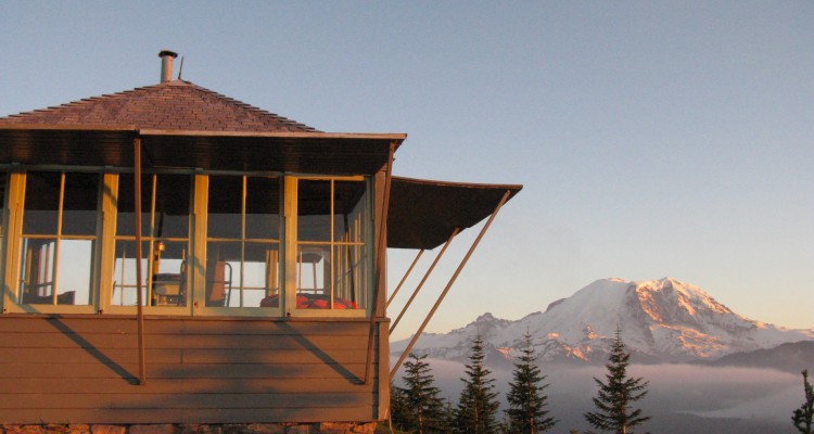
Suntop is one of the few remaining fire lookouts in the Mount Rainier area, and one of the best preserved - a relic of the days when a manned fire lookout was the only way to watch for forest fires. The restored lookout was built in 1934 and is listed in the National Register of Historic Places.
The fire lookout is perched at 5,300 feet on an extinct volcano in the Mt. Baker-Snoqualmie National Forest , with incredible 360-degree views. Mount Rainier is 10 miles to the south, and on a clear day you can also see the central Cascades, Olympic Mountains, and Mount Baker 150 miles to the north. A breathtaking 3,000-foot drop leads down to the White River on the east with Huckleberry Creek on the west.
Suntop has a nice picnic area, and is popular with families, hikers, mountain bikers, and (in winter) snowshoers and cross-country skiers. In July and August, the lookout is often manned by volunteers, who can give you a tour and answer questions.
There are two terrain ratings for this cache:
- If the gate is open (in summer), you can drive all the way to the summit and the lookout with a short walk of a couple hundred yards to the cache location. So I gave it a 1.5-star Terrain rating.
- If the gate is closed, then you can either walk up the road about .6 miles to the lookout, or you can take the shorter but steeper trail to the top. In winter, you'll need snowshoes or skis. Either way, it's about a 3-star Terrain rating.
DO NOT attempt to get this cache by climbing up the steep hill from the road. Park in the designated parking area and follow the trail from the lookout to the cache location.
To reach Suntop lookout: Take Hwy 410 to Greenwater. A few miles south of town, there's a rest stop area, and just south of that is Forest Service Road 73. Take FS 73 about 1.25 miles to FS 7315, which takes you to Suntop in 5.5 miles. The last half mile to the top is a narrow road with steep drop-offs, so drive slowly and be careful. All the Forest Service roads are gravel and a bit washboardy, but you don't need a 4X4 or high-clearance vehicle; just about any car can make it to the top.
A Northwest Forest Pass is required to park at the lookout and picnic area.
2016 was the 100th anniversary of the National Park Service, and to celebrate, Visit Rainier and WSGA hosted the Visit Rainier Centennial GeoTour - 100 caches placed in and around Mount Rainier National Park. The geocaches highlighted the rich history, scenic wonders, quaint communities, and hidden gems of the Rainier region. Participants received geocoin and pathtag prizes for finding all the caches.

