Marine Drive Turbidites EarthCache
-
Difficulty:
-

-
Terrain:
-
Size:  (other)
Please note Use of geocaching.com services is subject to the terms and conditions
in our disclaimer.
The above coordinates will bring you to an area of exposed rock along Marine Drive. The rocks in this area formed over 410 million years ago at the bottom of a steep undersea slope. This slope linked the shallow sea bed (continental shelf) off the coast of an ancient microcontinent called Avelonia, with the much deeper ocean bottom (abyssal plain) of the Iapetus Ocean.
TURBIDITE FLOWS
The process that formed these rocks began with sediment (deposited by rivers, coastal erosion and even animal remains) collecting at the top of the slope over a period of several hundred years.
Eventually, tectonic activity such as earthquakes would dislodge the sediment, causing it to flow down the slope (a kind of underwater avalanche called a turbidite flow) Once it reached the ocean floor, the sediment would spread out and settle, creating a sedimentary structure known as a submarine fan. This process would be repeated, resulting in layers of sediment that eventually formed rocks. (Turbidite flows still occur today in coastal earthquake zones around the world) Then, about 400 million years ago, movement of the Earth’s tectonic plates caused the Iapetus ocean to close and as the land masses collided, the rocks were lifted, folded and fractured to create the amazing folded structures you can see today all along Marine Drive.
The Niarbyl Earthcache by Twoofnine gives a lot more information about the geology of this period.
I chose this particular spot, however, as it’s here you can still see evidence of the original turbidite flows in the form of Sole Marks.
SOLE MARKS
Sole marks are a key indicator of turbidite flows as they form in areas where long periods (100s of years) of calm conditions are broken by sudden high energy currents. During the calm periods, fine sediment can settle out to create a layer of mud. When the coarser grained sand or silt of a turbidite flow travels over this mud, it carves grooves in this fine mud layer which it then fills in (in the same way you might make a plaster cast of a footprint). Once the sediment forms a rock, these casts are hidden away inside but, as has happened here, they can become exposed when tectonic activity brings the rocks to the surface and the softer rocks (formed from the mud deposited in the calm periods) are eroded. The casts are now visible on the surface of the harder rock as lumps and bumps - called Sole Marks as the surface they are on was originally the bottom of the turbidite flow. There are a number of different types of sole marks. formed in different ways:
Flute/Scour Casts - form in grooves and pits eroded in the softer layer.
Skip Marks - regularly spaced marks caused by an object such as a stick or stone being bounced along the sea bed by the flow.
Prod Marks - caused by objects digging into the surface.
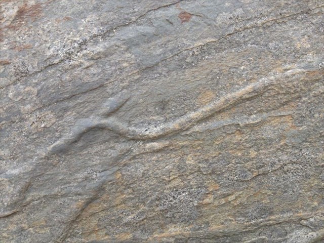
Roll Marks - long linear marks caused by an object being dragged or rolled along by the flow. Some marks can even form in animal tracks/burrows.
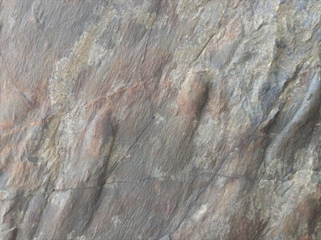
FLUTE CASTS
ROLL MARK or ANIMAL TRACK?
Flute Cast Sole Marks are important as they not only tell us about the conditions in which the sediment was deposited but they also act as paleocurrent indicators - i.e they can tell us the direction of the ancient flows that created them. The flute marks you'll see have a rounded, well defined raised end that tapers down to the surface. The well defined rounded end points in the direction that the flow came from.

They are also useful way-up indicators (as they form on the bottom of a sedimentary layer) allowing us to work out the relative ages of the rocks.
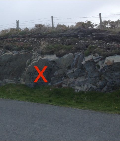
To claim this Earthcache, you need to find the sole marks at the given location (marked with the red X in the photo) and email me the answers some simple questions.
1. What is the orientation of the flute casts, i.e. in which direction was the flow that created them travelling?
2. Are the rocks to the left older or younger than the rocks with the flute casts? How do you know?
3. A few metres to left is a layer of rock, highly fractured by the events surrounding the closing of the Iapetus Ocean. The fractures create a repeated pattern consisting of a simple geometric shape - what shape?
If you want to, feel free to post photos of any interesting sole marks you can spot but please make sure they don't give away any of the answers to the questions.
Happy hunting!!
Additional Hints
(No hints available.)