A Brief History
A growing number of visitors came to Matlock Bath during the 18th and early 19th centuries to sample the thermal waters, as first the French Revolution and then the Napoleonic Wars raged in Europe. Then in 1849 the railway arrived, bringing day trippers. This growing visitor pressure prompted the High Tor Grounds to be created and opened to the public by their owner Peter Arkwright (grandson of Sir Richard Arkwright, founder of the mills at nearby Cromford).
New walks and a carriage ride to the summit were created. Two abandoned lead mines - Fern and Roman 'Caves' - were opened as official visitor attractions. These have now been closed due to modern health and safety. High Tor continued to be a tourist attraction when in 1879 the Matlock and High Tor Recreation Company leased the grounds from the Arkwright family and reopened the grounds in 1880 complete with new entrance from Matlock Bath and a refreshment building on the summit.
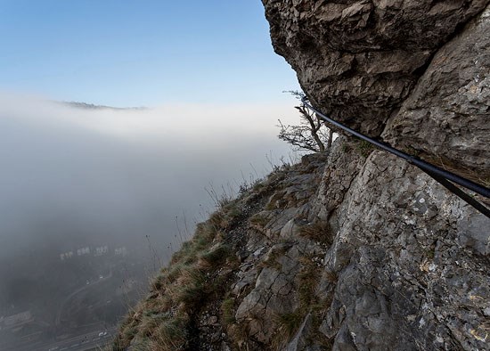
One of the key attractions was a perilous walk along the front of a spectacular limestone reef. The Victorian’s seemed to enjoy opening tourist access to previously inaccessible areas and this is a fine example. A very narrow path hugs the front of the limestone reef and an iron handrail was fixed as the only means to ensure you don’t fall down the vertical cliff face into the gorge. A 2008 renewal of the High Tor grounds saw a one way system installed (by means of two signs) and otherwise, the path remains open to all. To log this earthcache, you will need to take a walk along Giddy Edge and answer the questions at the bottom of the listing. I would not recommend visiting in wind, snow, ice or even rain and anyone who suffers from vertigo would be advised to avoid this earthcache as there is a sheer drop directly off the side of the path. The path is considered safe by the authorities, however, it is hazardous and you visit at your own risk.
Geology
High Tor is well known as a fine example of a Carboniferous reef - known more precisely as a carbonate mud mound. This splendid structure is cleanly exposed in the vertical limestone cliff above the east bank of the Derwent Gorge between Matlock and Cromford. High Tor forms the highest part of the cliff and to see the scale of it, you are best viewing it from the opposite side of the valley, as seen in the below photograph.
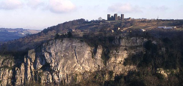
The main cliff is made up of bedded limestones of the Monsal Dale and overlying Eyam Limestone Formations of Brigantian age that enclose a lens-shaped mass of pale unbedded limestone (see Fig. 2). The Great Rake, a mineralised fault previously worked for fluorspar, cuts the southern edge of High Tor and is marked by a line of old mine workings. High Tor Rake emerges on to cliff face immediately to the north of the carbonate mud mound. The ground behind High Tor is formed by late Brigantian and early Namurian shale, with Riber Castle, the dramatic building on the skyline behind you is built on the escarpment of Ashover Grit.
 Fig 2: The internal structure of the carbonate mud mound, sketched from the same angle as the previous photograph. The mound core initially grew vertically (1) followed by a phase of lateral growth (2).
The lens-shaped mass of pale unbedded limestone at High Tor is an excellent example of a carbonate mud mound – this is the main type of reef found in limestones of Carboniferous age around the world. Reefs were constructed by communities of creatures and organisms that formed a rigid structure on the sea floor supported by their calcareous skeletons. To put this into perspective, modern reefs are constructed by corals, sponges and calcareous algae that grow in tropical conditions found around Florida, the Red Sea and the Great Barrier Reef of Autralia.
Reefs were built by different communities as organisms evolved through geological time; corals, sponges, bivalved molluscs and calcareous algae were responsible for many Mesozoic and Tertiary reefs, while corals and stromatoporoids were important reef-builders during the Palaeozoic and blue-green algal reefs occur in late Pre-Cambrian carbonate successions. However, the Carboniferous was an unusual period in geological history because no dominant reef-building community is present and it is not known how carbonate mud mounds, including the one at High Tor, grew.
The lens of unbedded limestone represents the core of a dome-like mound that probably stood some 10-20 m above the surrounding sea floor at its maximum development. It is composed almost entirely of carbonate mud; fossils are scarce but include brachiopods, fenestrate (fan-like) bryozoans, bivalves and crinoids. The brachiopods and bivalves often occur as clusters while the fenestrate bryozoans and crinoids are scattered through the mound core. Unlike modern reefs, no organisms with large calcareous skeletons capable of constructing a supporting framework are present.
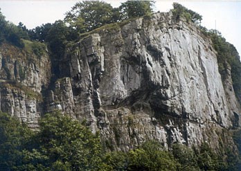 The unbedded lens of the carbonate mud mound on the right passes left into bedded limestones of the mound flank and intermound areas. The shadowed cleft in the centre is High Tor Rake, a mineralised fault that emerges from behind the cliff.
The main mound grew by the combination of smaller mounds that can be seen around the base of the mound core (again, see Fig. 2). Bedding planes that dip away from the mound core become more prominent towards the margins of the mound core. These are the mound flank beds that represent the original surface of the carbonate mud mound, with depositional slopes that may have been as steep as 30-40 o. Like the mound core, the mound flank beds are composed mainly of carbonate mud, but with fewer brachiopods and more abundant crinoids.
Questions to Answer (please send via my profile – please ideally use the email facility rather than the new messager.
The given co-ordinates will take you close to the start Giddy Edge path at High Tor but for safety reasons they will not take you right to the cliff edge, you should follow the paths and signs the last few feet.
- Take an elevation reading at the entrance to Giddy Edge. Estimate the distance to the river Derwent below (or take another reading at the river when you descend later)
- Estimate the height of the limestone reef from the Giddy Edge path to its highest point above you.
- Consider the path as you walk along it. Do you think the route of the path is entirely natural or have the Victorian’s made any alterations to the rock to make their path possible? Please give specific examples if relevant.
- Having read the information and studied Fig. 2, please take a close look at the reef as you walk along Giddy Edge. Please comment on what you see in the mud mound – shapes, textures and look out for fossils. Can you spot any bedding planes or sloped flank beds in the rock? Include photographs of any interesting features with your log if you wish.
- Finally, take a look at the Derwent Gorge below you. Do you think it is a V shaped valley (therefore the valley has been shaped by the river Derwent) or a U shaped valley, (therefore formed glacially)?
A photograph of you or your GPSr on or near Giddy Edge would be good further proof of your visit to this dramatic location (optional). Do not take any unnecessary risks either with your photography or at any other time during your visit. Giddy Edge is potentially a dangerous path. You visit this location at your own risk and you should undertake your own assessment of the risks before walking Giddy Edge. A one way system operates for obvious safety reasons, please obey it. Please send in your answers at the same time as submitting your log or soon afterwards. If your answers are not received within a reasonable time you will be contacted and your log may be deleted.
Please note, High Tor is an SSSI, this designation means it contains scientifically significant features. Many thanks to Natural England for granting permission for this earthcache, they are happy it's completion should not in any way impact the area. However, please respect the area and do not interfere with the rocks or plantlife anywhere on High Tor. Many thanks for your consideration and please enjoy your visit.