Glacial stages existed during the last 2 .5 million years while the last major glacial advance in the Rocky Mountains started about 25,000 years ago and referred to as the Fraser Glaciation. The main ice centre was in central BC where the ice sheet was over 1 kilometer thick and the glacier flowed in all directions. A glacier flowed southward through this valley during the last ice age, advancing as far as Polson, Montana (about 90 miles from Eureka at the USA/Canada border). It retreated northward during the warming and by 10,000 years ago the valleys of southern BC were ice free.
Evidence of isostatic tilting is absent suggesting uniform ice thickness and thinning; which pattern is different from other areas of southern BC.
Meltwater began to pond at the toe of the receding trunk of the valley glacier. At the north end of the lake a dam formed from the retreating Trench and Beaver glaciers and the southern end by glacial till, gravel and an out crop bedrock between Canal Flats and Skookumchuk. Melt water from these valley glaciers and from the bordering rivers and creeks that entered the ponding water gradually grew until it filled the Rocky Mountain Trench to form Glacial Lake Invermere. The Trench, which runs north/south is sandwiched between the steep slopes of the Rocky Mountains and the Purcell/Selkirks in the west.
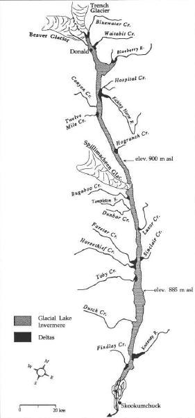
Map showing major rivers & creeks flowing into Lake Invermere and related deltas
This glacial lake ended its existence prior to 10,000 BP. It overflowed to the south from its formation until the end of its existence when the southern plug was broken. Drainage is thought to have been rapid based on a relative lack of terraces south of the plug. At its peak, the depth of the lake in the south, at Canal Flats, was estimated at 90 m versus 110m in the north at Donald. Other than the Columbia and Windermere Lakes and the extensive wetlands of the Columbia River, there are no large bodies of water left. These current lakes have depths averaging only of 4.5 m.
Both sides of the valley have glaciolacustrine terraces interspersed with deltas and gravel fans from the entry pools of major tributaries. These deltas give evidence of the maximum lake levels. There is a lack of terraces north of Spillmacheen.
There is evidence that in the early to middle phase of the lake, there were actually 2 lakes divided at Spillmacheen due to a glacier dam formed by a glacial ice tongue and debris. The existence of Jubilee Mountain, an outcrop in the Trench, contributed to this plug. The northern lake is more recent and was estimated to be 900 m above sea level, versus the older southern lake at 885 m above sea level. After the lobe melted the level of the lake dropped rapidly and formed a continuous lake at 835 m before final drainage.
 </>
</>
Diagram showing plug
The almost continuous series of deltas at 835m along the length of the lake support the evidence that once the Spillmacheen blockage was breached the two lakes coalesced into one at this lower elevation. The current Windermere and Columbia lakes are at 799 – 808 m respectively.

Diagram showing glaciolacustrine deposits and deltas
Ground zero for this Earthcache is a hill top overlooking the eastern side of Columbia Lake just north of Canal Flats.

Glacialacustrine deposits on south side of Columbia Lake
The Kootenay River comes within 1.5 K from the Columbia Lake at Canal Flats and is only separated by soft material that is elevated from the waters, less than 10 feet is some areas. This delta formed when the Kootenay River flowed into Glacial Lake Invermere. The Kootenay River normally flows south from Canal Flats but there is evidence that the Kootenay has flowed into the Columbia Lake on at least 2 occasions subsequent to the drainage of Glacial Lake Invermere. There have been suggestions that the glacial ice from the Kootenay River valley created the southern dam however the Findlay Creek delta is south of Canal Flats.
The fact that the Kootenay flows south is confirmation that the first dam to breach was the one in the south. At Canal Flats the floor of the Rocky Mountain Trench floor is separated, as a result of faulting, so that one side tips downhill southward and at the same point tips downhill northward. Thus the Kootenay River flows south to cross the US border and the Columbia flows northward.
As an aside, Columbia Lake became the headwaters of the Columbia River which was named by Capt. Robert Gray in 1792 after his vessel the Columbia Rediviva. After some difficulty navigating the mouth of the river he went upstream about 12-15 miles and this adventure was used as the claim by the United States for all of the land of the Pacific Northwest.
Acknowledgements to: B.C. Pearce (Geological Field Guide to The Southern Rocky Mountain Trench; E Swanson, College of the Rockies; O. Sawicki & D. Smith University of Calgary; Wikipedia.
To log this Earthcache, please email the owner with the following: a) Why can the Kootenay glacier not be the southern plug? b) Describe the difference in the elevation changes that exist between the area from Canal Flats north and south c) Why did the lake disappear? d) What is the biggest effect of the drainage?
| I have earned GSA's highest level: |
 |