自然豊かな奥日光、中禅寺湖の流出口に、高さ97mの滝があります。岸壁を水しぶきをあげて一気に落水する豪快さと、自然が作り出す華麗な造形美の両方をあわせ持つ素晴らしい名瀑です。
日本三大名瀑、日本地質100選に選定されています。
周辺には中禅寺湖、男体山があり、"火の国日本"の地質学的特徴を学ぶことができます。
There is this waterfall in the outlet of Lake Chuzenji of natural rich Oku-Nikko. The height of the waterfall is 97 meters. It is the daring, beautiful splendid waterfall which nature creates. Because this waterfall is the natural resource which is precious geologically in Japan, it is appointed to 100 selections of Japanese geological features and Japan's three biggest waterfall. There are Lake Chuzenji, Mount Nantai in the outskirts and can learn a geologic characteristic of "Fire country Japan ".
中禅寺湖、華厳滝はどのようにして、現在の姿になったのでしょうか?
この特徴的な地形は激しい火山活動と、豊富な水の流れによって造り出されました。
How would Lake Chuzenji, Kegon Waterfall become the current figure? This characteristic topography was created by intense volcanic activity and a flow of abundant water.
①男体山誕生以前

昔の大谷川は今の華厳渓谷よりも北側にあり、外山付近から東に向かって流れていました。
Before Mount Nantai birth
There was the old river in the north side than present Kegon Valley and drifted towards the east from the Toyama neighborhood.
②約2万年前
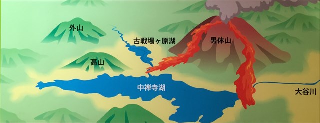
男体山の火山活動が始まり、その溶岩流(男体火山主活動期溶岩等)にせき止められて、中禅寺湖、古戦場ケ原湖ができました。そして中禅寺湖の水位が上がり溢れだし、華厳滝の原型がつくられました。
About 20,000 years ago
Volcanic activity of Mount Nantai began, and it was dammed up by the lava flow, and Lake Chuzenji were made. And water level of Lake Chuzenji rose and overflowed, and a model of Kegon Waterfall was made.
③約1万年前
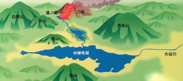
男体山が活動を再開し、大量の軽石が噴出する激しい火山活動によって、古戦場ケ原湖が埋められ次第に湿原へとなっていきました。
About 10,000 years ago
Mount Nantai reopened activity and an old lake was filled by the intense volcanic activity that a large quantity of pumice spouted out and gradually became the damp plain.
④現在
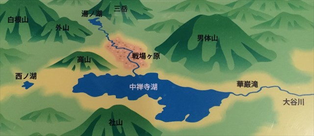
土砂や枯れた植物(砂礫層、崖錐層、湿地堆積層)が積もり、長い年月をかけて侵食を繰り返し800メートル程後退して、今の華厳滝となりました。
At present
Long time and repeated erosion, and the earth and sand and a plant (gravel, talus layer, the damp ground sedimentation layer) which died retreated approximately 800 meters, and it was with present Kegon Waterfall.
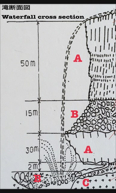
展望台から滝周辺を観察してみましょう。
華厳滝周辺は下記岩石によって構成されています。
Let's observe the waterfall outskirts from an observatory.
Around Kegon Waterfall is constructed by the following rock.
熔結凝灰岩
部分的または完全に熔結し硬化した凝灰岩で、約6500万年前の古い地層です。
Ryholitic welded tuff
This is partially or completely old stratum approximately 65 million years ago in hardened tufa.
安山岩
半液体状の溶岩がゆっくりと冷えて固まり形成されます。
Andesite
This is formed by semi-liquid-formed lava getting cold slowly, and hardening.
集塊岩
溶岩の先端部にあたります。大小様々な石を巻き込んでおり、水を通しやすい性質をもっています。
Agglomerate
This is a tip of the lava. This rock rolls up large and small stones and has a cheap property through water.
タスク
Observation pointから滝周辺の地形を観察し、下記2つのQuestionの解答をオーナー(moramora1)にメールしてください。
Task
Please observe the topography around the waterfall from the observation point, and send e-mail the answers to the below 2 questions to cache owner(moramora1).
Q1. 滝断面図のA.B.Cと構成する岩石①熔結凝灰岩.②安山岩.③集塊岩の組み合わせを教えてください。
例: A=①.B=②.C=③
Q1. Please tell me the combination of A.B.C and rock ①(Ryholitic welded tuff).②(Andesite).③(Agglomerate) to constitute of the waterfall cross section.
Example: A=①.B=②.C=③
Q2.華厳滝は男体山の噴火と流水の侵食を繰り返す事により形成されました。その根拠を滝周辺を観察して、教えてください。
Q2. Kegon Waterfall was formed by repeating eruption of Mount Nantai and erosion of the running water. Observe the outskirts of the waterfall, and please tell me the grounds.